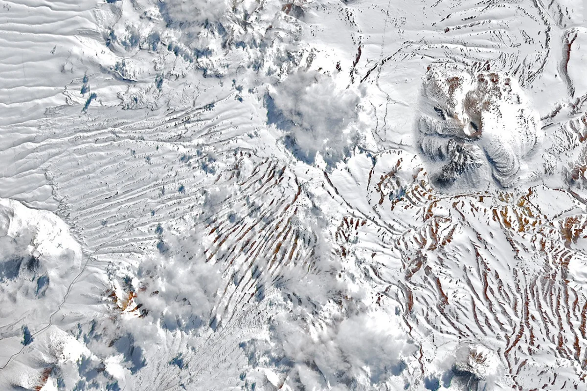
Northern Chile, home to the world’s driest non-polar desert, the Atacama, experienced an extraordinary series of winter storms in August 2026, which deposited rare and unusually widespread snowfall across the typically parched landscape. These back-to-back meteorological events transformed vast stretches of the arid region, from the high peaks of the Andes to surprisingly close to the Pacific coast, culminating in significant disruptions to critical scientific infrastructure and local communities. The phenomena, captured by an array of NASA and USGS satellite imagery, underscore the complex and sometimes dramatic influence of large-scale climate patterns like El Niño on regional weather.
A Chronology of Unseasonal Weather in the Atacama
The unusual weather began to manifest significantly in early August 2026. Satellite observations from the NASA-USGS Landsat 8 and Landsat 9 missions provided a stark before-and-after perspective. Images captured by the Operational Land Imager (OLI) on August 6 and then again on August 14, following the first period of severe weather, revealed a detailed view of the Chajnantor plateau. This elevated expanse, nestled within the Altiplano-Puna volcanic complex, is globally renowned as the home of the Atacama Large Millimeter/submillimeter Array (ALMA), one of the planet’s most powerful radio telescopes. As the initial snow and accompanying high winds descended upon the plateau, ALMA was compelled to suspend its intricate operations, carefully moving its sensitive antennas into a protective survival mode to safeguard them against the uncharacteristic winter elements.
Just as the region began to contend with the aftermath of the first system, a second, even more potent storm swept through in the latter half of August. This subsequent event, documented by the Moderate Resolution Imaging Spectroradiometer (MODIS) on NASA’s Terra satellite on August 19, showcased an astonishingly broad expanse of fresh snowfall. The satellite imagery confirmed snow extending dramatically westward from the towering Andes, blanketing the hyper-arid core of the Atacama Desert, and reaching remarkably close to the Pacific coastline, particularly south of the bustling Chilean port city of Antofagasta. This coastal strip is vital for global astronomy, hosting several other major observatories that also reported suspended operations due to the severe weather, highlighting the widespread impact of the unprecedented precipitation.
While August 2026 brought the most dramatic events, the region had already experienced significant weather anomalies earlier in the year. A major event in July 2026 had already brought considerable impacts to Chile’s Norte Chico region, signaling a winter season that was anything but typical for this dry corner of the world. These earlier incidents served as a precursor, hinting at the amplified atmospheric instability that would fully unfold in August.
The Atacama: A Desert Transformed by Winter’s Embrace
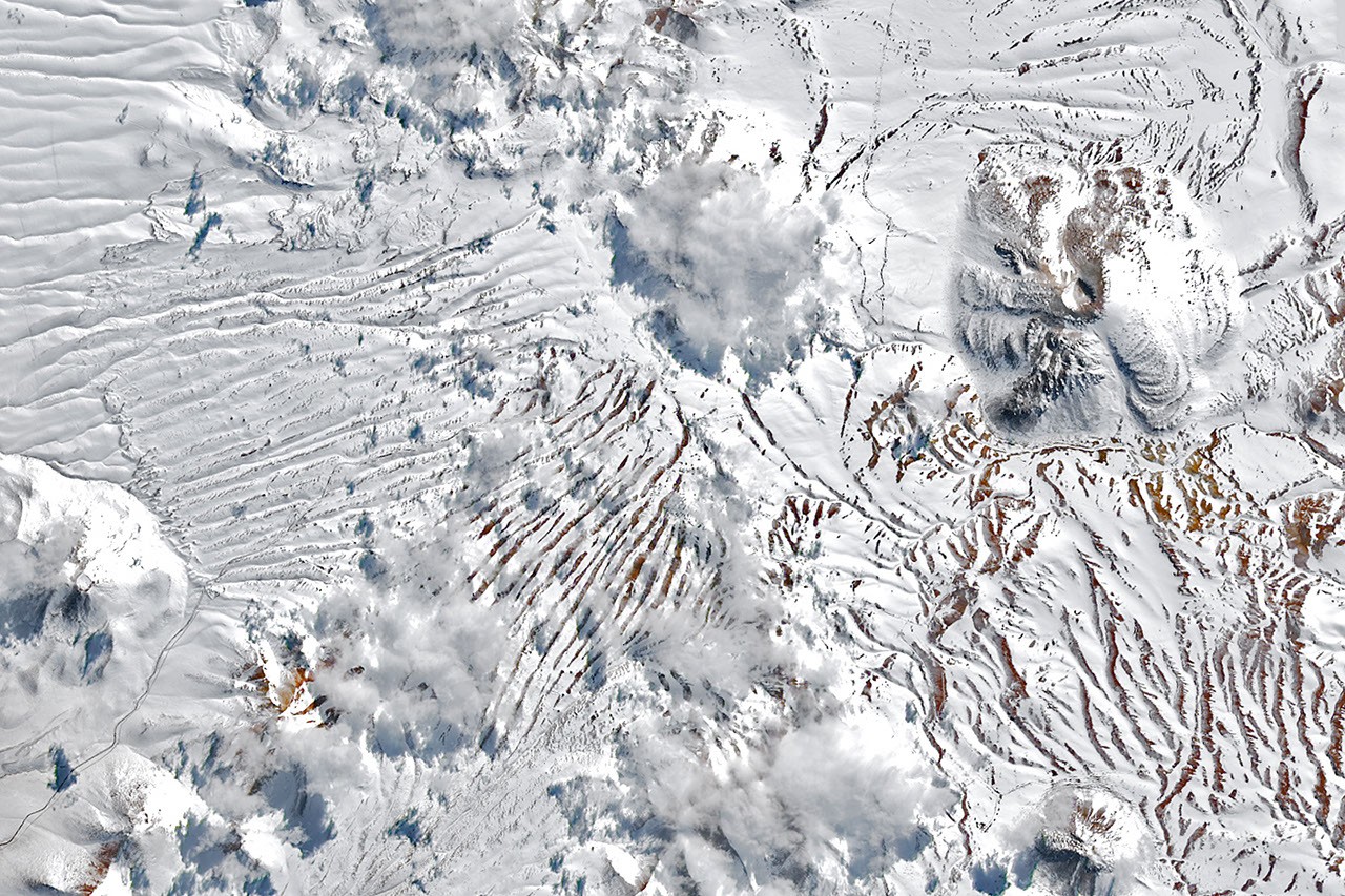
The Atacama Desert holds the distinction of being one of the driest places on Earth, with some areas receiving virtually no rainfall for decades, or even centuries. Its extreme aridity is primarily attributed to a persistent subtropical high-pressure system, the rain shadow effect of the Andes mountains to the east, and the cold, upwelling waters of the Humboldt Current along its western flank. Historically, snowfall in the Atacama is an exceptionally rare occurrence, typically confined to the highest elevations of the Andes. While the region has seen snow before, with notable events recorded in 2011 and more recently in 2025, the August 2026 storms were distinguished by their unusual widespread nature and intensity. The extension of snow from the Andes across the hyper-arid core and close to the Pacific coast was a geographical reach seldom, if ever, witnessed in recent memory, making the 2026 event particularly remarkable.
The images from space provided an invaluable perspective on this transformation. The normally stark, reddish-brown and ochre tones of the desert were temporarily muted by a pristine white mantle, a visual testament to the profound shift in atmospheric conditions. This vast geographical scope of the snowfall created a temporary, surreal landscape, confounding both residents and scientific observers.
Meteorological Mechanisms Behind the Anomalies
Understanding the meteorological forces that conspired to produce such an extraordinary event is crucial. Renée Garreaud, a distinguished atmospheric scientist at the University of Chile, provided expert insights into the mechanisms at play. Garreaud explained that much of the region’s infrequent winter precipitation typically originates from "cutoff lows"—low-pressure systems that become detached from the main jet stream and can occasionally meander into northern Chile. This was indeed the case for the 2025 snowfall event, offering a historical precedent for such phenomena.
However, the late-August 2026 storm was a more complex and expansive affair. While it also stemmed from a cutoff low, this particular system was spawned by an unusually large "trough"—an elongated area of relatively low atmospheric pressure—that stretched across an enormous portion of the Southern Hemisphere. This vast atmospheric disruption extended from the southernmost tip of South America all the way into the subtropics, creating a far-reaching zone of instability.
Crucially, this atmospheric anomaly combined with an ample supply of coastal moisture. The interaction between the expansive low-pressure system and the moist air from the Pacific Ocean generated precipitation that spanned an unusually wide swath of the region. This included areas offshore, along the immediate coast, across the core of the Atacama Desert, and over the high Andes. Garreaud emphasized that the total precipitation recorded reached a magnitude "rarely seen in the otherwise extremely arid region." In some localities, the precipitation fell as rain rather than snow. For instance, Taltal, a town situated on Chile’s northern coast, accumulated nearly 40 millimeters (approximately 1.6 inches) of rain over a mere three-day period. This quantity is astounding for the region, representing roughly ten times its annual mean rainfall. Garreaud underscored the extreme rarity of such events, stating, "We see these kinds of events only a few times, if any, per decade."
El Niño’s Deepening Influence: The Overarching Climatic Backdrop
The strengthening El Niño phenomenon emerged as the overarching climatic backdrop for this anomalously wet winter in north-central Chile. El Niño, characterized by the warming of sea surface temperatures in the central and eastern tropical Pacific Ocean, significantly alters global atmospheric circulation patterns, often leading to shifts in weather extremes worldwide.
In the context of the southeastern Pacific, a strengthening El Niño typically instigates specific atmospheric changes that directly impact Chile’s climate. Firstly, the subtropical Pacific high-pressure system, which normally acts as a dominant weather regulator keeping the region dry, tends to weaken during El Niño events. This weakening allows moisture-laden systems to penetrate further inland. Secondly, a "blocking high" pressure system frequently forms in the South Pacific, often near the tip of the South American continent. The combined effect of a weakened subtropical high and a blocking high is to push the Southern Hemisphere storm track equatorward. This shift diverts weather systems, including cutoff lows and troughs, into latitudes that typically experience stable, dry conditions, thereby increasing the likelihood of unseasonal precipitation events in areas like northern Chile. The July and August 2026 events provided compelling evidence of this mechanism in action, demonstrating how large-scale oceanic-atmospheric teleconnections can manifest in dramatic local weather.
Impact on Critical Infrastructure and Human Settlements
The unseasonal weather had immediate and profound consequences for both the region’s critical scientific infrastructure and its human inhabitants.
Astronomical Observatories Under Siege: The Atacama Desert is renowned globally as a prime location for astronomical observation, largely due to its high altitude, extremely dry air, and minimal light pollution, offering unparalleled clarity for stargazing. The Chajnantor plateau, home to ALMA, is particularly vital. ALMA, a collaboration of global scientific organizations, operates an array of 66 high-precision antennas designed to observe the universe at millimeter and submillimeter wavelengths, providing crucial insights into star formation, distant galaxies, and the origins of the cosmos. Snowfall and high winds pose a significant threat to these delicate instruments. Snow accumulation can interfere with the precision of the parabolic dishes, while strong winds can damage the structures or cause misalignments, requiring extensive and costly recalibration. The decision by ALMA to suspend operations and move its antennas into a protective survival mode underscores the severity of the conditions and the imperative to protect billions of dollars worth of scientific equipment. Similarly, other major observatories located closer to the Pacific coast, south of Antofagasta—such as those on Cerro Paranal (home to the Very Large Telescope) or Cerro Armazones (site of the future Extremely Large Telescope)—also faced disruptions, highlighting the widespread vulnerability of this critical scientific hub to extreme weather.
Devastation on the Ground: Beyond the scientific community, local populations bore the brunt of the storms. The abundant precipitation, particularly the heavy rainfall in coastal areas, spurred destructive mudflows and flash flooding across parts of northern Chile. The arid soil, unaccustomed to such volumes of water, quickly became saturated, leading to landslides and rapid runoff that overwhelmed natural drainage systems and infrastructure. The National Disaster Prevention and Response Service (SENAPRED) issued urgent reports confirming that thousands of individuals were affected by the events, with hundreds of homes sustaining major damage. Infrastructure such as roads, bridges, and utilities were compromised, severing access to remote communities and complicating relief efforts. The sheer volume of water in a region built on the expectation of extreme aridity presented a unique challenge for disaster response, requiring rapid mobilization of resources to areas ill-equipped for such an influx. The economic toll on affected families and local governments was substantial, necessitating long-term recovery and rebuilding efforts.
Broader Ecological and Economic Implications
The rare snowfall and heavy rains in the Atacama Desert present a complex duality of ecological impacts. In the short term, such events can trigger the phenomenon of "flowering desert" (desierto florido), where dormant seeds, sometimes lying in the soil for decades, germinate rapidly, transforming barren landscapes into vibrant carpets of wildflowers. While visually stunning and a temporary boost for local biodiversity, these ephemeral blooms are often short-lived.
However, the long-term ecological implications are more concerning. The sudden and intense precipitation, especially coupled with mudflows, can lead to significant soil erosion, altering delicate desert ecosystems that have evolved to thrive in extreme dryness. The disruption of fragile soil crusts and the washing away of nutrient-poor topsoil can have lasting effects on vegetation recovery and overall ecosystem stability. For unique desert fauna, sudden flooding can be devastating, displacing habitats and overwhelming species unadapted to aquatic environments.
Economically, the region, which relies heavily on mining (particularly copper), astronomy, and increasingly tourism, faced disruptions. Mining operations, often located in remote areas, could have been impacted by impassable roads and operational suspensions. Tourism, while potentially boosted by the novelty of a "snowy desert" in the long run, faced immediate cancellations and logistical challenges. The costs associated with emergency response, infrastructure repair, and housing reconstruction represent a significant economic burden for a region not typically prepared for such extensive weather-related damage.
Looking Ahead: A New Normal?
The August 2026 storms in northern Chile serve as a powerful reminder of the vulnerability of even the most extreme environments to shifts in global climate patterns. While individual weather events cannot be solely attributed to climate change, their intensity, frequency, and geographical reach are increasingly viewed within the broader context of a changing climate. The strengthening El Niño played a demonstrable role in this particular event, and understanding how such phenomena interact with long-term climate trends is critical for future preparedness.
For scientists, the event provides invaluable data for refining climate models and improving forecasting capabilities for arid regions. For policymakers and local communities, it underscores the urgent need for enhanced disaster preparedness strategies, resilient infrastructure development, and adaptive land-use planning in areas historically considered immune to such extreme precipitation. Continued monitoring by satellite missions and ground-based meteorological stations will be essential to track future anomalies and assess whether such events become more common, potentially heralding a "new normal" for the world’s driest desert.
The image of a snow-covered Atacama, a stark contradiction to its enduring reputation, will remain etched in the collective memory, a potent symbol of nature’s unpredictable power and the intricate interconnectedness of our planet’s climate systems.