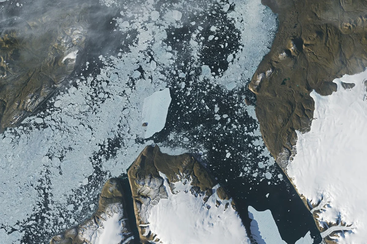
In August 2026, a substantial iceberg, roughly the size of St. Thomas in the U.S. Virgin Islands, calved from the Petermann Glacier along Greenland’s northwest coast, subsequently drifting into Nares Strait and colliding with Joe Island. This event, measuring just over 76 square kilometers (29 square miles), marks the largest calving from an Arctic glacier since 2020, drawing significant attention from the global scientific community. The Petermann Glacier, a critical marine-terminating outlet, plays a vital role as a "gatekeeper" for ice flowing from the Greenland ice sheet into the ocean, making its stability a key indicator for future sea level rise projections.
The Anatomy of a Calving Event: Petermann’s Critical Role
Petermann Glacier is one of Greenland’s largest and most dynamic outlet glaciers, characterized by its extensive floating ice tongue that extends far into the fjord. Unlike many glaciers that terminate directly at the ocean’s edge, Petermann’s ice tongue acts as a buttress, slowing the flow of ice from the vast interior ice sheet. This unique structure makes it a focal point for glaciological research, as changes to its ice tongue can have profound implications for the rate at which ice is discharged into the ocean. The natural process of iceberg calving, where chunks of ice break off from a glacier, is a routine part of an outlet glacier’s life cycle. However, scientists closely monitor these events, along with other observations of the ice and its environment, for longer-term signs of instability that could signal an acceleration in ice loss.
The health and behavior of glaciers like Petermann are intrinsically linked to global climate patterns. Warmer ocean waters can erode the underside of floating ice tongues, thinning them and making them more susceptible to fracturing. Similarly, warmer air temperatures contribute to surface melt, which can seep into crevasses and expand them, further destabilizing the ice. The 2026 calving event, while a natural phenomenon, occurs within a broader context of accelerated ice loss across the Arctic, a region experiencing disproportionately rapid warming.
Chronology of the August 2026 Event
The dramatic calving event was first detected on August 4, 2026, by Adam Garbo, a doctoral student in glaciology at the University of Ottawa. Utilizing imagery from the European Space Agency’s (ESA) Sentinel-1 mission, Garbo and an international team of colleagues, who have been employing remote sensing techniques to study and track Petermann’s ice tongue, quickly identified the newly formed tabular iceberg, often referred to as an "ice island" due to its flat-topped, table-like shape.
The initial assessment revealed that the ice island measured approximately 76 square kilometers. Interestingly, Garbo noted a slight surprise among the research team. They had been anticipating a major calving event from Petermann, as they were closely monitoring several large rifts that appeared poised to cut across the entire ice tongue. However, the August 2026 calving instead followed a different, previously less prominent fracture, resulting in a smaller ice island than their initial projections based on the larger, monitored rifts. As of late August, two of these larger rifts remained, holding the potential to produce future ice islands of roughly 94 square kilometers and 84 square kilometers, though the precise timing of these anticipated events remained uncertain.
Following its detachment, the colossal iceberg embarked on a journey down Petermann Fjord towards Nares Strait. Glaciologist Mauri Pelto of Nichols College meticulously tracked the iceberg’s progress using images from NASA-USGS Landsat satellites. Over the first week post-calving, the berg maintained an average drift rate of approximately 3 kilometers per day. This steady movement brought it to the fjord’s mouth, where it encountered Joe Island (also known as Joe Ø), a small, rocky outcrop situated at a critical juncture before the open waters of Nares Strait. The collision with Joe Island, a common obstacle for departing ice islands, was captured in vivid detail by the Operational Land Imager (OLI) on Landsat 9, with images from August 23 and August 24 providing critical visual evidence of the encounter.
The Eyes in the Sky: Remote Sensing and Glaciology
The ability to precisely detect, measure, and track such immense natural events from thousands of kilometers away is a testament to the advancements in remote sensing technology. The ESA’s Sentinel-1 mission, a constellation of radar imaging satellites, is particularly adept at monitoring ice conditions. Its radar capabilities allow it to penetrate cloud cover and operate independently of daylight, providing continuous, all-weather observations crucial for tracking dynamic phenomena in often cloudy, polar regions. This was instrumental in Garbo’s initial discovery.
Complementing Sentinel-1, the NASA-USGS Landsat program, a long-running series of Earth observation satellites, provides high-resolution optical imagery. Landsat 9, launched in 2021, carries the Operational Land Imager (OLI-2) and the Thermal Infrared Sensor 2 (TIRS-2), which capture detailed visible, near-infrared, and shortwave infrared data. This optical data allows glaciologists like Pelto to observe surface features, track the precise trajectory of icebergs, and monitor changes in their morphology as they drift and fracture. The synergy between radar and optical satellite data provides a comprehensive picture, allowing scientists to piece together the narrative of such complex events, from the initial fracture to the iceberg’s subsequent journey. These satellite missions, along with the dedicated efforts of glaciologists, form the bedrock of modern polar research, enabling an unprecedented level of vigilance over Earth’s cryosphere.
Understanding the Scale: Past and Present Calvings
The August 2026 ice island, while significant, is not Petermann Glacier’s largest contribution to the ocean in recent memory. The glacier has a history of dramatic calving events, serving as a powerful reminder of the dynamic nature of Greenland’s ice sheet. In 2008, a 31 square-kilometer ice island broke away. This was followed by an even more substantial event in 2010, when an ice island exceeding 250 square kilometers calved, roughly four times the size of Manhattan. Just two years later, in 2012, another massive ice island, measuring 130 square kilometers, detached.
These historical events underscore a pattern of large-scale ice loss from Petermann. The 2026 event, at 76 square kilometers, falls within this established range of significant calvings, reinforcing the glacier’s active role in the global ice budget. Scientists classify these large, flat-topped icebergs as "ice islands" to distinguish them from the more irregularly shaped "icebergs" typically calved by tidewater glaciers. Petermann’s ice islands tend to be thinner and more fragile than the towering bergs produced by fast-flowing glaciers like Greenland’s Jakobshavn and Helheim, and considerably less robust than the colossal ice shelves of Antarctica, which can produce ice islands spanning hundreds or even thousands of square kilometers. This relative fragility means they are more susceptible to fragmentation once they leave the protective confines of the fjord.
The Journey Ahead: Drift, Fragmentation, and Hazards
The encounter with Joe Island at the mouth of Petermann Fjord is often a pivotal moment for these ice islands. Historically, collisions with this rocky outcrop have marked the beginning of a berg’s breakup, such as the event in 2010 that famously split a large ice island in two. Therefore, the scientific community watched with bated breath as the 2026 ice island approached Joe Island. Adam Garbo expressed the team’s impression, noting, "We were certainly watching closely as it interacted with Joe Island and were impressed that it survived the interaction without further fragmentation." This resilience, given the berg’s estimated thickness of less than 150 meters at the time of calving, was a notable observation.
Following its relatively unscathed passage past Joe Island, wind and surface currents began to sweep the ice island out of the fjord. Satellite images confirmed its pivoting away from the island and its continued trajectory southwest through Nares Strait, a narrow and often ice-choked waterway separating Greenland from Ellesmere Island. However, this survival is likely temporary. As the ice island continues its journey, exposed to the relentless forces of the open sea, it is expected to fracture into progressively smaller pieces. Tides, powerful winds, ocean currents, and the continuous process of melting will gradually weaken the ice, leading to its eventual disintegration.
The ultimate fate of such ice islands can be varied. Thicker bergs that calve directly from tidewater glaciers without floating ice-shelf extensions can often drag along or even become grounded on the seafloor within fjords. Petermann’s ice islands, though thinner, can also run aground later in their drift, with many historical ice islands and their fragments having become "grounded" off the coasts of Coburg and Baffin islands, significantly further south and west from their origin.
The potential for these ice islands and their fragments to travel considerable distances poses several practical and environmental concerns. They represent potential hazards to marine activities, including shipping lanes, fishing operations, and offshore infrastructure such as oil and gas platforms. Furthermore, as these massive freshwater reservoirs melt, they distribute significant volumes of freshwater into the ocean. This influx can influence local ocean currents, affect marine ecosystems, and alter salinity levels, with potential cascading effects on regional oceanography and biology.
Broader Implications: Sea Level Rise and Arctic Climate
The calving of the Petermann Glacier’s ice island in 2026 is more than an isolated geological event; it is a critical data point in the ongoing scientific effort to understand the dynamics of the Greenland Ice Sheet and its contribution to global sea level rise. Petermann’s role as a "gatekeeper" means that changes in its stability directly impact the rate at which ice from the interior of Greenland reaches the ocean. Should the glacier’s ice tongue continue to thin and retreat, it could unbuttress the ice sheet, potentially accelerating the flow of ice and increasing its contribution to sea level.
Current projections for global sea level rise, notably those from the Intergovernmental Panel on Climate Change (IPCC), highlight the significant uncertainty associated with the future behavior of large ice sheets like Greenland’s. Events like the 2026 calving provide invaluable real-world data to refine these models and improve the accuracy of future predictions. The continuous monitoring of Petermann and other major Arctic glaciers is therefore not merely academic; it is essential for coastal communities worldwide grappling with the challenges of rising sea levels.
The accelerated pace of Arctic warming, often referred to as Arctic amplification, is a key backdrop to these glacial dynamics. As air and ocean temperatures continue to rise, the processes that contribute to glacier retreat and increased calving frequency are likely to intensify. While glaciologists emphasize that calving is a natural process, the observed changes in frequency, size, and location of these events are increasingly seen as indicators of a rapidly changing climate. The scientific community remains vigilant, utilizing an ever-evolving suite of satellite and ground-based observations to decode the complex interplay between climate change and the magnificent, yet vulnerable, ice sheets of our planet.
In conclusion, the August 2026 calving event from Petermann Glacier serves as a potent reminder of the dynamic forces at play in the Arctic. It underscores the critical role of long-term satellite monitoring and dedicated glaciological research in understanding our planet’s changing cryosphere. As the fragments of this latest ice island drift and eventually melt, they will contribute to the ongoing story of Greenland’s ice, a story with profound implications for global sea levels and the future of our climate.