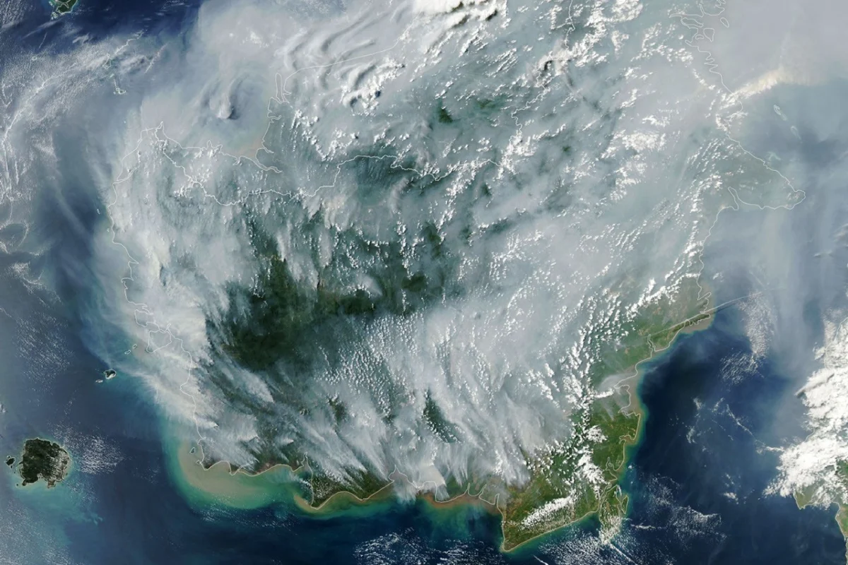
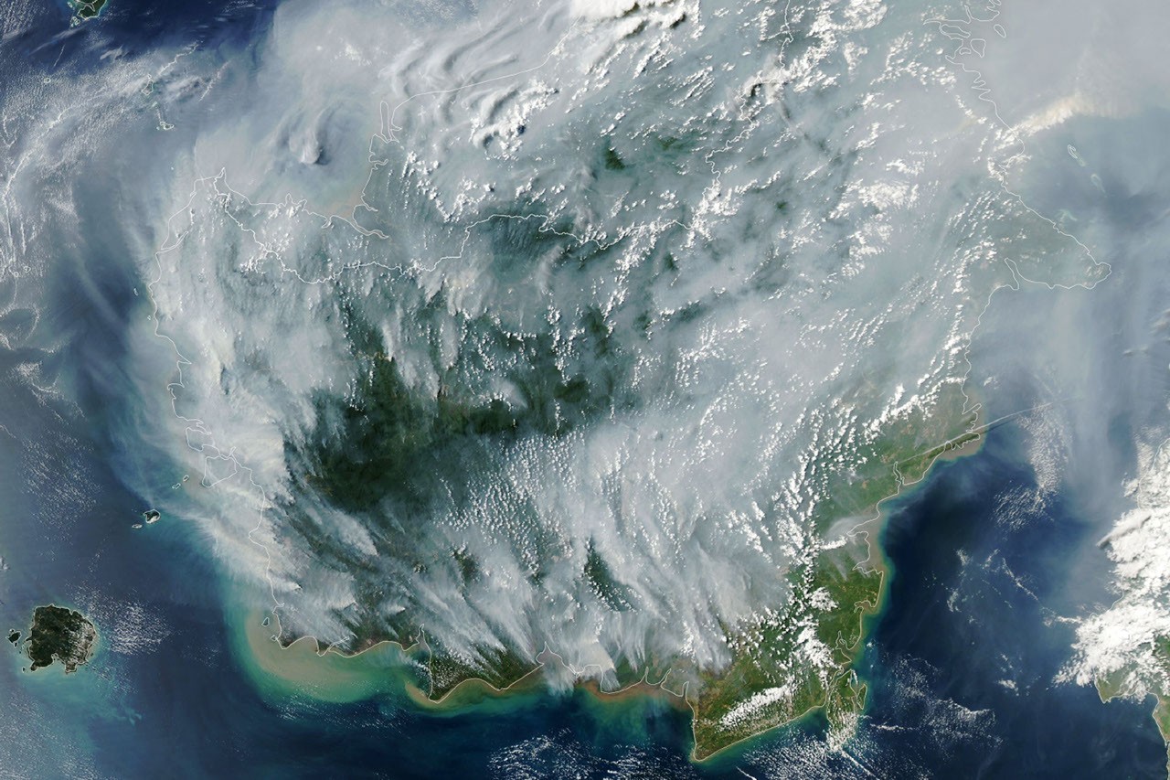
As Indonesia endures a severe drought, a pervasive and destructive environmental crisis is unfolding across the archipelago: fires are not merely burning on the surface but are also smoldering insidiously underground, particularly within its vast tropical peatlands. This dire situation, highlighted by satellite imagery captured on September 1, 2026, underscores a recurring environmental challenge with profound implications for public health, regional stability, and global climate goals. The Moderate Resolution Imaging Spectroradiometer (MODIS) on NASA’s Aqua satellite provided a stark visual of this escalating crisis, with numerous red dots—each representing a thermal anomaly indicative of fire—scattered across the landscape, signaling the onset of what experts fear could be another devastating fire season.
The Perilous Nature of Tropical Peatland Fires
Tropical peatland fires are widely regarded as an apex predator among conflagrations due to their unique characteristics and devastating impact. Unlike typical forest fires that consume surface vegetation, these fires ignite in dried wetland soils, burning through expansive, organic-rich peat deposits. This subterranean combustion makes them notoriously difficult to detect, contain, and extinguish. Peat, a dense accumulation of partially decayed vegetation, acts as a potent fuel source, allowing fires to smolder at low temperatures for weeks or even months, often unseen beneath the surface.
The environmental consequences of peat fires are exceptionally severe. According to one estimate, these fires generate three times more fine particulate matter than other tropical forest fires, releasing hazardous airborne pollutants that severely degrade air quality and pose significant health risks. Beyond particulates, they produce five times more sulfur dioxide, three times more organic carbon, and twice the amount of methane and carbon monoxide. Methane and carbon monoxide are potent greenhouse gases, contributing significantly to climate change. The release of vast quantities of stored carbon from peatlands, which act as massive carbon sinks, exacerbates global warming, creating a dangerous feedback loop. The sheer volume of emissions from these fires transforms them from a localized environmental issue into a global climate concern.
Indonesia’s Vulnerability and Historical Context
Indonesia is uniquely vulnerable to peatland fires, being home to approximately 36 percent of the world’s tropical peatlands. These critical ecosystems, vital for biodiversity and carbon sequestration, become highly flammable when parched by prolonged drought. Over the past three decades, Indonesia’s peat landscapes have repeatedly transformed into unrelenting infernos, especially during periods of extreme dryness. These events have consistently produced blankets of acrid smoke, known as haze, that can persist for weeks, disrupting daily life for millions of people across Indonesia and neighboring countries like Singapore and Malaysia. The economic toll, including healthcare costs, lost productivity, and tourism impacts, runs into billions of dollars with each major fire season.
Historical data reveals a clear pattern: while fires occur in Indonesia annually, previous strong El Niño years—most notably 1997 and 2015—produced the most extreme burning events. The 1997-1998 El Niño-Southern Oscillation (ENSO) event, combined with a strong positive Indian Ocean Dipole (IOD), led to widespread fires that covered an estimated 9.7 million hectares, releasing an estimated 0.81 to 2.57 billion tonnes of carbon into the atmosphere, equivalent to 13-40% of global fossil fuel emissions that year. The 2015 fires, though covering a smaller area, were particularly intense in peatlands, releasing 1.75 billion tons of greenhouse gas equivalents—surpassing Japan’s annual emissions. These past events serve as a grim benchmark against which the current 2026 fire season is being measured.
The Exacerbating Influence of El Niño and the Indian Ocean Dipole in 2026
The current fire season in 2026 is unfolding under exceptionally challenging climatic conditions. The El Niño climate pattern, assessed by NOAA as "present and strengthening" in August, is a primary driver of the intensified drought. El Niño typically brings sharp reductions in rainfall to Indonesia, leading to unusually dry conditions. This effect is further exacerbated when combined with a positive phase of the Indian Ocean Dipole (IOD), which was also present in 2026. The IOD, a phenomenon characterized by a difference in sea surface temperatures between the western and eastern Indian Ocean, can amplify the drying effect of El Niño, particularly in Sumatra and Kalimantan, two of Indonesia’s most fire-prone regions. This dual climatic phenomenon creates a perfect storm for peatlands, lowering the water table to critical levels and making them highly susceptible to ignition.
Robert Field, a Columbia University researcher and developer of the Global Fire Weather Database, which provides experimental, real-time fire weather forecasts, expressed concern over the rapid escalation. "Indonesia is only about three weeks into its fire season, but we’re seeing fire activity track sharply upward, similar to 2015," Field stated. He further elaborated, "The strong El Niño is making the dry season drier over the fire-prone parts of the country and exacerbating burning—just as we anticipated it would." His observations underscore the predictable yet devastating impact of these climate patterns. As of September 2, Indonesia’s 2026 fires, having burned for approximately one month, had already released roughly 10 percent of the greenhouse gas equivalents emitted by the 2015 fires, indicating a rapid and worrying trajectory. This early surge in emissions highlights the potential for the 2026 season to approach or even exceed the catastrophic levels of previous years if dry conditions persist.
The Anatomy of the 2026 Drought and Persistent Subterranean Threats
The severe and widespread drought gripping Indonesia in summer 2026 is a critical factor in the current crisis. Data from the Indonesian meteorological agency indicated that approximately 90 percent of the country received little to no rainfall in early August. This prolonged lack of precipitation has dramatically lowered water tables across the archipelago, particularly in regions with extensive peatlands like Kalimantan, Sumatra, and Papua. Under normal conditions, these wetland areas are too saturated for fires to spread significantly underground. However, in dry conditions, the peat becomes highly combustible, allowing fires to burrow deep and smolder unseen.
"Surface fires are less of a concern, but when fires get underground, they just won’t stop," Field explained. The subterranean nature of peat fires makes them incredibly resilient and difficult to combat using conventional firefighting methods. Aerial water bombing and ground crews dousing flames often only address the visible surface fires, leaving the underground embers to reignite later. "They’ll keep burning until the rains come in October or November," Field predicted, emphasizing the prolonged nature of the threat and the reliance on seasonal weather changes for ultimate relief. This characteristic makes these fires a persistent, long-term challenge requiring extensive resources and strategic planning. The smoldering fires release smoke continually, contributing to the prolonged haze events that have become a hallmark of Indonesia’s dry seasons.
Challenges in Monitoring and Detection
The Indonesian government actively utilizes advanced satellite observations from NASA and NOAA, specifically data from the MODIS and Visible Infrared Imaging Radiometer Suite (VIIRS) sensors, to track active fires in near-real-time. Platforms like SiPongi, the Ministry of Forestry’s MODIS- and VIIRS-based fire-monitoring system, are crucial tools. On August 31, 2026, SiPongi tallied 946 hotspots, providing immediate intelligence for deployment of firefighting resources. However, even with sophisticated satellite technology, accurately monitoring peat fires presents significant challenges.
Thick smoke plumes, dense cloud cover, and the nature of the fires themselves—often burning within the forest understory or entirely underground in peat deposits—can obscure detections. Mark Cochrane, an ecologist at the University of Maryland Center for Environmental Science who has conducted nearly a decade of field research on Indonesian peat fires, highlighted a paradoxical situation. "The worst smoke events, paradoxically, can be the hardest to observe from space with MODIS and VIIRS," Cochrane noted. When fires become most intense and produce the heaviest smoke, the very conditions that indicate a severe crisis can impede satellite sensors from accurately detecting the full extent and number of fires. This limitation means that the true scale of the burning, particularly the insidious underground fires, may often be underestimated by conventional satellite monitoring.
Historical Roots of Vulnerability and Mitigation Efforts
The current vulnerability of Indonesia’s peatlands is not solely a product of climate phenomena but also a legacy of past land use policies and economic development initiatives. Cochrane pointed out that the large-scale construction of irrigation canals and the drainage of peat swamps in the 1990s significantly contributed to the region’s present flammability. These efforts were part of ambitious "mega-rice projects" aimed at establishing massive rice farms, which inadvertently lowered the water table in vast wetland areas. This drainage transformed previously waterlogged peat, which is naturally fire-resistant, into a dry, highly combustible fuel source.
Furthermore, the widespread expansion of oil palm and other plantation forestry in these regions has often involved extensive land clearing, frequently using fire, and further drainage, exacerbating the problem. The practice of "slash and burn" agriculture, though often illegal, persists as a cheap method for land preparation, leading to accidental or deliberate ignitions that can quickly spread to dried peat.
Following the exceptionally grim fire season of 2015, there has been a concerted effort by governments and various organizations to implement mitigation measures. These include initiatives to dam up irrigation canals to re-wet peatlands, restore degraded wetland ecosystems, and improve the overall firefighting capacity of local and national agencies. There have also been renewed efforts to educate communities and enforce regulations to reduce the number of fires accidentally or deliberately ignited by people.
A "Stress Test" and Future Detection Technologies
The current 2026 fire season is being closely watched as a critical "stress test" for the measures put in place since 2015. Shi Jun Wee, a University of Maryland graduate student, is part of a team partnering with NASA and MapBiomas to develop innovative solutions for fire detection. His work focuses on creating new algorithms and techniques to detect more understory fires than currently possible with MODIS and VIIRS. This involves leveraging shortwave infrared observations from Landsat and Sentinel-2 satellites, which can penetrate smoke and vegetation more effectively, offering a clearer picture of subsurface and obscured fires.
As the fires progress, Wee plans to track developments using a suite of NASA’s advanced data browsers and systems, including Worldview, the Fire Information for Resource Management System (FIRMS), Harmonized Landsat and Sentinel-2 (HLS) observations, and the Global Fire Emissions Database (GFED). These tools will provide a comprehensive understanding of fire activity, spread, and emissions, aiding in both immediate response and long-term research. The success of these new detection methods is crucial for improving early warning systems and more effective deployment of firefighting resources, particularly for the elusive peat fires.

Immediate Societal and Environmental Impact
On the ground in Indonesia and neighboring countries, the smoke haze is already causing widespread disruptions and severe public health concerns. Indonesian officials have issued warnings regarding hazardous smoke exposure for large swathes of the population, leading to a surge in respiratory illnesses. In response, some schools have shifted to remote learning to protect students from the unhealthy air quality. The environmental toll is also mounting, with nine national parks closing to visitors, impacting local economies reliant on tourism and further threatening already endangered species within these ecosystems. Additionally, heavy smoke has caused significant disruptions to air travel, leading to delays and cancellations of numerous flights at airports, including Supadio Airport, as reported by local news outlets. The economic ripple effect extends to agriculture, fisheries, and other sectors heavily impacted by reduced visibility and environmental degradation.
A Call for Sustained Global Focus
Mark Cochrane emphasized a critical aspect of the recurring fire crisis: the tendency for global attention to wane once the immediate threat of El Niño-fueled fires subsides. "People tend to focus on these fires during an El Niño and then forget about them," Cochrane observed. He urged for a sustained commitment, arguing, "We need sustained focus, even during the years when they aren’t as bad, to solve this. These fires create a tremendous amount of emissions." This call for long-term engagement highlights that the problem is not merely episodic but systemic, requiring continuous investment in peatland restoration, sustainable land management practices, enforcement of anti-burning laws, and international cooperation.
The broader implications of Indonesia’s peat fires extend far beyond its borders. The massive release of greenhouse gases contributes to global warming, undermining international efforts to combat climate change. The transboundary haze frequently strains diplomatic relations with neighboring countries, which bear the brunt of the air pollution. Furthermore, the destruction of critical peatland ecosystems leads to irreversible biodiversity loss, threatening unique flora and fauna adapted to these wetlands. Addressing this complex issue requires a multi-faceted approach involving scientific research, technological innovation, robust policy implementation, international collaboration, and sustained public awareness. As the 2026 fire season progresses, the world watches to see if Indonesia, with the support of global partners, can mitigate the unfolding disaster and build a more resilient future for its invaluable peatlands.
NASA Earth Observatory image by Lauren Dauphin, using MODIS data from NASA EOSDIS LANCE and GIBS/Worldview. Story by Adam Voiland.