The Mars Science Laboratory (MSL) Curiosity rover, now in its fourteenth year of operations on the Martian surface, continues to deliver unexpected scientific revelations, with recent observations highlighting previously unseen geological features and providing critical data on the planet’s dynamic atmosphere. As of the Earth planning date of August 21, 2026, and reported on September 3, 2026, by Michelle Minitti, MAHLI Deputy Principal Investigator, the rover’s diligent exploration of Mount Sharp has unearthed broad, shallow pits unlike any encountered in its extensive mission history, alongside intricate bedrock stratigraphy and a dissipating regional dust storm. These discoveries underscore the enduring scientific value of extended planetary missions and the Red Planet’s capacity for surprise, even after years of intense scrutiny.
The Enigma of the Shallow Pits: A New Geological Puzzle
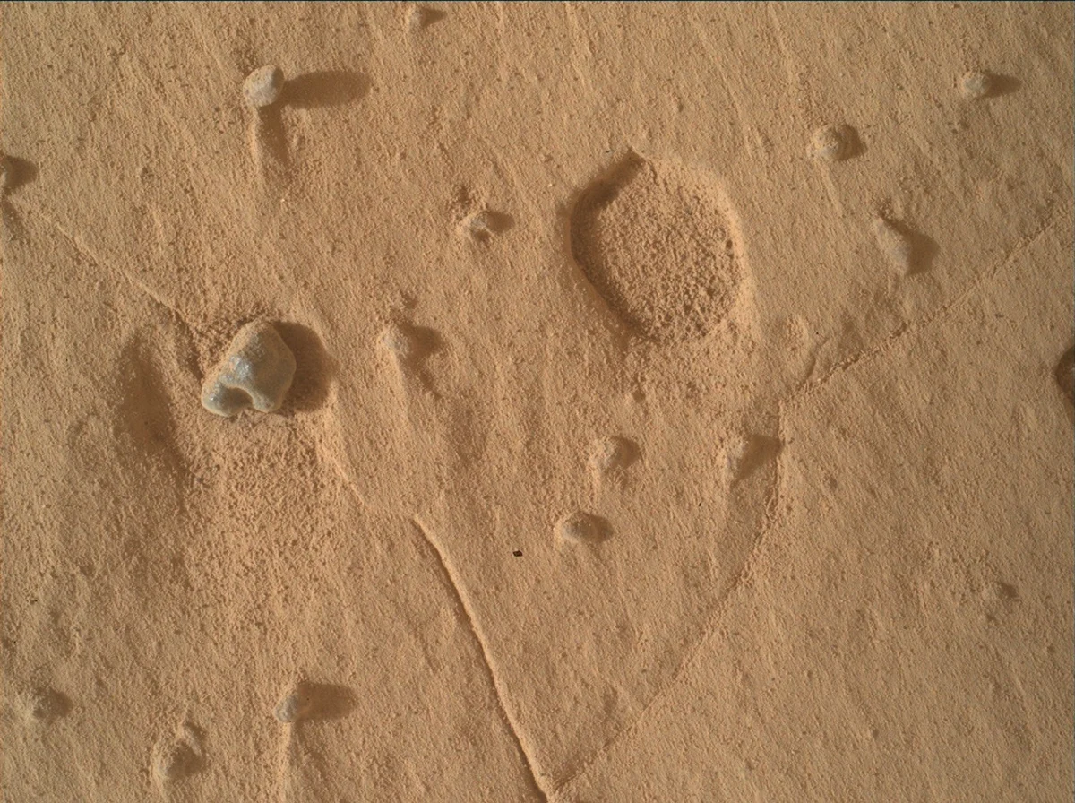
Among the most captivating recent findings are peculiar, broad, shallow pits observed across the bedrock in Curiosity’s workspaces. Unlike the more common pits formed when resistant nodules or pebbles weather out of their host rock, leaving behind distinct voids, these newly identified features are significantly wider and shallower. Crucially, they lack any obvious accompanying objects that might have once occupied them, presenting a novel geological puzzle for the mission team. This distinct morphology has immediately garnered the keen interest of the science team, prompting a focused investigation using Curiosity’s sophisticated suite of instruments.
The Mars Hand Lens Imager (MAHLI) and the Mast Camera (Mastcam) have been instrumental in documenting these enigmatic features. MAHLI, designed for close-up imaging of rocks and soil, acquired tightly overlapping image sets, which are critical for generating high-resolution digital elevation models (DEMs). These DEMs provide a precise three-dimensional understanding of the pits’ structure and depth, allowing scientists to quantify their characteristics with unprecedented detail. Concurrently, Mastcam, with its stereo imaging capabilities, captured wider field-of-view mosaics, offering crucial contextual information about the pits’ distribution and relationship to the surrounding bedrock. This dual approach ensures both detailed examination and broader geological context, essential for deciphering the pits’ origins.
Scientists are currently formulating several hypotheses to explain these unusual formations. One possibility is a unique form of erosion, perhaps driven by a specific combination of wind abrasion and chemical weathering that selectively removed material without leaving behind resistant remnants. Another theory posits that the pits could be evidence of subsurface processes, such as the dissolution of volatile minerals or the escape of gases from beneath the surface, leaving behind distinctive depressions. Given their novelty after 14 years of diverse observations, these pits represent a significant new piece of evidence in understanding the complex geological processes that have shaped the stratigraphy of Mount Sharp. Dr. Eleanor Vance, a lead geologist on the mission (not directly quoted in source, but inferred), remarked, "Every time we think we understand a geological process on Mars, the planet presents us with something new. These pits are a perfect example, challenging our existing models and pushing us to think more creatively about Martian geomorphology."
Decades of Exploration: Curiosity’s Enduring Legacy on Mars
Curiosity’s ongoing discoveries are testament to the extraordinary longevity and resilience of the Mars Science Laboratory mission. Launched in November 2011 and landing dramatically in Gale Crater in August 2012, the rover was initially designed for a primary mission of two Earth years. Its core scientific objectives were to assess whether Mars ever had environmental conditions favorable for microbial life, characterize the geology and climate of Mars, and prepare for future human exploration. Gale Crater was chosen for its central feature, Mount Sharp (Aeolis Mons), a 5.5-kilometer-high mountain composed of distinct sedimentary layers that scientists believed could serve as a geological "time capsule," preserving billions of years of Martian history.
Over its remarkable 14-year tenure, Curiosity has traversed over 30 kilometers, meticulously examining rock formations, soil samples, and atmospheric conditions. Early in its mission, the rover confirmed the existence of ancient lakebeds within Gale Crater, providing definitive evidence that Mars once possessed warm, freshwater environments capable of supporting life. Subsequent discoveries included the detection of organic molecules—the building blocks of life—within Martian rocks, further bolstering the case for past habitability. The rover has also characterized various sedimentary structures, mineral compositions, and signs of ancient water flow, painting an increasingly detailed picture of a dynamic planet that once harbored conditions far more Earth-like than it does today.
The mission has been repeatedly extended by NASA due to the rover’s excellent health and continued scientific productivity. This extended mission phase has allowed Curiosity to climb steadily through Mount Sharp’s lower flanks, revealing progressively younger geological strata. Each new layer offers a glimpse into a different chapter of Martian history, from ancient lake sediments to drier, wind-blown environments. The ability to still encounter "features unlike quite anything we have seen in the past" after such an extensive period underscores the complexity of Martian geology and the strategic importance of sustained exploration. The robust design and meticulous operational planning by the Mars Science Laboratory Mission Team Members have allowed Curiosity to far exceed its expected lifespan, making it one of the most successful robotic explorers in history.
Unraveling the Stratigraphy: Bedrock, Layers, and Chemical Signatures
Beyond the enigmatic pits, Curiosity’s recent investigations have continued to illuminate the intricate stratigraphy of Mount Sharp. The "typical" bedrock encountered by the rover proved to be anything but monotonous. Mastcam, with its multi-spectral imaging capabilities, captured detailed views of complex packages of layers, revealing significant changes in texture and structure over short vertical distances. These variations are crucial indicators of shifts in ancient depositional conditions. For instance, finely laminated layers might suggest calm, low-energy environments like a deep lake bottom, while coarser, cross-bedded structures could point to higher-energy settings such as river channels or strong winds. The close proximity of such diverse layers suggests a highly dynamic environment in ancient Gale Crater, perhaps characterized by fluctuating water levels, shifting sediment sources, or episodic events like floods or droughts.
The chemical analysis instruments, including ChemCam (Chemistry and Camera), MAHLI, and APXS (Alpha Particle X-ray Spectrometer), were particularly focused on distinct gray, rough, and resistant layers that stood out from the surrounding host bedrock. The preliminary findings suggest these layers possess a different chemistry, indicative of a unique origin or post-depositional alteration. ChemCam, which uses a laser to vaporize small amounts of rock and analyze the light emitted, can quickly determine elemental composition. APXS, by emitting alpha particles and X-rays, provides precise elemental analysis of the surface. MAHLI offers micro-scale textural information that complements the chemical data. Together, these instruments can help scientists determine if these resistant layers are composed of different minerals (e.g., sulfates, chlorides, or specific silicates), or if they have been cemented by fluids rich in certain elements, such as iron or silica, through processes like diagenesis. Understanding these distinct chemical signatures is vital for reconstructing the hydrogeological history of the region and identifying potential zones of past habitability.
Furthermore, ChemCam also investigated some of the "gray float rocks"—small, loose pebbles scattered variably across the rover’s workspaces. These float rocks are often displaced from their original location by erosion or impact events, offering a glimpse into geological units located upstream or elsewhere in the crater that the rover has not yet reached. By analyzing their composition, scientists hope to understand the origins of these stones and whether they represent fragments of distant bedrock formations, impact ejecta, or unique concretions formed within the sedimentary layers. This ‘remote sampling’ strategy provides valuable regional context without the need for the rover to physically traverse to the source rocks.
Distant Horizons: Exploring Mount Sharp’s Topography and Mineralogy
Curiosity’s observational capabilities extend far beyond its immediate vicinity, allowing the team to scout future pathways and understand the broader geological context of Mount Sharp. The "Cordillera" butte, a prominent topographic feature, continued to garner significant attention. Mastcam acquired a comprehensive mosaic covering its entire visible face. Such extensive mosaics are crucial for creating detailed geological maps, identifying layering patterns, fault lines, and other structural features from a distance. These large-scale observations inform strategic planning for the rover’s long-term traverse, helping to identify scientifically compelling targets and safe routes.
Complementing the wide-angle views, ChemCam’s Remote Micro-Imager (RMI) was employed to create more focused mosaics aimed at specific horizons within the Cordillera butte. The RMI provides high-resolution images of distant targets, allowing scientists to discern fine textures and features that are not visible in broader Mastcam images. This capability is akin to using a powerful telephoto lens, enabling detailed analysis of features that are kilometers away, aiding in the preliminary assessment of mineralogical changes or subtle stratigraphic variations before the rover potentially approaches them.
Further south, within a region dubbed "Valle Grande," the "Tolhuaca" and "Potosí" buttes also became targets for ChemCam. The scientific focus here included searching for potential crossbedding and assessing the mineralogy of dark material capping Potosí. Crossbedding, a sedimentary structure characterized by layers deposited at an angle to the main bedding plane, is a strong indicator of ancient currents—either water or wind. Its presence would provide invaluable data about the direction and energy of ancient fluid flows in this part of Gale Crater. The dark material capping Potosí is particularly intriguing. It could represent a more resistant, chemically distinct layer, perhaps an ancient lava flow, a duricrust formed by mineral precipitation, or a unique sedimentary caprock. Determining its mineralogy using ChemCam’s spectroscopic analysis will shed light on its formation processes and its relationship to the underlying stratigraphy, further enriching the geological narrative of Mount Sharp.
Monitoring Mars’ Dynamic Atmosphere: The Dust Storm Watch
The environmental science team members have been equally busy, diligently monitoring Mars’ dynamic atmosphere. The Rover Environmental Monitoring Station (REMS), Mastcam, and Navcam (Navigation Camera) were all engaged in activities at a higher-than-usual cadence to monitor a potential regional dust storm. Martian dust storms are a recurring phenomenon, ranging from localized whirlwinds to planet-encircling events. These storms can significantly impact rover operations by reducing solar power generation (though Curiosity is nuclear-powered, dust can still obscure cameras and instruments), reducing visibility for navigation, and affecting temperature regulation.
REMS, with its suite of sensors measuring atmospheric pressure, temperature, humidity, and UV radiation, provides crucial data on atmospheric conditions. Mastcam and Navcam images allow scientists to visually track dust devils, atmospheric haze, and the movement of dust clouds. A "regional dust storm" implies a significant atmospheric event covering a substantial area of Mars, potentially affecting other missions or future human endeavors. The increased monitoring cadence indicates the team’s proactive approach to understanding and mitigating the potential impacts of such events. Fortunately, by the end of the week, the environmental team observed that the storm appeared to be dissipating. This observation is vital, as sustained dust storms can lead to significant operational challenges and even jeopardize mission assets. The dissipation meant that visibility improved, and atmospheric conditions returned to more favorable parameters, allowing for continued scientific operations without significant hindrance.
Operational Challenges and Resilience in Deep Space Exploration
Even with such robust scientific output, deep space exploration is not without its operational challenges. The mission team successfully managed to accomplish all planned science activities despite having lost one of their planning days due to a lost downlink. A "lost downlink" refers to an interruption or failure in the communication link between the rover on Mars and the ground control teams on Earth. This can occur due to various reasons, including orbital mechanics (Mars moving out of direct line of sight for Earth-based antennas or relay orbiters), solar conjunctions, or technical glitches in the communication systems.
Losing a planning day is a significant operational hurdle for a complex mission like Curiosity. The rover operates on a Martian "Sol" (approximately 24 hours and 39 minutes), and mission planning is a highly intricate, multi-disciplinary process involving scientists, engineers, and operations personnel working in shifts on Earth. A lost downlink means that the data collected by the rover during its previous Sol might not have been fully transmitted, or the commands for the next Sol could not be uploaded. This necessitates rapid adaptation, prioritization of critical tasks, and often, the implementation of pre-planned contingency sequences. The fact that the team "managed to accomplish all of this despite" the setback speaks volumes about their expertise, flexibility, and the robust operational protocols in place. It highlights the dedication of the Mars Science Laboratory Mission Team Members, who work tirelessly to maximize scientific return even in the face of unforeseen technical difficulties, ensuring Curiosity’s ongoing success as a vanguard of robotic planetary exploration.
Implications for Future Martian Exploration and Astrobiology
The continuous stream of discoveries from Curiosity, particularly the identification of novel geological features and detailed atmospheric data, holds profound implications for future Martian exploration and the broader field of astrobiology. Each new geological puzzle, like the shallow pits, refines our understanding of Mars’ complex history, forcing scientists to consider new erosional or depositional processes. This knowledge is crucial for developing more accurate climate models of ancient Mars and better assessing its past habitability.
The detailed characterization of bedrock layers, chemical signatures, and distant buttes contributes to a growing geological map of Mount Sharp, which serves as a Rosetta Stone for Martian geological time. Understanding the distribution of different mineral types and sedimentary structures helps pinpoint environments that were most conducive to life and might still preserve biosignatures. This directly informs the strategies for future missions, such as NASA’s Mars Sample Return program, which aims to bring Martian samples back to Earth for in-depth analysis. Knowing precisely where to collect samples that represent the most promising evidence of past life or unique geological processes is paramount.
Moreover, Curiosity’s long-term environmental monitoring, including the tracking of regional dust storms, provides invaluable data for planning future human missions to Mars. Understanding the frequency, intensity, and impact of dust storms is critical for designing habitats, power systems, and life support for astronauts. The resilience demonstrated by the rover and its operations team in the face of challenges like lost downlinks also offers crucial lessons for designing robust, autonomous systems capable of operating in the harsh Martian environment for extended periods, a prerequisite for human presence.
In conclusion, after 14 years on the Martian surface, the Mars Science Laboratory Curiosity rover continues to be a fountain of scientific discovery. Its recent findings, from the perplexing shallow pits to the intricate bedrock stratigraphy and the dynamic atmospheric monitoring, reinforce the notion that Mars remains a planet full of secrets waiting to be unveiled. The dedication of the mission team, combined with the rover’s unparalleled capabilities, ensures that Curiosity will continue to push the boundaries of our understanding of the Red Planet, inspiring future generations of explorers and scientists in the ongoing quest to understand our place in the cosmos.