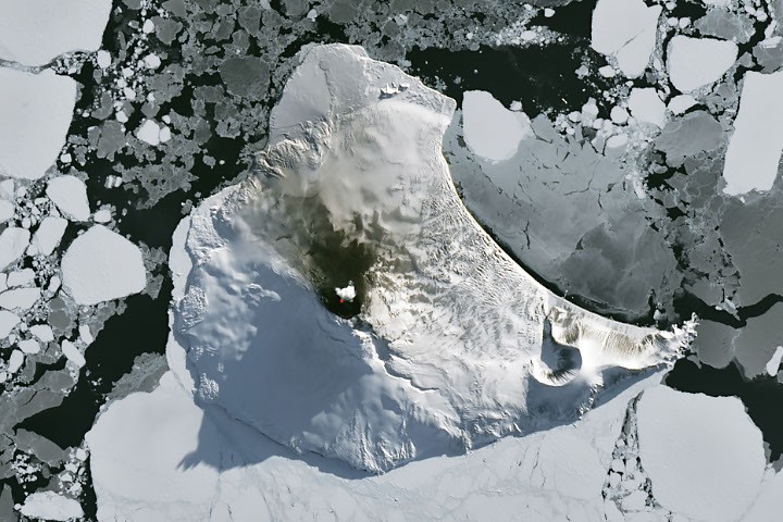
A dramatic satellite image captured on August 24, 2026, has provided a rare, unobstructed view of Mount Michael, a remote stratovolcano on Saunders Island in the South Sandwich Islands, revealing its persistently active lava lake as the austral winter began to release its icy grip. This striking observation, published as the Image of the Day on September 7, 2026, underscores the dynamic geological forces at play beneath one of Earth’s most isolated and inhospitable regions, offering critical insights into volcanic processes typically hidden by extreme weather and vast oceanic expanses.
The Unveiling: A Satellite’s Glimpse into the South Atlantic
The image, acquired by the Operational Land Imager (OLI) on the NASA-USGS Landsat 8 satellite, presents a natural-color view of Saunders Island, an uninhabited volcanic outpost near the Antarctic Circle. What makes this particular capture extraordinary is the overlay of an infrared signal, derived from OLI bands 7-6-5, which vividly highlights the intense heat emanating from Mount Michael’s summit crater in a crimson glow. This fiery signature confirms the presence of a persistent lava lake, a geological rarity. Further indicators of ongoing activity included a distinct puff of a volcanic plume hovering above the 843-meter-high peak, along with noticeable darkened snow on its northern slopes, likely a result of ashfall or deposited volcanic gases.
The timing of this clear observation is particularly noteworthy. Austral winter, characterized by months of frozen darkness, sea ice choking ocean waters, and severe meteorological conditions, typically obscures such views. The transient clearing of clouds provided a precious window for satellite instruments to peer through the atmospheric veil and register Mount Michael’s fiery heart. This brief meteorological reprieve allowed scientists to gather crucial data on a volcano that remains largely inaccessible for ground-based study. The ability of Earth-observing satellites to penetrate these remote and challenging environments is paramount to understanding global volcanism and its broader impact.
Mount Michael: A Rare Persistent Lava Lake
Mount Michael’s persistent lava lake is one of only a handful known to exist globally, placing it in an exclusive club alongside iconic volcanoes such as Kīlauea in Hawaii, Nyamulagira in the Democratic Republic of Congo, and Erta Ale in Ethiopia. These features are not merely pools of molten rock; they represent a delicate balance between magma supply from the Earth’s interior and heat loss to the atmosphere, sustained by a stable conduit system that allows for continuous convection of magma. The existence of such a feature suggests a consistent and robust supply of magma from Mount Michael’s plumbing system, maintaining an open vent and preventing solidification.
The scientific significance of persistent lava lakes cannot be overstated. They act as natural windows into the Earth’s upper mantle, providing a unique opportunity to study the dynamics of magma degassing, heat transfer, and lava rheology in real-time. Continuous observations allow volcanologists to monitor changes in magma composition, gas emissions, and eruptive styles, offering predictive potential for understanding more explosive volcanic behaviors. For Mount Michael, nestled in an extreme environment, its lava lake provides an invaluable natural laboratory, albeit one observed remotely, for investigating how such features can endure under challenging climatic conditions. Researchers hypothesize that the relatively isolated nature of the South Sandwich Plate, coupled with consistent subduction, creates optimal conditions for a steady, deep-seated magma reservoir capable of sustaining this rare phenomenon.
Geological Tapestry of the South Sandwich Islands
Saunders Island is part of the South Sandwich Islands, an arcuate chain of eleven small volcanic islands stretching approximately 350 kilometers (220 miles) across the remote South Atlantic. This rugged and largely uninhabited archipelago is a classic example of an island arc formed by the subduction of an oceanic plate beneath another. Specifically, the South American plate is actively diving beneath the tiny South Sandwich plate, a process that generates intense heat and pressure, leading to the melting of mantle rock and the subsequent rise of magma to the surface, forming volcanoes.
The South Sandwich Trench, reaching depths of over 8,000 meters, marks the subduction zone to the east of the islands, while the East Scotia Ridge, a spreading center, lies to the west. This complex tectonic setting makes the region one of the most volcanically active in the South Atlantic. Regular eruptions have been documented across these islands for centuries, although their remoteness often means that only the largest events are observed without satellite assistance. Mount Michael, with its prominent stratovolcano structure—characterized by steep slopes and explosive eruptions—is one of the most active in the chain, alongside others like Mount Belinda on Montagu Island and Mount Curry on Zavodovski Island, both of which have also displayed significant activity in recent decades. The continuous volcanic activity in this region provides crucial data for understanding plate tectonics, mantle dynamics, and the formation of new crust in oceanic environments.
Eyes in the Sky: The Indispensable Role of Satellite Monitoring
Due to the extreme remoteness and harsh environmental conditions of the South Sandwich Islands, direct, sustained human observation of Mount Michael is logistically challenging and prohibitively expensive. Consequently, scientists have become heavily reliant on satellite data to monitor its activity, track changes, and understand its long-term behavior. The NASA-USGS Landsat program, a cornerstone of Earth observation for over five decades, plays a critical role. Landsat 8 and its successor, Landsat 9, equipped with the Operational Land Imager (OLI), provide high-resolution multispectral imagery that is invaluable for detecting surface changes, including thermal anomalies indicative of volcanic heat. The OLI’s capacity to capture data across multiple spectral bands, particularly in the shortwave infrared, allows researchers to differentiate between various types of surface features and to detect heat signatures that would be invisible in natural color.
Beyond Landsat, a suite of other satellite instruments contributes to this comprehensive monitoring effort:

- Sentinel-2 (ESA’s Copernicus Program): Provides high-resolution optical imagery, complementing Landsat data for broader spatial coverage and more frequent revisits.
- ASTER (Advanced Spaceborne Thermal Emission and Reflection Radiometer) on NASA’s Terra satellite: Offers detailed thermal infrared data, allowing for precise measurements of surface temperature and the detection of subtle thermal anomalies, crucial for identifying nascent volcanic activity or changes in lava lake dynamics.
- MODIS (Moderate Resolution Imaging Spectroradiometer) on NASA’s Terra and Aqua satellites: With its wide swath and daily global coverage, MODIS provides frequent, albeit lower-resolution, thermal observations, enabling long-term monitoring of volcanic hotspots and tracking of large-scale plumes.
- VIIRS (Visible Infrared Imaging Radiometer Suite) on the NOAA-NASA Joint Polar Satellite System (JPSS): Similar to MODIS, VIIRS offers high-quality visible and infrared data, including nighttime lights detection, which can pick up volcanic incandescence.
- Aura satellite (NASA): Specifically, its Ozone Monitoring Instrument (OMI) is vital for detecting and quantifying sulfur dioxide (SO2) emissions. Volcanic SO2 is a key indicator of degassing magma and can have significant atmospheric impacts. Data from Aura have consistently shown that SO2 emissions are common at Mount Michael, reinforcing its active status.
These diverse datasets are integrated through platforms like MIROVA (Middle Infrared Observation of Volcanic Activity), a near-real-time global volcanic hot spot detection system. MIROVA processes thermal data from various satellite sensors to identify and characterize volcanic activity, providing scientists with immediate alerts and historical records. Data from MIROVA have consistently indicated low-intensity but persistent activity at Mount Michael over the past several years, reaffirming the long-term nature of its lava lake. This multi-satellite approach ensures continuous surveillance, overcoming the limitations of any single instrument or platform, and painting a robust picture of volcanic activity in this remote region.
A Chronology of Recent Observations and Atmospheric Phenomena
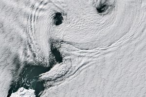
The August 24, 2026, Landsat 8 image marked a critical moment for observing Mount Michael’s persistent lava lake. However, the transient nature of clear skies in the South Atlantic meant this window would soon close. Just one week later, on September 1, 2026, when Landsat 9 passed over Saunders Island, the atmospheric conditions had shifted dramatically. The clear skies had given way to a more active atmosphere, characterized by significant cloud cover.
Yet, even under these more typical conditions, the interaction between the island’s topography and the prevailing weather patterns created a spectacle of its own. The 843-meter-high peak of Mount Michael, jutting sharply from the ocean, disturbed the passing winds, generating a series of mesmerizing wave clouds. These atmospheric formations, resembling the wake of a ship cutting through water, are a familiar phenomenon in this windy, high-latitude region. Known as lee waves or mountain waves, they form when stable air flows over an obstruction, creating oscillations that condense moisture into visible clouds.
Further analysis of false-color imagery captured by NASA’s Aqua satellite on the same date provided additional insights. This imagery indicated the probable presence of a "volcanic track" or plume, caused by the continuous degassing of sulfur dioxide from Mount Michael. Volcanic emissions, particularly SO2, can influence cloud formation and properties by providing aerosols that act as cloud condensation nuclei. This interaction between the volcanic activity and the meteorological conditions highlights the complex interplay between Earth’s geological and atmospheric systems, even in such isolated locales. The ability to distinguish between purely meteorological phenomena and volcanically influenced atmospheric features is another testament to the power of multi-instrument satellite observation.
Decades of Data: Unlocking Mount Michael’s Secrets
The recent observations are not isolated events but rather part of a continuous monitoring effort spanning decades. An extensive analysis of thermal anomalies detected by Landsat, Sentinel, and ASTER observations over a 30-year period has been instrumental in confirming the persistent nature of Mount Michael’s lava lake. This long-term dataset allows volcanologists to track subtle changes in thermal output, infer variations in magma flux, and identify potential precursors to more significant eruptive episodes. The consistency of these thermal signatures over such an extended period is a key indicator of a stable and continuously supplied magmatic system.
Furthermore, the routine detection of sulfur dioxide emissions by instruments like Aura’s OMI reinforces the understanding of Mount Michael as a continuously degassing volcano. SO2 flux measurements provide valuable information about the depth of the magma reservoir, the rate of magma ascent, and the overall volatile content of the magma. Variations in SO2 emissions can signal changes in the volcanic system’s state, such as increased pressure or new magma batches arriving. By integrating these different types of satellite data—thermal anomalies, gas emissions, and visible changes in morphology—scientists can construct a comprehensive model of Mount Michael’s behavior, contributing significantly to the broader field of volcanology. This integrated approach is crucial for understanding the intricacies of active volcanoes, particularly those in remote, unmonitored regions.
Implications for Volcanology and Earth Science
The ongoing study of Mount Michael and its persistent lava lake holds profound implications for volcanology and broader Earth science. It contributes to a global catalog of active volcanoes, offering a comparative perspective on magma dynamics and eruptive styles across different tectonic settings. Understanding how a lava lake can persist in the frigid environment near the Antarctic Circle challenges and refines existing models of volcanic heat transfer and magma chamber processes. The South Sandwich Islands, as a whole, represent a relatively young and active oceanic island arc, making them a prime location for studying the early stages of arc volcanism and the evolution of subduction zones.
The reliance on satellite technology for monitoring highlights the critical role of space-based observation platforms in modern geosciences. Without these "eyes in the sky," much of Earth’s dynamic geological activity in remote regions would remain unknown or poorly understood. The collaboration between agencies like NASA, USGS, and ESA, through missions like Landsat and Sentinel, exemplifies the international effort required to tackle complex Earth science questions. Future research will likely focus on enhancing the frequency and resolution of thermal imaging, improving models for gas emission quantification, and potentially developing autonomous in-situ sensors that could withstand the harsh conditions to provide ground-truth data for satellite observations. Such advancements would further unlock the secrets of Mount Michael and similar geological wonders, deepening our understanding of the forces that shape our planet.
In conclusion, the recent satellite imagery of Mount Michael serves as a vivid reminder of Earth’s ceaseless geological activity, even in its most isolated corners. The persistent lava lake, a rare and scientifically invaluable feature, continues to burn brightly beneath the receding shadows of austral winter, offering scientists an unparalleled opportunity to study the inner workings of our dynamic planet through the vigilant gaze of orbiting spacecraft.