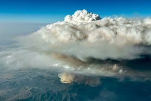
Scientists operating as part of NASA’s Injected Smoke and Pyrocumulonimbus Experiment (INSPYRE) campaign achieved a rare feat in atmospheric observation this summer, capturing detailed imagery of an ephemeral pileus cloud perched atop a towering, smoke-infused pyrocumulus cloud generated by the Sand Creek wildfire in Montana. The observation, made during an August 11, 2026, research flight, provides unprecedented insight into the extreme atmospheric dynamics driven by intense wildfires and underscores the critical role of airborne scientific missions in unraveling complex Earth system processes. This singular event, occurring high above the active inferno, offers a vivid illustration of how terrestrial events can dramatically sculpt the atmosphere, creating transient but scientifically significant phenomena.
Unveiling a Rare Atmospheric Spectacle
The primary objective of the INSPYRE campaign is to study the colossal, smoke-laden clouds that wildland fires often spawn, particularly pyrocumulonimbus (pyroCb) clouds, which can inject smoke and aerosols high into the stratosphere, influencing atmospheric chemistry and climate patterns on a global scale. However, the August 11 flight over the Sand Creek fire yielded an unexpected bonus: a perfectly formed pileus cloud, often referred to as a "cap cloud," hovering distinctively over the vigorous updraft of the fire-generated cloud.
Pileus clouds, derived from the Latin word for "cap" or "felt hat," are smooth, lenticular-shaped clouds that form when a strong, rapidly rising air current – typically associated with vigorous convection from thunderstorms, volcanic eruptions, or, in this rare instance, intense wildfires – pushes a layer of stable, moist air upward. As this moist air is forced aloft, it cools rapidly due to adiabatic expansion, and its water vapor condenses, forming the characteristic veil-like cloud. While familiar to atmospheric scientists and cloud enthusiasts as indicators of powerful convection, observing a pileus cloud in such detailed interaction with a pyrocumulus cloud (pyroCu) is exceedingly rare and provides invaluable data for researchers.
Neil Lareau, the deputy project investigator for INSPYRE, articulated the significance of the observation: "We rarely see a pileus cloud interacting with a fire cloud in this much detail. It’s akin to witnessing a mountain forming instantaneously in the sky, with the pyrocumulus itself acting as the ‘mountain’ forcing the air upwards." He elaborated that the process mirrors the orographic lifting that creates clouds as air flows over mountain ranges, but here, the intense heat and vertical displacement generated by the wildfire provided the necessary lift.
The INSPYRE Campaign: A Deeper Look into Fire-Atmosphere Interactions
The INSPYRE mission, spearheaded by NASA, is a multi-agency effort designed to comprehensively study the atmospheric impacts of wildfires. Launched in the summer of 2026, the campaign utilizes a suite of advanced airborne instruments on high-flying research aircraft, such as NASA’s ER-2, to intercept and analyze smoke plumes and fire-generated clouds. The overarching goal is to understand how these events influence regional weather, climate, and air quality, a concern that has grown significantly with the increasing frequency and intensity of wildfires across the globe.
"The observations from the Sand Creek fire are, in many ways, the core of what we’re after with INSPYRE," Lareau stated. "We were able to connect and map the surface fire dynamics to the convective plume to the cloud processes. This comprehensive data set allows us to build more accurate models of fire behavior and atmospheric responses." The campaign collects data on various aspects of fire plumes, including their chemical composition, particle size distribution, and the meteorological conditions that foster their development and vertical transport. This includes assessing the radiative properties of smoke aerosols and their potential to either warm or cool the atmosphere, depending on their altitude and composition.
The ER-2 aircraft, a modified version of the U-2 spy plane, is an ideal platform for such research due to its ability to fly at altitudes above 65,000 feet (approximately 20 kilometers) for extended periods. This allows instruments to observe the entire vertical extent of large smoke plumes and cloud systems from above, providing a synoptic view not possible from ground-based observations or lower-flying aircraft. Its endurance and high-altitude capabilities are crucial for tracking evolving phenomena like pyrocumulus and pileus clouds, which can develop and dissipate rapidly.
The Sand Creek Fire: Context for a Unique Observation
The Sand Creek fire, located in a remote and rugged part of Montana, had been burning for several weeks by the time of the August 11 observation. Like many wildfires across the Western United States in the summer of 2026, it exhibited periods of intense activity fueled by dry conditions, high temperatures, and shifting winds. On the day of the observation, the fire was particularly active, making a "rapid run up the western side of Mount Comet," as described by Lareau. This intense surface behavior, combined with favorable atmospheric conditions, generated the powerful updraft necessary for the formation of the pyrocumulus cloud.
The 2026 wildfire season in Montana and the wider Western U.S. had been particularly challenging, characterized by prolonged droughts and record-breaking heatwaves. These conditions prime forests and grasslands for ignition and facilitate the rapid spread of fires, often leading to the formation of large, energetic plumes capable of reaching significant altitudes. The Sand Creek fire was one of several incidents that contributed to widespread smoke impacts across the region, affecting air quality in communities hundreds of miles away. Understanding the vertical transport of this smoke, especially when injected into the upper troposphere or stratosphere by pyroCb events, is a key focus for air quality forecasters and climate scientists alike. The formation of a pileus cloud over such an event signifies an extreme example of this energetic vertical transport.
Advanced Imaging and Data Acquisition
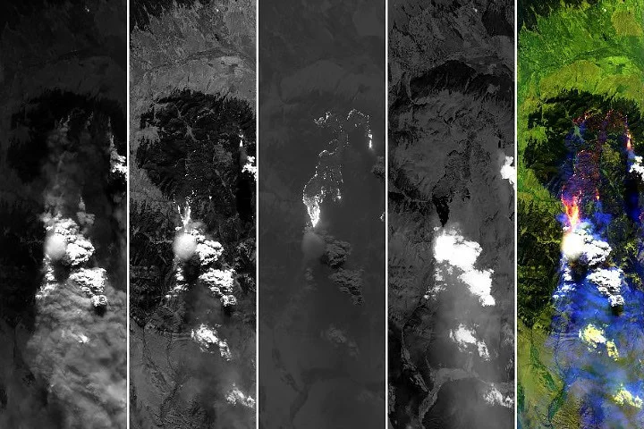
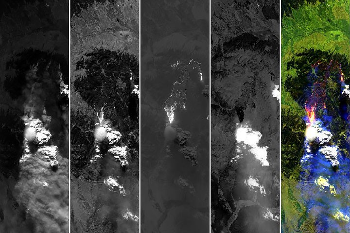
The pair of images capturing the pileus cloud was acquired at 5:40 p.m. local time (23:40 UTC) by the MODIS/ASTER Airborne Simulator (MASTER) instrument onboard NASA’s ER-2. MASTER is a sophisticated imaging spectrometer designed to simulate data from the MODIS and ASTER satellite instruments, providing high-resolution, multi-spectral data across 50 channels, or bands, ranging from visible to thermal infrared wavelengths. This wide spectral coverage allows scientists to distinguish between different atmospheric constituents, surface features, and active fire zones.
The natural-color image (similar to the visible channels) vividly depicted the thin, circular pileus cloud delicately capping the turbulent turret of smoke and water vapor rising from the wildfire. The simultaneous shortwave-infrared (SWIR) observations, however, offered an even deeper layer of information. SWIR bands are particularly adept at penetrating smoke to reveal the ground beneath and are highly sensitive to thermal anomalies, making them invaluable for mapping burned areas and identifying actively burning spots along a fire’s perimeter. This combination of visible and infrared data allowed researchers to precisely correlate the atmospheric phenomenon with the intensity and location of the fire on the ground.
The ephemeral nature of pileus clouds makes their detailed observation a matter of fortunate timing. Lareau noted that while MASTER captured imagery of the plume roughly every 30 minutes, the pileus was clearly visible in only one scene, underscoring the fleeting character of such events. This highlights the importance of persistent monitoring and flexible mission planning inherent in campaigns like INSPYRE, which can respond rapidly to evolving atmospheric conditions and fire behavior. The ability of MASTER to capture both the visible cloud structure and the underlying fire’s thermal signature simultaneously was crucial for connecting the extreme surface activity to the powerful updraft dynamics observed aloft.
Scientific Significance and Mechanism
The observation of a pileus cloud atop a pyrocumulus is more than just a beautiful image; it’s a powerful scientific data point. It confirms the presence of "extreme updraft dynamics" within the fire plume, as described by Lareau. These updrafts are responsible for lofting massive quantities of smoke, ash, and gases high into the atmosphere, often reaching the lower stratosphere. The vigorous convection heats the air, making it buoyant, and it rises rapidly. As this column of air ascends, it displaces the cooler, moister air layers above it. If a stable, moist layer exists at a certain altitude, the forced ascent and subsequent cooling of this displaced air will lead to condensation and the formation of the pileus.
The Sand Creek observation provides empirical evidence for the specific meteorological conditions conducive to such events within a wildfire context. Understanding these conditions is vital for improving atmospheric models, which currently struggle to accurately represent the complex interactions between large fires and the atmosphere. Improved modeling can lead to better predictions of smoke transport, air quality impacts, and even fire weather, potentially aiding in fire suppression efforts and public safety.
Moreover, the presence of a pileus cloud can be an indicator of a pyrocumulonimbus (pyroCb) event, which is a fire-driven thunderstorm. PyroCb clouds are of particular interest because they can inject smoke directly into the stratosphere, where aerosols can persist for much longer periods than in the troposphere, influencing global climate patterns. While the article does not explicitly state the Sand Creek pyrocumulus evolved into a full pyroCb, the extreme updraft indicated by the pileus suggests it was a very vigorous and potentially stratospheric-injecting event.
Broader Implications for Climate and Wildfire Science
The increasing frequency and intensity of large wildfires globally, exacerbated by climate change, make research like INSPYRE critically important. These fires are no longer just local disasters; they are significant drivers of atmospheric change. The ability to precisely measure and understand the processes within fire-generated clouds, including the rarer phenomena like pileus formation, is essential for predicting future climate scenarios.
"Every observation like this helps us refine our understanding of how wildfires perturb the Earth system," explained a hypothetical NASA spokesperson, emphasizing the agency’s commitment to Earth science. "As our planet warms and wildfire seasons intensify, these types of atmospheric interactions will likely become more common, making detailed studies like INSPYRE indispensable for developing effective mitigation and adaptation strategies."

The data collected by INSPYRE will contribute to a growing body of knowledge on aerosol-cloud interactions, which remain one of the largest uncertainties in climate modeling. Smoke particles from wildfires can act as cloud condensation nuclei, affecting cloud formation, reflectivity, and precipitation patterns. By observing the intricate dance between smoke, moisture, and updrafts in real-time, scientists can calibrate satellite observations and improve the fidelity of climate models.
Historical Context of Pileus Observations
While rare over wildfires, pileus clouds have been observed in other contexts of intense convection. They are most commonly associated with vigorous cumulus or cumulonimbus clouds (thunderstorms). Researchers participating in NASA’s CRYSTAL-FACE (Cirrus Regional Study of Tropical Anvils and Cirrus Layers-Florida Area Cirrus Experiment) in Honduras in 2002, for example, reported thin cirrus clouds in the tropopause above thunderstorms, which were likely the remnants or products of pileus clouds. These observations similarly underscored the power of strong updrafts to push moist air to great heights.
Volcanic eruptions also provide a dramatic backdrop for pileus cloud formation. One of the more iconic images captured by astronauts and published by NASA Earth Observatory depicts a pileus cloud majestically cloaking the top of a volcanic plume rising from the Sarychev volcano after an eruption in 2009. In this scenario, the explosive force of the eruption drives a column of superheated ash and gases upward, mimicking the powerful updraft of a wildfire or thunderstorm to create the same cap-like cloud feature. Each of these different contexts—thunderstorms, volcanoes, and now wildfires—reinforces the fundamental atmospheric principle of how strong vertical motion interacts with stable, moist air layers to create these transient, yet visually striking, meteorological phenomena.
Conclusion and Future Outlook
The exceptional observation of a pileus cloud over Montana’s Sand Creek fire on August 11, 2026, represents a significant moment for atmospheric science. It is a testament to the dedication of scientists and the advanced capabilities of NASA’s airborne research platforms like the ER-2 and its MASTER instrument. By meticulously connecting surface fire dynamics to the resulting convective plume and intricate cloud processes, the INSPYRE campaign is providing critical data that will undoubtedly enhance our understanding of fire-atmosphere interactions in an era of escalating wildfire activity. These insights are not merely academic; they are vital for improving forecasts, informing policy, and ultimately, safeguarding communities and ecosystems increasingly impacted by the changing climate and the fires it fuels. As wildfires continue to shape our landscapes and skies, missions like INSPYRE will remain at the forefront of deciphering their complex and far-reaching atmospheric consequences.