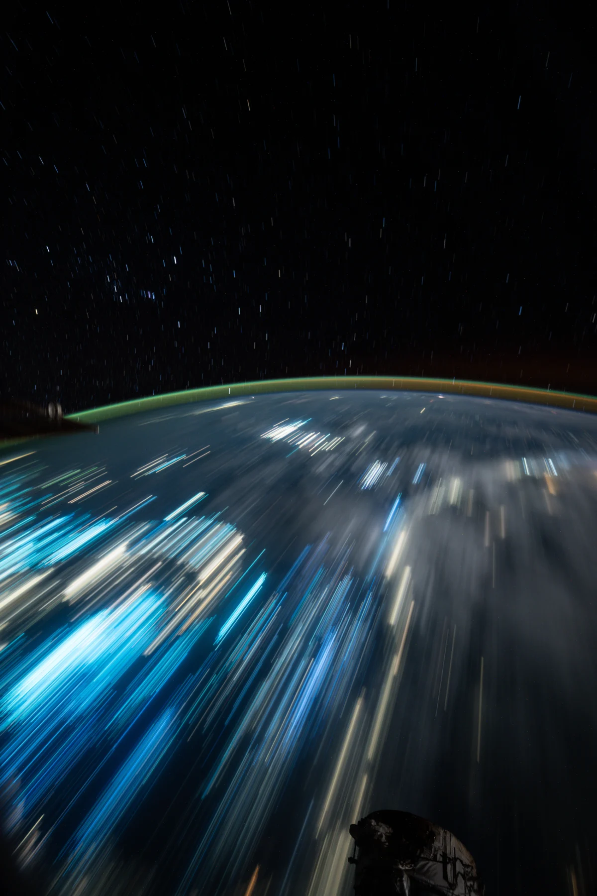
A remarkable long-duration exposure captured from the International Space Station (ISS) on September 20, 2026, has provided a breathtaking and scientifically rich panorama of Earth from an orbital perspective, revealing both celestial phenomena and profound evidence of human activity. The image, released by NASA on September 30, 2026, showcases the ethereal arcs of star trails against the blackness of space, juxtaposed with the vibrant blue illumination from countless fishing boats and the sprawling yellow light signatures of Indonesian cities, all stretching across the Banda Sea as the orbiting laboratory passed 258 miles above. Credited to NASA and astronaut Anil Menon, this striking photograph offers a unique visual record that merges astronomical beauty with a detailed snapshot of terrestrial ecosystems and human development.
The Art and Science of Orbital Astrophotography
The technique of long-duration exposure from the ISS is a sophisticated method employed by astronauts to capture the dynamic interplay between Earth and the cosmos. Unlike standard photographs, which freeze a moment in time, a long-exposure image accumulates light over an extended period, typically several minutes. From the ISS, which orbits Earth at approximately 17,500 miles per hour (28,000 km/h), this technique yields distinct results. The rapid motion of the station relative to the stars creates the characteristic star trails—streaks of light tracing the apparent movement of celestial bodies across the sky. These aren’t due to Earth’s rotation in the conventional sense observed from the ground, but rather the ISS’s own swift trajectory around the planet, causing stars to appear to move across the field of view during the exposure.
Astronaut Anil Menon, part of the current expedition aboard the ISS, utilized specialized camera equipment, likely a high-sensitivity digital single-lens reflex (DSLR) camera mounted on a stable platform within the Cupola module or another observation window. The Cupola, with its seven windows, offers an unparalleled panoramic view of Earth and space, making it an ideal vantage point for such intricate photographic endeavors. Achieving a clear, long-duration shot requires precise timing, a stable platform to minimize vibrations from the station’s internal systems, and often manual adjustments to compensate for changes in light conditions and the station’s attitude. The resulting image serves not only as an aesthetic marvel but also as a testament to the advanced capabilities of both human ingenuity and orbital technology.
A Glimpse into the Banda Sea’s Maritime Activity
The most prominent terrestrial feature in the image, aside from the urban lights, is the pervasive blue glow emanating from the Banda Sea. This intense illumination is attributed to the vast fleets of fishing boats operating in the region. The use of powerful blue lights by fishing vessels is a common practice, particularly in Southeast Asia, where it is employed to attract specific species of fish and squid. These lights, often high-intensity LEDs, penetrate the water column, drawing marine life closer to the surface where they can be more easily caught. The sheer density and widespread distribution of these blue lights visible from orbit underscore the scale of the fishing industry in this part of the world.
The Banda Sea, located in the eastern part of Indonesia, is renowned for its rich marine biodiversity and significant fishing grounds. It is part of the Coral Triangle, a global center of marine biodiversity, home to an extraordinary array of coral species, fish, and other marine organisms. The economic livelihoods of millions in Indonesia and neighboring countries are intimately tied to the productivity of these waters. Images like the one captured by astronaut Menon provide invaluable data for marine biologists, fisheries management experts, and environmental scientists. By mapping the distribution and intensity of fishing lights, researchers can gain insights into fishing patterns, assess the geographical extent of different fisheries, and monitor potential issues related to overfishing or unregulated activity. This satellite-level perspective offers a macro view that complements localized studies and helps inform sustainable management practices for a vital global resource.
Indonesian Urban Landscapes Illuminated
Stretching beneath the star trails and interspersed with the fishing lights are the distinctive yellow and orange glows of Indonesian cities. From 258 miles above, the distinct light signatures trace the contours of human habitation, revealing the intricate networks of urban development across the archipelago. While the specific cities are not explicitly named in the initial release, the Banda Sea region is surrounded by several significant population centers. Cities on islands such as Sulawesi, the Maluku Islands, and potentially parts of Papua could be contributing to the visible light pollution. Major cities like Makassar (on Sulawesi), Ambon (capital of Maluku province), and Manado (on Sulawesi) are substantial urban hubs whose nighttime illumination would be clearly discernible from space.
These urban lightscapes are more than just aesthetic patterns; they are proxies for population density, economic activity, and infrastructure development. The expansion of these illuminated areas over time, as documented by successive images from space, can be used to track urbanization rates, monitor energy consumption, and assess the spread of human impact on the natural environment. While city lights symbolize progress and human endeavor, they also contribute to light pollution, which has ecological consequences for nocturnal wildlife and astronomers alike. NASA’s Black Marble project, for instance, utilizes night lights data to understand human settlements and their dynamics. The image from September 20, 2026, contributes to this growing archive of data, offering a contemporary snapshot of Indonesia’s dynamic urban landscape as seen from a unique vantage point.
The International Space Station: A Beacon of Earth Observation
The International Space Station, a collaborative project involving five space agencies—NASA (United States), Roscosmos (Russia), JAXA (Japan), ESA (Europe), and CSA (Canada)—has been continuously inhabited since November 2000. Beyond its primary role as an orbiting laboratory for microgravity research, the ISS serves as a crucial platform for Earth observation. Astronauts aboard the station are trained to capture images and conduct scientific observations that contribute to a vast array of scientific disciplines, from meteorology and oceanography to geology and environmental monitoring.
The station’s unique orbit, inclined at 51.6 degrees to the equator, allows it to pass over approximately 90% of the Earth’s populated landmass. This broad coverage, combined with the presence of human observers who can react to dynamic events (like volcanic eruptions or hurricanes) and adjust camera settings, makes astronaut photography exceptionally valuable. The equipment used by astronauts often includes commercially available high-resolution cameras, but their expertise in identifying key features and optimal lighting conditions elevates their work beyond mere snapshots. The images they capture are routinely made available to the public and scientific community, inspiring future generations and providing critical data for scientists studying our changing planet. The photograph by Anil Menon is a prime example of this ongoing mission, illustrating how human eyes and advanced technology can combine to produce data-rich visual narratives of Earth.
Expert Perspectives and Broader Implications
The release of such an image invariably sparks interest across various scientific disciplines. Dr. Elena Petrova, a remote sensing specialist at the Global Observation Institute (a hypothetical institution for this article), noted, "This image is a fascinating confluence of data points. The distinct blue of the fishing lights is particularly valuable for maritime researchers. It allows us to visualize, at a glance, the scale of nocturnal fishing operations in a critical region like the Banda Sea. When combined with other satellite data, such as vessel tracking systems, it helps us understand fishing pressure and potential compliance issues." She added, "The urban lights, meanwhile, provide a snapshot of development and energy use, offering ground truth for models predicting urbanization trends and light pollution impacts."
From an astronomical perspective, Dr. Kenji Tanaka, an astrophotography expert (hypothetical), commented, "Capturing clear star trails from a fast-moving platform like the ISS is technically challenging. It requires precise understanding of orbital mechanics and camera settings. Astronaut Menon’s image beautifully demonstrates the relative motion of the station against the backdrop of distant stars, creating a unique visual that is distinct from ground-based astrophotography."
The implications of such imagery extend beyond scientific data collection. They serve as powerful tools for public engagement, fostering a sense of wonder and connection to our planet. Seeing Earth from space, adorned with both natural beauty and human markings, can heighten environmental awareness and inspire interest in science and space exploration. The ability to witness human impact—from sprawling cities to extensive fishing fleets—from an orbital vantage point provides a compelling, objective perspective on humanity’s footprint.
Looking Ahead: Continued Earth Observation and Scientific Return
As the International Space Station continues its mission into the late 2020s and beyond, Earth observation remains a cornerstone of its scientific agenda. Future expeditions will undoubtedly continue to capture similar, if not more advanced, imagery of our planet. These images, combined with data from dedicated Earth-observing satellites, contribute to a comprehensive understanding of global processes. For instance, time-series analysis of images showing fishing lights can help track changes in fisheries over seasons or years, providing insights into stock health and environmental shifts. Similarly, monitoring urban light expansion can inform studies on energy efficiency, infrastructure planning, and the socioeconomic development of regions.
The work of astronauts like Anil Menon, who skillfully blend scientific observation with artistic capture, underscores the multifaceted value of human presence in space. Their unique perspective provides data that no automated system can fully replicate, offering an intuitive understanding of Earth’s complex systems and humanity’s place within them. The image from September 20, 2026, stands as a vivid reminder of the beauty and intricate details that await discovery when we look at our home planet from a different point of view, reinforcing the ongoing importance of space exploration for both scientific advancement and global enlightenment.