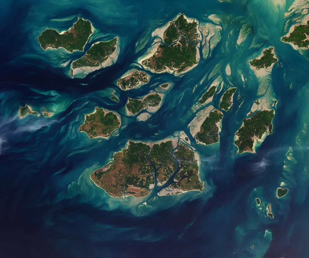
Twice each day, the colossal forces of the Atlantic Ocean orchestrate a dramatic transformation across the Bijagós Archipelago, an intricate network of 88 islands and islets off the coast of Guinea-Bissau. This perpetual ballet of ebb and flow, witnessed through a maze of sandy channels, expansive mudflats, and dense mangrove forests, profoundly redefines the landscape, causing islands to visibly "grow" and "shrink" with the rhythm of the tides. A striking satellite image captured on November 28, 2025, by instruments overseen by NASA and USGS, provided a compelling visual testament to this dynamic process, illustrating how vast intertidal mudflats and sandflats emerge from the sea at low tide, temporarily expanding the landmasses before receding hours later. This natural phenomenon not only shapes the physical geography but also underpins one of West Africa’s most biodiverse and ecologically significant coastal ecosystems, sustaining a unique array of wildlife and a vibrant indigenous culture.
The Bijagós Archipelago: A Geographical Overview
The Arquipélago dos Bijagós, as it is known in Portuguese, is situated approximately 60 kilometers (37 miles) offshore from the mainland of Guinea-Bissau, spanning an area of roughly 2,624 square kilometers (1,013 square miles). Comprising 88 islands, with about 20 permanently inhabited, the archipelago is characterized by its low-lying terrain, intricate estuarine systems, and a complex mosaic of habitats. The dominant geographical features are the extensive intertidal zones, which can stretch for several kilometers from the high-tide mark, revealing vast expanses of nutrient-rich mud and sand. These areas are critical ecological transition zones, acting as natural filters and nurseries for countless marine species.
The exceptional tidal amplitude in this region of West Africa is a primary driver of the archipelago’s dynamic nature. The difference between high and low tide can be substantial, often exceeding several meters, which allows for the periodic exposure and submergence of enormous areas of the seabed. During the twice-daily low tide, these previously submerged areas become exposed, revealing a transient landscape that supports specialized flora and fauna adapted to extreme fluctuations in salinity, temperature, and moisture. The channels, which appear as narrow waterways at high tide, transform into broad, muddy expanses, creating a constantly shifting environment that demands remarkable adaptability from its inhabitants. The satellite imagery from late 2025 underscored the sheer scale of this daily land-sea interplay, offering scientists a valuable data point for understanding coastal geomorphology and hydrodynamics in such high-energy tidal environments.
A Sanctuary of Unparalleled Biodiversity
The extreme tidal dynamics and the resulting intertidal zones are the cornerstone of the Bijagós Archipelago’s extraordinary biodiversity, earning it recognition as a UNESCO Biosphere Reserve since 1996. This status highlights its global importance for both natural and cultural heritage.
Mangrove Ecosystems: The extensive mangrove forests are perhaps the most visually prominent and ecologically vital habitats within the archipelago. Dominated by species such as red mangrove (Rhizophora racemosa), black mangrove (Avicennia germinans), and white mangrove (Laguncularia racemosa), these coastal woodlands thrive in the brackish waters and nutrient-rich muds of the intertidal zone. Mangroves are critical for coastal protection, acting as natural buffers against erosion, storm surges, and sea-level rise. Their intricate root systems stabilize sediments, filter pollutants, and provide essential nursery grounds for a multitude of fish, crustaceans, and mollusk species, many of which form the basis of local livelihoods. Estimates suggest that mangrove cover in the Bijagós is among the most extensive and pristine in West Africa, playing an indispensable role in the regional carbon cycle and climate regulation.
Marine and Avian Life: The productive waters surrounding the Bijagós support a rich diversity of marine life. Numerous species of fish, including barracuda, snapper, and grouper, frequent the mangrove-lined channels and offshore reefs. The archipelago is also a critical breeding ground for several species of marine turtles, notably green turtles (Chelonia mydas), loggerheads (Caretta caretta), and olive ridleys (Lepidochelys olivacea), which utilize the remote beaches for nesting. The vast mudflats and sandflats that emerge at low tide provide crucial foraging grounds for immense populations of migratory birds. The Bijagós is a designated Ramsar site, a wetland of international importance, specifically due to its significance for Palearctic migratory waders and seabirds. Species like curlews, sandpipers, godwits, and various terns arrive in their hundreds of thousands during the non-breeding season, relying on the abundant invertebrate life exposed by the receding tides. Resident bird species, including numerous herons, egrets, and kingfishers, also thrive in this rich environment.
The Saltwater Hippos and Other Unique Species: One of the most iconic and ecologically distinct inhabitants of the Bijagós is a unique population of saltwater hippos (Hippopotamus amphibius). Unlike their freshwater counterparts found elsewhere in Africa, these hippos have adapted to forage in the estuarine waters and even venture into the sea, demonstrating remarkable physiological and behavioral adaptations to their coastal environment. This subpopulation is genetically distinct and represents a fascinating case study in evolutionary adaptation. Other notable mammalian residents include African manatees (Trichechus senegalensis), bottlenose dolphins (Tursiops truncatus), and various primate species inhabiting the forested islands. The archipelago’s isolation and unique environmental conditions have fostered a high degree of endemism and specialization, making it a natural laboratory for ecological and evolutionary research.
Cultural Heritage and Indigenous Stewardship
Beyond its ecological significance, the Bijagós Archipelago is equally renowned for its profound cultural heritage, centered around the Bijagó people. This indigenous community, numbering approximately 30,000 individuals, has maintained a unique way of life that is intricately woven into the fabric of their island environment. The Bijagó society is traditionally matriarchal, with women playing central roles in economic, social, and spiritual life. Their traditional governance systems, spiritual beliefs, and subsistence practices are deeply rooted in a sustainable relationship with the land and sea.
The Bijagó People and Their Traditions: The Bijagó people live in close harmony with the natural cycles of the archipelago. Their spiritual beliefs often center around a pantheon of spirits associated with specific islands, natural features, and ancestors. Sacred forests and sites are preserved, often acting as de facto conservation areas where human activity is restricted. Traditional ceremonies, often elaborate and vibrant, reinforce community bonds and respect for the natural world. Their housing, fishing techniques, and agricultural practices (primarily rice cultivation in flooded fields) are all adapted to the challenging tidal environment and the availability of resources.
Sustainable Practices: For centuries, the Bijagó people have practiced forms of resource management that align with modern conservation principles. Their traditional knowledge systems dictate sustainable harvesting of fish, shellfish, and forest products, ensuring that resources are not depleted. For instance, specific fishing grounds might be closed during breeding seasons, or certain areas designated as sacred and thus off-limits to exploitation. This long-standing tradition of stewardship has played a crucial role in preserving the archipelago’s biodiversity, demonstrating that human communities can coexist with and even enhance natural ecosystems through deeply ingrained cultural practices. The presence of the Bijagó people is thus not merely a cultural artifact but an active, living component of the archipelago’s ecological resilience.
Scientific Observation and Global Significance
The capture of the satellite image on November 28, 2025, by NASA and USGS platforms underscores the ongoing scientific interest in the Bijagós Archipelago. These Earth observation missions, often part of the NASA Earth Observatory initiative, utilize advanced satellite technology, such as the Landsat series (a joint program of NASA and USGS), to monitor environmental changes across the globe.
NASA’s Earth Observatory Role: The Earth Observatory’s mission is to share images and stories about Earth’s climate and environment, providing a visual and data-rich narrative of our planet’s ongoing transformations. Images like the one of the Bijagós are not just aesthetic; they are critical scientific tools. They allow researchers to:
- Map Coastal Dynamics: Track changes in shorelines, monitor erosion and accretion patterns, and quantify the extent of intertidal zones.
- Assess Habitat Health: Observe the spread or retreat of mangrove forests, detect changes in water quality, and identify areas of ecological stress.
- Monitor Climate Change Impacts: Provide baseline data against which future changes, such as sea-level rise and increased storm intensity, can be measured. The Bijagós, with its low-lying islands and extensive intertidal areas, is particularly vulnerable to the effects of a warming climate.
- Support Conservation: Offer visual evidence for conservation planning, helping identify critical habitats and monitor the effectiveness of protected areas.
Understanding Coastal Dynamics: The daily "growth" and "shrinkage" of the islands due to tidal action provides a natural laboratory for studying hydrodynamics and sediment transport in high-energy coastal environments. Scientists can analyze time-series satellite imagery to model tidal flow, sediment deposition, and the long-term geomorphological evolution of such complex deltaic and estuarine systems. This understanding is crucial not only for the Bijagós but also for coastal management strategies worldwide, particularly in regions facing similar challenges of dynamic coastlines and ecological vulnerability. The data gathered from these observations contribute to global efforts to understand the intricate interplay between oceanic forces, landforms, and living ecosystems.
Conservation Efforts and Emerging Challenges
Despite its protected status and the inherent resilience of its ecosystems, the Bijagós Archipelago faces a growing array of threats that jeopardize its unique biodiversity and cultural heritage.
UNESCO Biosphere Reserve Status: The designation as a UNESCO Biosphere Reserve in 1996 provided a framework for conservation and sustainable development. It aims to reconcile the conservation of biodiversity with its sustainable use by local communities. Several national parks and protected areas have been established within the archipelago, including the Orango National Park, João Vieira-Poilão Marine National Park, and Formosa Natural Park. These parks are critical for protecting key nesting sites for marine turtles, foraging grounds for migratory birds, and the habitats of the saltwater hippos.
Threats: Climate Change, Poaching, Development Pressures:
- Climate Change: The most pervasive long-term threat is climate change. Rising sea levels pose a direct existential threat to the low-lying islands and the extensive intertidal zones. Increased frequency and intensity of extreme weather events, such as storms and heatwaves, could devastate mangrove forests and nesting beaches. Changes in ocean temperature and acidity could also impact marine life, including coral reefs and fish populations.
- Illegal Fishing and Poaching: Despite protection efforts, illegal, unreported, and unregulated (IUU) fishing remains a significant problem. Large industrial trawlers operating illegally in Bijagós waters deplete fish stocks, damage sensitive habitats, and undermine the livelihoods of local artisanal fishers. Poaching, particularly for marine turtles, their eggs, and the saltwater hippos, continues to be a concern, driven by both local consumption and international illicit trade.
- Unsustainable Resource Extraction: While the Bijagó people traditionally practice sustainable resource use, growing population pressures and external economic influences can lead to unsustainable logging of mangroves for timber and fuelwood, overharvesting of shellfish, and improper waste disposal.
- Oil Exploration: The potential for offshore oil and gas exploration in the region poses a significant environmental risk. Accidental spills could have catastrophic impacts on the fragile coastal and marine ecosystems, contaminating mangroves, devastating marine life, and impacting human health and livelihoods.
- Tourism Development: While sustainable tourism offers economic opportunities, uncontrolled development can lead to habitat destruction, increased waste, and cultural degradation if not managed carefully and in consultation with local communities.
Collaborative Conservation Initiatives: Addressing these multifaceted challenges requires a collaborative approach involving the Guinea-Bissau government, international conservation organizations (such as the World Wide Fund for Nature – WWF, and the IUCN), local NGOs, and most importantly, the Bijagó communities themselves. Initiatives include:
- Strengthening marine protected area management and enforcement.
- Promoting sustainable fishing practices and empowering local fisheries co-operatives.
- Developing alternative livelihoods that reduce pressure on natural resources.
- Implementing climate change adaptation strategies, such as mangrove restoration projects.
- Supporting environmental education and awareness programs within local communities.
- Integrating traditional ecological knowledge into modern conservation plans.
Looking Ahead: Sustaining a Dynamic Paradise
The Bijagós Archipelago stands as a living testament to the power of natural forces and the intricate balance of ecosystems. The daily spectacle of land expanding and contracting with the tides is more than just a geographical curiosity; it is the engine that drives a globally significant biodiversity hotspot and sustains a unique human culture. The satellite imagery from November 2025 serves as a timely reminder of this dynamic environment and the ongoing need for vigilant monitoring and proactive conservation.
Future research will undoubtedly continue to leverage remote sensing technologies to track changes in the archipelago, providing crucial data for understanding the impacts of climate change and human activity. Continued investment in scientific studies, combined with robust policy frameworks and empowered local stewardship, will be essential to safeguard the Bijagós. The challenge lies in balancing the developmental aspirations of Guinea-Bissau with the imperative to protect this irreplaceable natural and cultural heritage. By recognizing the intrinsic value of its dynamic tides, its abundant biodiversity, and its resilient indigenous communities, the international community and the government of Guinea-Bissau can work together to ensure that the Bijagós Archipelago remains a vibrant, thriving paradise for generations to come, a testament to the enduring power of nature and the wisdom of sustainable coexistence.