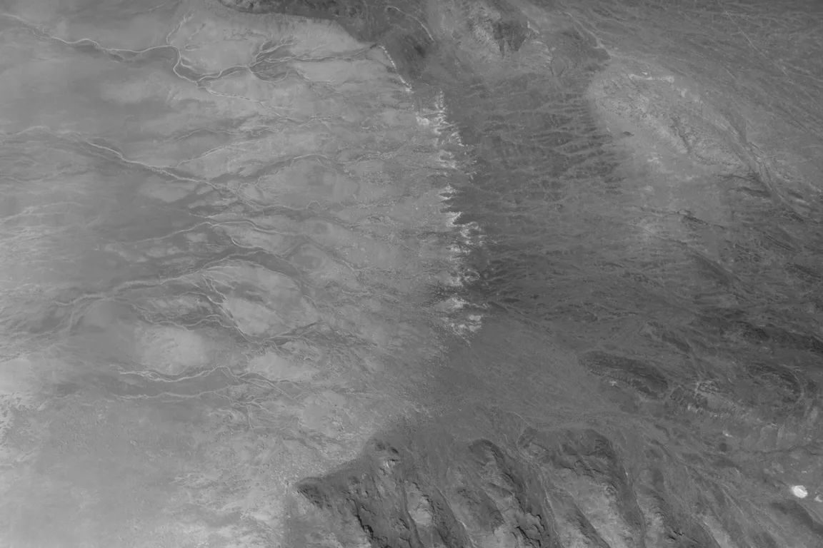
The vast, arid expanse of what was once ancient Lake Bonneville, captured in today’s Image of the Day, reveals a landscape sculpted by colossal geological forces and subsequently transformed into a crucible for human ambition and resilience. Stretching across western Utah and portions of Nevada and Idaho, this colossal Ice Age lake, once comparable in size to Lake Michigan, has receded over millennia, leaving behind expansive, luminous playas and salt flats. These mineral-rich surfaces have become the unlikely setting for feats of engineering and technological ingenuity, tales of exploration, and harrowing sagas of human desperation.
A Geological Chronicle: The Rise and Fall of Lake Bonneville
The genesis of Lake Bonneville dates back approximately 55,000 years ago, during the cooler, wetter climes of the late Pleistocene Epoch. This era of extensive glaciation provided the ideal conditions for the lake’s formation. A pivotal event in its early history was the diversion of the Bear River by ancient volcanic eruptions in what is now southeastern Idaho. This geological redirection caused an immense accumulation of water within Gem Valley and other basins to the south, initiating the growth of the prehistoric lake.
For tens of thousands of years, Lake Bonneville expanded, its waters contained by a natural geological dam at Red Rock Pass. At its zenith, the lake spanned an astonishing 32,000 square miles, boasting depths exceeding 1,000 feet in places and holding an estimated 12,000 cubic miles of water. To put this into perspective, Lake Michigan, one of the modern Great Lakes, covers roughly 22,404 square miles with an average depth of 279 feet and a maximum depth of 923 feet. Lake Bonneville was not merely large; it was a dominant hydrological feature that profoundly influenced the regional climate and ecology.
The lake’s long period of stability was abruptly shattered around 18,000 years ago. Geologists hypothesize that a combination of factors, possibly including seismic activity or prolonged overflow erosion, led to the catastrophic breaching of the Red Rock Pass dam. This event unleashed the Bonneville Flood, a torrent of epic proportions that ranks among North America’s largest floods. Over an estimated six-week period, an unimaginable volume of water surged northward, entering the Snake River and subsequently the Columbia River system. Lake levels plummeted by more than 350 feet (105 meters), with estimated flow rates potentially reaching 15 million cubic feet per second – a discharge comparable to that of the modern Amazon River. The Bonneville Flood dramatically reshaped vast stretches of land, carving canyons and depositing massive amounts of sediment hundreds of miles downstream.
Following this cataclysmic flood, as the global climate transitioned into the Holocene and became significantly warmer and drier, the remnants of Lake Bonneville underwent a dramatic and prolonged desiccation. This gradual shrinkage left behind a series of distinct geological features, most notably the "bathtub-like rings" and wave-cut terraces that clearly delineate former shorelines, etched into the landscape. Today, the enduring legacies of Lake Bonneville are the Great Salt Lake, Utah Lake, and Sevier Lake, each representing a different stage and characteristic of the ancient mega-lake. The Great Salt Lake, a hypersaline endorheic basin, is a stark reminder of the lake’s evaporative past, supporting a unique ecosystem of brine shrimp and millions of migratory birds.
A Canvas from Orbit: Satellite Views of a Vanished Sea

The enduring imprint of Lake Bonneville is strikingly evident from space, as showcased in the image captured by the Operational Land Imager (OLI) on the NASA-USGS Landsat 8 satellite. The satellite imagery vividly displays the aforementioned "bathtub-like rings," which are not merely lines but distinct geological formations representing successive ancient shorelines. These terraces, formed by wave action and sediment deposition at different lake stands, provide invaluable data for geologists studying paleoclimates and the history of large water bodies.
The dried lakebed itself presents a stark contrast to its surroundings. Composed of fine-grained clay, marl, and sandy sediment that settled out of the water over millennia, it appears notably pale in the satellite images. This light coloration is indicative of its mineral composition, primarily carbonates and silicates. In contrast, the surrounding, geologically older, and often more vegetated mountainous terrain appears darker and more rugged. This visual distinction allows scientists to precisely map the extent and stages of the ancient lake, offering a window into a dynamic past.
Mineral-Rich Playas and Economic Significance
Within the deepest parts of the Bonneville basin, where runoff and groundwater continue to pool and evaporate, a distinct phenomenon unfolds: the formation of vast salt flats. Here, bright deposits of evaporite minerals coat the land surfaces, creating some of the flattest natural areas on Earth. This process involves the gradual evaporation of water, leading to the concentration of dissolved minerals into brines, which then precipitate out to form hard mineral crusts. These crusts typically comprise common salts like halite (rock salt) and gypsum, alongside more complex potassium- and magnesium-bearing salts.
These mineral-rich deposits have long rendered the playas a significant target for industrial mining operations. Potash, a potassium-rich salt, is particularly valuable for its use as a vital agricultural fertilizer. The satellite imagery often reveals the distinct geometry of rectangular evaporation ponds, a clear sign of active mining. These operations are a significant economic driver for Utah, contributing to global agricultural supply chains. However, managing these resources also involves careful environmental considerations, balancing economic benefit with the preservation of the unique playa ecosystem and hydrological balance.
Mountains of Time: The Surrounding Geology
Rising dramatically above the pale playas are rugged mountain ranges that stand as ancient sentinels. Peaks like the Silver Island Mountains, the Newfoundland Mountains, and the Pilot Range are composed of layers of erosion-resistant sedimentary and metasedimentary bedrock, some dating back hundreds of millions of years. These ancient formations tell a story of vast shallow oceans and continental shifts. Interspersed within these older layers are younger igneous and metamorphic rocks, formed when molten magma intruded into the existing sedimentary sequence, a testament to periods of intense geological activity.
Crater Island, specifically highlighted in the context of NASA’s recent fieldwork, offers a microcosm of this complex geological tapestry. Its composition includes silica-rich sandstones and quartzites, originally formed as sands accumulated in ancient shallow oceans. Subsequent intrusions of quartz monzonite, granites, and other igneous rocks further complicate its structure. The broader landscape, including Crater Island, was profoundly shaped by periods of crustal stretching. This tectonic process led to the formation of characteristic fault-block mountains, where blocks of crust are uplifted (horsts) and down-dropped (grabens), defining the iconic Basin and Range province of the western United States.
NASA’s Venusian Analog on Earth: The DAVINCI Mission Field Test
In June 2026, Crater Island became an unexpected proving ground for humanity’s ambitions beyond Earth, serving as a critical field test site for NASA’s DAVINCI (Deep Atmosphere Venus Investigation of Noble gases, Chemistry, and Imaging) mission. Scientists and engineers designated Crater Island as "Venus on Earth" due to its geological similarities to regions on Venus, particularly Alpha Regio, a target for future exploration. The mission’s overarching goal is to understand the enigmatic planet Venus, which, despite its proximity, remains largely shrouded by a thick, hot, and corrosive atmosphere. DAVINCI seeks to unravel Venus’s atmospheric chemistry, its geological history, and why it evolved into a runaway greenhouse world so different from Earth, despite similar starting conditions.
During the field tests, a set of cameras and a sophisticated package of instruments, destined to descend through Venus’s dense atmosphere, were suspended from a helicopter. The simulation involved a 60-minute descent, mirroring the harrowing journey the actual probe will undertake. The instruments, including the DAVINCI Imager for Navigation, Geologic, and Atmospheric Sensing (DISC) camera system and the Venus Analytical Laboratory (VAL) payload, were tasked with capturing near-infrared images and measuring atmospheric chemistry, aiming to characterize the Venusian environment in unprecedented detail.
The rehearsal at Crater Island was a resounding success. The camera system captured hundreds of images of various rock formations, including both iron-rich and silica-rich units, as the helicopter carefully descended. Crucially, using only the images acquired by DAVINCI’s camera systems, the team was able to construct three-dimensional geological maps of the area. These maps proved remarkably consistent with existing, thoroughly surveyed geologic maps of Crater Island.
"The successful field tests at Crater Island are a crucial step forward for DAVINCI," stated a NASA spokesperson following the exercise. "We’ve demonstrated our ability to characterize complex geology in an extreme environment, giving us immense confidence in our upcoming mission to Venus’s Alpha Regio. This ‘Venus on Earth’ training has been invaluable in refining our instruments and techniques." This achievement provides NASA scientists with significant confidence that they will be able to accurately map the geology of Alpha Regio, an ancient highland region on Venus, despite the challenges of its thick atmosphere. Understanding Venus’s surface composition and geological history is vital for piecing together its evolutionary puzzle and understanding planetary habitability in general.
The Thrill of Speed: Bonneville’s Legendary Salt Flats
Beyond scientific exploration, the remarkably flat, smooth surfaces of the Bonneville Salt Flats have long served as the ultimate proving ground for human speed and engineering. Their unique properties – a vast, featureless expanse offering unparalleled traction – have drawn daredevils and innovators for over a century, transforming the ancient lakebed into a global mecca for land speed record attempts.
Among the legends forged here is Mickey Thompson. In 1960, driving his custom-built, streamlined "Challenger 1" race car, Thompson became the first American to shatter the formidable 400-miles-per-hour (640 kilometers-per-hour) barrier, hitting a blistering 406.60 miles per hour (654.36 kilometers per hour). This monumental achievement temporarily earned him the moniker "fastest man on Earth" and cemented his legacy as an icon of American motorsports and automotive engineering. Thompson’s relentless pursuit of speed pushed the boundaries of vehicle design and driver courage, inspiring generations of speed enthusiasts.
More recently, in August 2026, the Bonneville Salt Flats witnessed another historic moment as Andy Green, already famous as the first person to break the sound barrier on land (in 1997 with the ThrustSSC), set a new world record. This time, Green piloted a hydrogen-fueled internal-combustion vehicle to an astonishing 406.320 miles per hour (653.909 kilometers per hour). This achievement is particularly significant not just for its raw speed, but for its technological innovation and environmental implications. By burning hydrogen instead of traditional gasoline, Green’s "rocket car" produced zero carbon dioxide emissions, showcasing the immense potential of sustainable fuels in high-performance applications. "This record isn’t just about speed; it’s about demonstrating the immense potential of hydrogen power for future high-performance applications," stated a representative from Green’s team. "Bonneville continues to be the ultimate proving ground for automotive innovation, and we’re proud to have pushed the boundaries of sustainable speed." This record underscored a growing trend in motorsports to integrate environmental responsibility with the relentless quest for performance.
A Perilous Path: The Donner-Reed Party’s Ordeal
Almost two centuries before Andy Green’s groundbreaking run, in August 1846, the very same landscape near Crater Island bore witness to a far more desperate human endeavor: the passage of the ill-fated Donner-Reed Party. As part of their arduous journey westward on the California Trail, the emigrants, seeking a shortcut, chose to follow what was known as Hastings Cutoff. This supposed shortcut, touted by Lansford Hastings, promised to shave hundreds of miles off the traditional route but proved to be a tragic miscalculation.
The party journeyed from Hastings Pass, past Floating Island, and toward Donner Spring, directly traversing the southern edge of Crater Island and the Bonneville Salt Flats. What they encountered was a treacherous landscape that quickly turned their hopes into despair. Their heavy wagons, laden with supplies and families, broke through the thin, deceptive salt crust, sinking deep into the underlying, viscous mud. This unforgiving terrain brought their progress to a grinding halt, forcing them to spend precious days and weeks extracting their vehicles. The physical toll was immense, but the psychological impact of being mired in the vast, desolate landscape, with dwindling supplies and time, was even greater.
The delay proved catastrophic. Faced with impossible conditions and the need to lighten their load, the party was compelled to abandon several wagons and many of their vital possessions in the desert. This early ordeal on the Bonneville Salt Flats served as an ominous harbinger of the greater challenges to come. The significant delays and loss of crucial supplies directly contributed to their later entrapment by heavy snows in the Sierra Nevada mountains, culminating in one of the most tragic and desperate episodes in American westward expansion. The salt flats, in this instance, were not a stage for triumph, but a relentless, unforgiving obstacle that foreshadowed a harrowing fight for survival.
Broader Impact and Enduring Legacy
The ancient bed of Lake Bonneville, with its vast playas and towering, ancient mountains, continues to be a landscape of profound significance. It is a testament to the immense power of geological processes, a living laboratory for understanding planetary evolution, and a canvas upon which humanity continues to paint stories of ambition, technological prowess, and enduring struggle. From NASA’s preparations for exploring distant Venus to the relentless pursuit of speed records and the somber echoes of historical tragedies, the Bonneville region embodies a unique confluence of natural grandeur and human drama. This ancient, now arid, basin consistently challenges our limits, inspires our innovations, and reminds us of the profound connections between Earth’s deep past and our future aspirations.