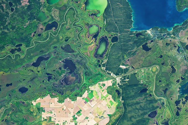
Satellite imagery from NASA-USGS Landsat missions has provided a compelling visual narrative of the 2026 growing season in Manitoba’s northernmost agricultural region, the Carrot River Valley, illustrating a dramatic transition from vibrant green vitality in early summer to the muted browns of harvest readiness by autumn. This unique agricultural "island," nestled within the expansive Saskatchewan River Delta west of The Pas, represents a testament to human ingenuity and resilience in cultivating productive farmland amidst challenging wetland environments. The images, captured on July 2 and September 21, 2026, by the Operational Land Imager (OLI) aboard Landsat 9 and Landsat 8 satellites respectively, offer a crucial perspective on the seasonal rhythms and persistent environmental management efforts defining this vital Canadian agricultural frontier.
The Northern Agricultural Frontier: Carrot River Valley’s Unique Position
The Carrot River Valley, formally known as the Pasquia Area Settlement, constitutes Manitoba’s most northerly agricultural zone. Spanning over 40,000 hectares (approximately 100,000 acres) within the Rural Municipality of Kelsey, this fertile expanse is bordered by the Carrot and Pasquia rivers, both significant tributaries of the Saskatchewan River. Its existence as a distinct farming region is particularly remarkable given its location within the Saskatchewan River Delta, one of North America’s largest inland deltas. Much of this vast delta, characterized by its intricate network of winding channels, myriad lakes, and extensive marshes, is naturally too saturated to support widespread agricultural activity. Yet, the Carrot River Valley emerges as a striking anomaly—a meticulously managed landscape of straight-edged fields that sharply contrasts with the curvilinear, untamed contours of the surrounding wetlands, including the ecologically rich Saskeram Wildlife Management Area to its north. This geographical paradox underscores the immense effort invested in transforming and sustaining arable land in an otherwise water-dominated ecosystem.
A Season in Focus: The 2026 Growing Cycle Unveiled by Satellites
The 2026 growing season in the Carrot River Valley presented its own set of characteristic challenges and subsequent successes, vividly documented by the Landsat satellites.
-
Early Challenges and Resilience (Spring/Early Summer): The agricultural year began with significant hurdles, as planting in the Northwest crop reporting region of Manitoba, which includes the Carrot River Valley, experienced delays compared to areas further south. This postponement was primarily attributed to persistent wet conditions during the critical spring planting window. Farmers in the region faced the familiar struggle of saturated fields, impacting their ability to sow crops on schedule. However, the region’s inherent agricultural advantages soon came into play. The fertile, alluvial soils, deposited over millennia by the Saskatchewan River and its tributaries, provide a rich foundation for vigorous plant growth. Coupled with the extended daylight hours characteristic of northern latitudes during the summer months, crops demonstrated a remarkable capacity for rapid development once conditions allowed for planting. This resilience is a hallmark of northern farming, where producers adapt to shorter, intense growing seasons.
-
Mid-Season Vibrancy (July 2): The Landsat 9 image from July 2, 2026, vividly depicted the valley at the zenith of its mid-season vitality. The landscape was a mosaic of lush green, indicating healthy, actively growing crops across the majority of the fields. This verdant expanse was a clear sign that, despite the initial delays, the favorable summer conditions—ample sunlight, warmth, and sufficient moisture—had allowed the crops to flourish, pushing towards their full growth potential. This snapshot captures the peak photosynthetic activity, a crucial period for yield development for staple crops like canola and spring wheat.
-
Autumnal Transformation and Harvest Progress (September 21): By late September, the satellite perspective had undergone a dramatic "flip." The Landsat 8 image from September 21, 2026, revealed a landscape predominantly transformed to shades of brown and gold, signaling crop maturity and the commencement of harvest operations. This autumnal shift is a natural progression as plants senesce, channeling energy from their foliage into the seeds or grains. According to a Manitoba Agriculture crop report issued around September 22, 2026, harvest progress across the Northwest region showed approximately 10 percent of canola and 50 percent of spring wheat had already been gathered. While The Pas area itself recorded minimal rainfall in the preceding week (a mere 1.6 millimeters, or 0.06 inches), which would typically aid harvest, wetter weather systems elsewhere in the Northwest region (up to 43.9 millimeters, or 1.7 inches) had caused delays for some producers. This contrast highlights the localized nature of weather patterns and their profound impact on agricultural logistics, where a few dozen kilometers can mean the difference between clear skies for combining and waterlogged fields halting operations.
The Lifeline of Data: Satellite Monitoring and Crop Inventories
The insights gleaned from the Carrot River Valley’s 2026 growing season are a testament to the indispensable role of advanced Earth observation technologies. The NASA-USGS Landsat program, with its decades-long legacy of continuous Earth imaging, provides critical data for monitoring agricultural health and land use change on a global scale. The Operational Land Imager (OLI) on both Landsat 8 and Landsat 9 captures high-resolution, multispectral images, allowing scientists and agricultural experts to differentiate between various crop types, assess plant vigor, and track seasonal phenological changes.
These satellite data feeds directly into vital resources like the Agriculture and Agri-Food Canada (AAFC) annual crop inventory. This comprehensive inventory, although the 2026 map had not yet been released by late September, is a cornerstone for agricultural planning, policy development, and market analysis. It provides detailed spatial information on crop types and distribution across the country, aiding in everything from yield forecasting to understanding regional agricultural trends. The 2025 AAFC map for the Carrot River Valley indicated that farmers primarily cultivated canola and spring wheat, alongside smaller, yet significant, patches of specialty crops such as Canary seed. Canola, a major Canadian export, is valued for its oil, while spring wheat is a fundamental component of the global food supply. Canary seed, though a niche crop, offers diversification and can thrive in certain northern conditions. The consistency in crop choices year-over-year reflects the established suitability of these crops to the region’s climate and soil, as well as prevailing market demands.
Battling the Waters: A Legacy of Engineering and Management
The very existence and productivity of the Carrot River Valley’s farmland are intrinsically linked to a long history of sophisticated water management and engineering. The natural propensity of the Saskatchewan River Delta to be "too wet" for extensive farming necessitated transformative interventions. In the 1950s, a major flood control and drainage project was initiated in the region. This ambitious undertaking involved the construction of extensive dike systems, drainage canals, and pumping stations designed to reclaim and protect arable land from the perennial threat of flooding by the Carrot and Pasquia rivers, as well as the broader deltaic waters.
This monumental project fundamentally altered the hydrological dynamics of the area, making large-scale agriculture feasible. Today, farming in the Carrot River Valley remains utterly dependent on these established diking and pumping infrastructures. These systems require continuous maintenance and significant investment to ensure agricultural flood protection. They represent a perpetual battle against nature, where human engineering constantly works to manage water levels, preventing both inundation during high-water periods and ensuring adequate drainage for optimal crop growth. The success of this region’s agriculture is a testament to the enduring legacy of this engineering marvel, highlighting the extent to which human intervention has shaped and sustained this northern food basket.
The Saskatchewan River Delta: An Ecological and Agricultural Paradox
The broader context of the Saskatchewan River Delta further amplifies the unique status of the Carrot River Valley. This delta is a globally significant wetland ecosystem, renowned for its incredible biodiversity. It serves as a critical habitat for countless species of waterfowl, fish, and other wildlife, and plays a vital role in the migratory bird flyways of North America. The ecological services provided by such a vast wetland—including water filtration, flood attenuation, and carbon sequestration—are immense.
However, the intensive agricultural practices within the Carrot River Valley present a delicate balance with this surrounding natural environment. While the diking and drainage systems protect farmland, they also alter natural water flows and can have implications for the delta’s hydrology and ecology. Organizations managing areas like the Saskeram Wildlife Management Area constantly strive to maintain the health of the wetland ecosystem, often in close proximity to the farmed landscapes. This coexistence necessitates careful environmental stewardship, sustainable land use practices, and ongoing dialogue between agricultural interests and conservation efforts to mitigate potential negative impacts and ensure the long-term health of both the agricultural land and the invaluable natural delta.
Perspectives from the Ground and Policy Makers
The narrative of the Carrot River Valley is not just one of satellite images and scientific data; it is deeply rooted in the efforts of local farmers and the supportive framework provided by provincial agricultural bodies.
-
Farmers’ Adaptations: Farmers in the Carrot River Valley are highly skilled practitioners of adaptive agriculture. They consistently make decisions based on real-time weather conditions, soil moisture levels, and market trends. Their choice of robust, cold-tolerant crops like canola and spring wheat, combined with strategic use of drainage and irrigation (where necessary), reflects a deep understanding of their unique environment. The delayed planting in 2026, followed by a successful mid-season recovery, showcases their ability to respond to and overcome climatic variability. These producers are at the forefront of northern agricultural innovation, integrating modern farming techniques with generations of localized knowledge.
-
Manitoba Agriculture’s Role: Manitoba Agriculture plays a crucial role in supporting these farmers. Through its crop reporting regions and regular updates, the department provides essential information on planting progress, crop conditions, pest pressures, and harvest status. These reports, such as the one detailing the 2026 harvest progress, are vital tools for farmers to plan their operations and for policymakers to understand the state of provincial agriculture. The department also provides advisory services, research, and support for water management infrastructure, recognizing the strategic importance of regions like the Carrot River Valley to Manitoba’s overall agricultural output and economy.
-
Environmental Stewardship: While not directly quoted, environmental agencies and local conservation groups are likely engaged in ongoing monitoring and advocacy for sustainable practices within the Saskatchewan River Delta. Their perspectives often emphasize the need for integrated watershed management, ensuring that agricultural productivity does not come at the undue expense of wetland health, water quality, and biodiversity. Discussions around enhancing natural water retention, improving drainage efficiency, and promoting ecologically friendly farming methods would be central to their engagement.
Broader Implications: Food Security, Economy, and Climate Resilience

The Carrot River Valley stands as a microcosm of broader trends and challenges facing northern agriculture in Canada and globally.
-
Economic Contribution: This agricultural area contributes significantly to Manitoba’s economy. The production of canola, spring wheat, and other crops generates substantial revenue, supports local businesses through supply chains (e.g., equipment sales, seed and fertilizer suppliers, grain elevators, transportation services), and provides employment opportunities within the Rural Municipality of Kelsey and surrounding communities. The value of these crops extends beyond local markets, contributing to Canada’s role as a major agricultural exporter.
-
Northern Agriculture in a Changing Climate: The region serves as an important indicator of the potential and perils of northern agriculture in an era of climate change. While longer growing seasons due to warming temperatures might open new opportunities for certain crops or increased yields, they also bring increased variability in precipitation, a higher risk of extreme weather events (such as intense rainfall or droughts), and shifts in pest and disease patterns. The persistent challenge of water management, evidenced by the 2026 wet spring and the historical need for extensive drainage, is likely to intensify with more unpredictable weather. The ongoing reliance on satellite monitoring and robust crop inventories will become even more critical for farmers to adapt and make informed decisions in a rapidly evolving climate.
-
Future Outlook: The future of farming in such marginal, yet productive, lands like the Carrot River Valley will hinge on continued innovation, adaptive management strategies, and a collaborative approach to land and water governance. Investments in climate-resilient infrastructure, research into new crop varieties suitable for changing conditions, and the integration of advanced agricultural technologies (e.g., precision farming, AI-driven analytics) will be crucial. The enduring story of the Carrot River Valley is one of human determination to harness the land’s potential, underscored by the scientific tools that allow us to observe, understand, and adapt to our planet’s ever-changing dynamics.
The seasonal transformation captured by Landsat satellites in Manitoba’s northernmost farmland near The Pas offers a powerful reminder of the intricate relationship between human agriculture, natural ecosystems, and the technological advancements that help us navigate their complexities. It is a story of resilience, adaptation, and the enduring quest to feed a growing world, even in the most challenging of environments.