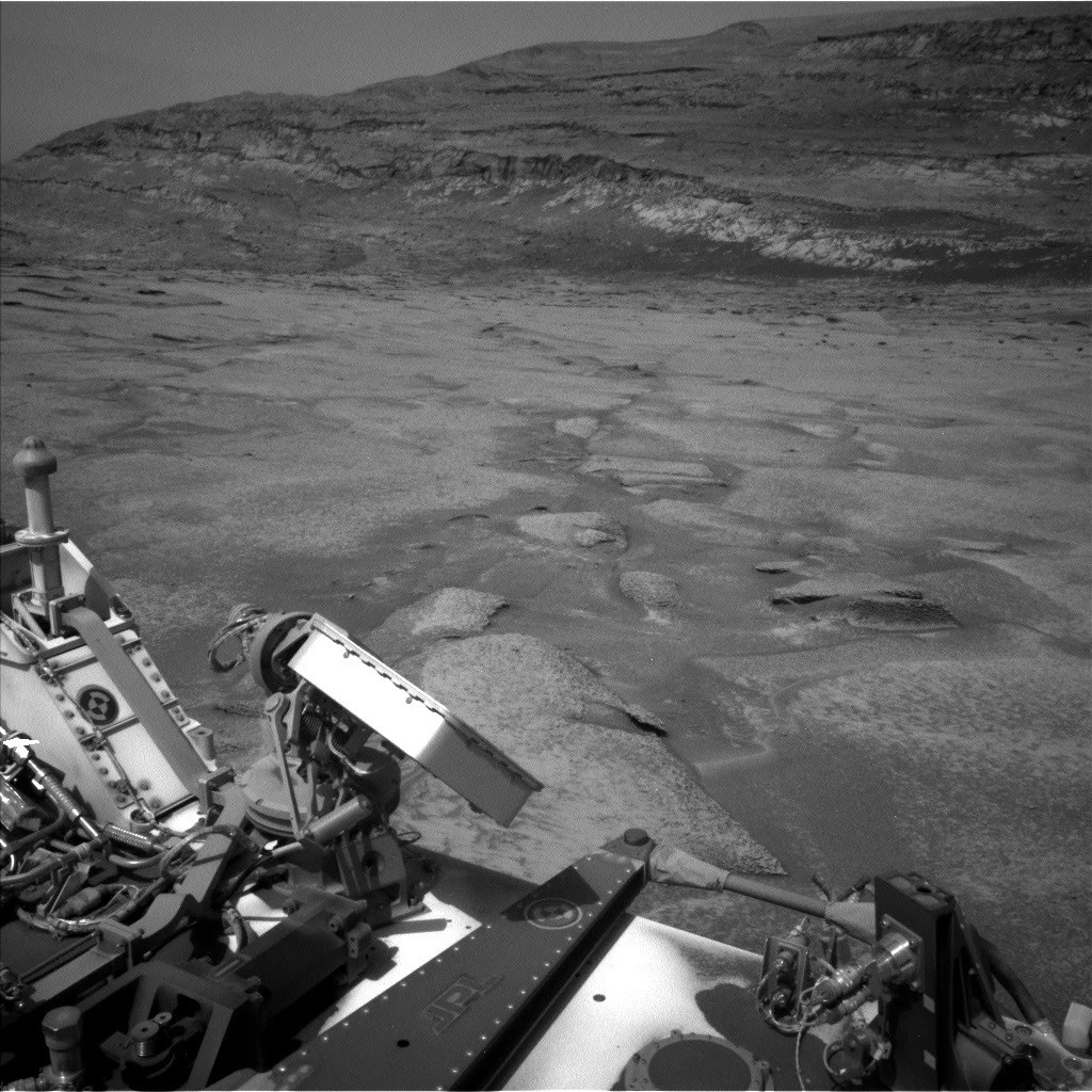
The Mars Science Laboratory (MSL) mission team is poised for a significant geological discovery as the Curiosity rover approaches a compelling feature on Mount Sharp identified as a possible "erosional supersurface." This past week, the rover meticulously prepared for an unprecedented close-up examination of this geological anomaly, which promises to unlock crucial insights into Mars’ ancient climate and sedimentary history. Located within the layered stratigraphy of Mount Sharp, this feature represents a distinct break in the planet’s rock record, signaling a period of significant regional erosion before subsequent deposition.
Curiosity’s Persistent Ascent of Mount Sharp: A Chronicle of Martian Change
Since its landing in Gale Crater in August 2012, the Curiosity rover has been systematically ascending the lower slopes of Mount Sharp (officially Aeolis Mons), a central peak rising approximately 5.5 kilometers (3.4 miles) above the crater floor. This towering geological formation serves as a monumental "strip chart" of Martian history, with each sedimentary layer offering clues about the planet’s past environmental conditions. The primary objective of the Mars Science Laboratory mission, led by NASA’s Jet Propulsion Laboratory (JPL), a division of Caltech, is to assess Mars’ past and present habitability, searching for evidence of environments that could have supported microbial life and characterizing the planet’s climate and geology.
Gale Crater itself is believed to be an ancient lakebed, and the layers of Mount Sharp are thought to have accumulated over millions of years, recording shifts in water presence, sediment transport, and atmospheric conditions. As Curiosity climbs higher, it encounters progressively younger geological strata, providing a chronological narrative of Martian evolution. The mission’s journey has already revealed compelling evidence of ancient lakes, rivers, and groundwater systems, firmly establishing that Gale Crater once hosted environments capable of supporting life as we know it. The discovery and subsequent investigation of features like the erosional supersurface are critical steps in refining this narrative.
Unveiling the "Erosional Supersurface": A Geological Anomaly Defined
The term "erosional supersurface" describes a geological phenomenon where extensive layers of sediment have been stripped away by wind or water on a regional scale before newer layers are deposited on top. On Earth, such features are known as unconformities, representing significant gaps in the geological record—periods where erosion, rather than deposition, was the dominant process. They are particularly common in aeolian (wind-blown) deposits, where shifting sands can create vast, undulating surfaces that later become buried. The presence of such a feature on Mars, specifically within the sedimentary layers of Mount Sharp, carries profound implications.
Scientists on the Mars Science Laboratory Mission Team first identified the possibility of this supersurface by analyzing orbital data, correlating subtle textural and topographic variations seen from space with images of the layers exposed in nearby buttes. Abigail Fraeman, Deputy Project Scientist at JPL, highlighted the significance, stating, "After eyeing this unusual section of Mount Sharp for the last few months, it’s exciting to finally be so close to this feature." For geologists, these surfaces mark a significant "break in the rock record," indicating a hiatus in continuous sedimentation and often signifying a dramatic shift in environmental conditions, such as prolonged periods of aridity, increased wind activity, or changes in water flow regimes. Understanding the composition and centimeter-scale geometry of this particular Martian supersurface will provide an unparalleled window into the forces that shaped the planet’s ancient landscape.
A Week of Intense Scientific Preparation: Data Collection and Analysis
The Earth planning date of Friday, July 24, 2026, marked a crucial phase in Curiosity’s approach to this intriguing geological boundary. The week’s activities were meticulously orchestrated to gather comprehensive data from various perspectives, ensuring that when the rover finally traverses the supersurface, the team will have a rich context for interpretation.
The initial strategy involved backing the rover away from the feature. This seemingly counter-intuitive maneuver was vital for acquiring a broad "rover’s-eye view" of the entire layer, enabling the team to plan subsequent, more detailed observations effectively. This strategic retreat set the stage for Monday’s intensive imaging campaign.
On Monday, Curiosity executed two "massive Mastcam mosaics" across the entire layer. The Mast Camera (Mastcam) is a pair of color cameras on the rover’s mast that can take high-resolution images and videos. These mosaics, stitched together from dozens or even hundreds of individual frames, provide a panoramic, high-definition view of the supersurface and its surrounding geological context. Such extensive imaging is crucial for understanding the macroscopic structure, layering, and any variations in color or texture that might indicate different geological processes or compositions.
Complementing Mastcam’s broad perspective, the Chemistry and Camera (ChemCam) instrument provided additional support by collecting long-distance Remote Micro-Imager (RMI) images of the most interesting areas of the supersurface. ChemCam, a versatile instrument, uses a laser-induced breakdown spectroscopy (LIBS) system to determine the elemental composition of rocks and soils from a distance, but it also features a high-resolution RMI camera. The RMI allows scientists to zoom in on specific targets, providing detailed textural information from several meters away, which is invaluable for identifying small-scale features that might be missed in broader Mastcam views.
Beyond imaging, the team also focused on compositional analysis of rocks located at the base of this surface. The Mars Hand Lens Imager (MAHLI) and Alpha Particle X-ray Spectrometer (APXS) were deployed to investigate a target named "Monte Darwin." MAHLI is a close-up camera, akin to a geologist’s hand lens, capable of taking microscopic images of rock and soil textures, revealing intricate details about their formation and alteration. APXS, positioned near MAHLI, irradiates the target with alpha particles and X-rays, then measures the energy of emitted X-rays to determine the elemental composition (e.g., iron, sulfur, magnesium, aluminum, silicon). Together, MAHLI and APXS provide a detailed understanding of the mineralogy and texture of the rocks immediately beneath the supersurface, offering clues about the environment in which they formed and how they might relate to the erosional event.
Further compositional data was gathered using ChemCam’s LIBS capabilities on targets named "Patacamaya," "Tarucachi," and "Mojoncasa." The LIBS system works by firing a pulsed laser at a target, vaporizing a tiny amount of material and creating a plasma. The light emitted by this plasma is then analyzed to determine the elemental composition of the rock or soil, providing remote chemical analysis of these critical areas. The naming of these targets, often after terrestrial locations, adds a human touch to the robotic exploration, connecting the alien landscape of Mars to familiar places on Earth.
Navigating the Martian Terrain: Balancing Science and Safety
The operational week concluded with a critical maneuver: a drive that took Curiosity closer to the supersurface on Monday, followed by planning for another drive that would bring the rover right up to its base. These drives were not just about forward motion; they also included opportunistic imaging. MAHLI and Mastcam images of the rover’s wheels were taken along the way. These "wheel images" serve multiple purposes: monitoring the health and wear of the wheels, which have endured significant damage over Curiosity’s long mission; assessing the terrain interaction; and aiding in navigation by providing visual feedback on the rover’s movement.
Navigating the challenging Martian terrain is a constant balancing act between scientific ambition and engineering constraints. The science team, armed with the new images from Monday’s drive, was able to pinpoint "the most scientifically interesting spot to cross this surface." However, this ideal location had to be reconciled with the realities of operating a large, complex rover on an alien planet. The surrounding terrain was described as "pretty sandy and steeply sloping," presenting significant hazards. Steep slopes can challenge the rover’s stability, while soft, sandy patches can pose entrapment risks, as famously experienced by its predecessor, Spirit. Therefore, the team also had to identify a spot that looked like "one of the easier areas to traverse," ensuring the rover’s safety and continued operational capability. This meticulous planning involves collaboration between geologists, engineers, and software developers, leveraging sophisticated autonomous navigation capabilities and detailed terrain models.
Broader Implications for Martian History: Rewriting a Planetary Narrative
The successful investigation of this erosional supersurface holds profound implications for our understanding of Mars’ past. The existence of such a regional feature indicates a significant chapter in Martian geological history that involved widespread erosion by wind or water. On Earth, unconformities often mark periods of global sea-level change, tectonic uplift, or major climatic shifts. On Mars, this supersurface could signify a prolonged period of intense aeolian activity, perhaps during an epoch when the atmosphere was thinner and winds were more potent, capable of stripping away vast quantities of sediment. Alternatively, it could point to a period of widespread fluvial (river) or lacustrine (lake) erosion, suggesting a more dynamic hydrological cycle than previously thought for certain Martian epochs.
By analyzing the composition of the layers above and below the supersurface, as well as the geometry of the surface itself, scientists can reconstruct the environmental conditions that prevailed before, during, and after this major erosional event. For instance, if the sediments below the supersurface show evidence of persistent water activity, and the layers above are clearly aeolian, it would strongly suggest a transition from a wetter to a drier, windier climate. Such insights are crucial for building a comprehensive timeline of Mars’ climate evolution, helping to explain how a planet that once harbored liquid water on its surface transformed into the arid, cold world we see today.
Moreover, understanding these breaks in the rock record is vital for the search for ancient habitability. If a habitable environment existed before the erosional event, the supersurface might represent a boundary beyond which signs of life are less likely to be preserved or are significantly altered. Conversely, the processes that created the supersurface could have also concentrated or exposed unique mineral assemblages that might be conducive to preserving biosignatures.
Statements from the Mission Team: Anticipation and Collaboration
The Mars Science Laboratory Mission Team Members, including Abigail Fraeman, express palpable excitement and anticipation as Curiosity approaches this geological milestone. The collective effort of scientists and engineers from JPL and institutions worldwide underscores the collaborative nature of space exploration. The team’s statements, though reported through the lens of a project scientist’s daily update, convey a clear sense of purpose and the scientific thrill of discovery. The quest to obtain a "geologist’s-eye view" is more than a metaphor; it represents the ultimate goal of robotic planetary exploration—to extend human scientific capabilities to distant worlds. The meticulous planning, the strategic use of instruments, and the careful navigation reflect the dedication to maximizing scientific return while ensuring the longevity of the mission.
Looking Ahead: The Next Steps for Curiosity
The current planning aims to position Curiosity directly at the base of the erosional supersurface. The next phase, anticipated for the following week, involves the rover "go[ing] up and over the supersurface." This traverse will allow instruments like MAHLI, APXS, and ChemCam to directly sample and image the contact point between the older, eroded layers and the younger, overlying sediments. This direct investigation is expected to provide definitive evidence regarding the nature of the erosional event and the subsequent depositional environment.
The data collected from this specific location will be integrated with the broader context gleaned from orbital imagery and Curiosity’s previous traverses, contributing to a more nuanced understanding of Mount Sharp’s formation and, by extension, the broader geological history of Mars. Every image, every spectrum, and every drill hole adds another piece to the complex puzzle of Martian evolution.
In conclusion, Curiosity’s impending investigation of the erosional supersurface on Mount Sharp represents a critical juncture in the ongoing exploration of Mars. This unique geological feature promises to reveal significant details about ancient Martian climate shifts, regional erosional processes, and the dynamic interplay of wind and water over geological timescales. As the rover meticulously climbs this layered testament to Martian history, the scientific community eagerly awaits the new insights that will undoubtedly emerge from this exciting encounter, further enriching our understanding of the Red Planet’s past and its potential for ancient life.