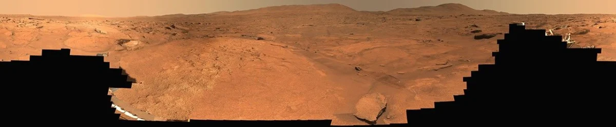
NASA’s Perseverance Mars rover has successfully captured a breathtaking 360-degree panoramic view of a geologically significant region on the Red Planet, informally dubbed "Turquoise Bay." This area, located within the broader "Margin Unit" of Jezero Crater, represents a critical focal point for the rover’s scientific investigations into Mars’ ancient past and its potential to have harbored microbial life. The expansive panorama, meticulously stitched together from 818 individual images taken by the rover’s advanced Mastcam-Z imager, was captured over a period of eleven Martian days, or sols, between October 5 and October 16, 2023, corresponding to sols 933 through 944 of the mission. The resulting imagery offers scientists an unprecedented, high-resolution glimpse into the sedimentary layers and geological formations that characterize this intriguing Martian landscape, providing crucial data for understanding the planet’s hydrological history and guiding the selection of rock and regolith samples for eventual return to Earth.
The Perseverance Mission: Unveiling Mars’ Ancient Secrets
The Perseverance rover, a cornerstone of NASA’s Mars Exploration Program, embarked on its ambitious journey to the Red Planet on July 30, 2020, from Cape Canaveral Space Force Station in Florida. After a seven-month voyage spanning 292.5 million miles (470 million kilometers), the sophisticated robotic geologist executed a flawless landing on February 18, 2021, within Jezero Crater. This particular landing site was chosen with immense deliberation due to its compelling geological features, notably a well-preserved ancient river delta that once fed into a lake approximately 3.8 billion years ago. Scientists hypothesize that such an environment would have provided ideal conditions for the emergence and sustenance of microbial life, making Jezero Crater a prime location for astrobiological research.
Perseverance’s primary scientific objectives are multi-faceted, encompassing the search for signs of ancient microbial life, characterizing the planet’s geology and past climate, and collecting carefully selected rock and regolith (broken rock and dust) samples. These samples are hermetically sealed in tubes and cached on the Martian surface, forming a critical component of the Mars Sample Return campaign, an ambitious multi-mission endeavor designed to bring these precious materials to Earth for in-depth laboratory analysis. Beyond its astrobiological pursuits, the rover is also paving the way for future human exploration of Mars by testing technologies such as MOXIE (Mars Oxygen In-Situ Resource Utilization Experiment), which successfully demonstrated the ability to produce oxygen from the Martian atmosphere.
Exploring the "Margin Unit" and "Turquoise Bay"
The rover’s current area of operation, the "Margin Unit," is of significant scientific interest. Jezero Crater itself is approximately 45 kilometers (28 miles) in diameter, and its floor is rich with diverse geological formations. The "Margin Unit" is believed to represent a specific geological boundary or layer within the crater, possibly marking the ancient shoreline of the lake or a distinct period of geological activity. Understanding the stratigraphy and composition of this unit is crucial for reconstructing the environmental conditions that prevailed in Jezero billions of years ago.
"Turquoise Bay," the specific site where the panorama was captured, is an informal designation given by the science team to a particular feature within the "Margin Unit." Such informal names are commonly used by mission teams to facilitate communication and navigation across the Martian landscape, often reflecting distinctive visual characteristics or geological hypotheses. While the panorama is presented in natural color, an enhanced-color version (Figure A) was also processed. This enhanced view, achieved by accentuating subtle color differences, is particularly valuable for highlighting variations in mineral composition and geological textures that might not be immediately apparent to the human eye. The name "Turquoise Bay" itself suggests that this particular area may exhibit unique coloration, perhaps indicating the presence of specific hydrated minerals or altered rock types that warrant closer inspection. Sedimentary rocks, especially those formed in ancient lake environments, are considered prime targets in the search for biosignatures, as they can effectively preserve evidence of past life. The layered structures visible in the panorama are indicative of depositional processes, potentially revealing long-term environmental changes within the ancient lake system.
The Precision of Mastcam-Z: A Scientific Eye on Mars
The 360-degree panorama of "Turquoise Bay" was acquired using Perseverance’s Mastcam-Z instrument, a pair of high-resolution, zoomable cameras mounted on the rover’s mast. This advanced imaging system is critical to the mission’s scientific success, offering a host of capabilities that far exceed previous Martian camera systems. Mastcam-Z provides stereoscopic (3D) vision, allowing scientists to perceive depth and terrain features with greater accuracy, which is vital for geological interpretation and rover navigation. Its zoom capability enables detailed examination of distant geological targets without requiring the rover to drive closer, conserving precious mission time and resources.
Furthermore, Mastcam-Z is a multi-spectral imager, meaning it can capture images across various wavelengths of light, including those beyond the visible spectrum. This multi-spectral data is invaluable for identifying and characterizing different minerals, as various minerals absorb and reflect light differently depending on their chemical composition. By analyzing these spectral "fingerprints," scientists can infer the mineralogy of rocks and soils, providing clues about their formation history and exposure to water. The ability to capture 818 individual images and stitch them into a seamless, high-resolution panorama demonstrates the instrument’s operational flexibility and the meticulous planning of the science team. These panoramas are not merely aesthetically pleasing; they serve as comprehensive visual records of the rover’s surroundings, informing decisions about where to drive, what rocks to investigate with other instruments, and which samples to collect.
The development and operation of the Mastcam-Z instrument represent a significant international collaboration. While NASA’s Jet Propulsion Laboratory (JPL), managed by Caltech in Pasadena, California, built and manages the overall operations of the Perseverance rover, Arizona State University (ASU) leads the operations of the Mastcam-Z instrument. ASU works in close collaboration with Malin Space Science Systems (MSSS) in San Diego, which was instrumental in the design, fabrication, testing, and operation of the cameras. Further collaboration extended to the Niels Bohr Institute of the University of Copenhagen, which contributed to the design, fabrication, and testing of the calibration targets used to ensure the accuracy of the camera’s color and spectral measurements. This multi-institutional effort underscores the global nature of space exploration and the shared scientific pursuit of understanding Mars.
A Glimpse into Rover Operations: Sols 933-944
The period between October 5 and October 16, 2023, encompassing sols 933 to 944, was a busy and productive stretch for the Perseverance rover. During these eleven Martian days, the rover was strategically positioned within "Turquoise Bay" to capture the comprehensive set of images required for the panorama. Rover operations on Mars are a complex ballet of planning, execution, and data transmission, meticulously orchestrated by teams on Earth. Each sol typically involves a cycle of activities: waking up, communicating with Earth via the Deep Space Network, receiving new instructions, executing scientific observations (like capturing panoramic images), potentially driving, and then settling down for the Martian night to recharge its batteries.
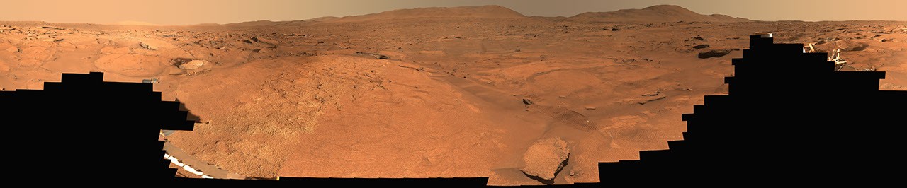
The decision to capture such an extensive panorama over multiple sols indicates the scientific team’s high interest in the geological features of "Turquoise Bay." By taking images over several days, the team can account for varying lighting conditions throughout the Martian day, which can subtly alter the appearance of geological features and provide different perspectives on textures and shadows. The 818 images collected during this period were then transmitted back to Earth, a process that relies on a network of deep space antennas and often utilizes Mars orbiters (like the Mars Reconnaissance Orbiter or MAVEN) as relay stations to maximize data transfer rates. Once on Earth, these images undergo initial processing for calibration and then are meticulously stitched together by imaging specialists to create the final panoramic product, available in both natural and enhanced-color versions for scientific analysis.
Scientific Analysis and Implications for Sample Return
The panoramic images from "Turquoise Bay" are not merely stunning visuals; they are a rich dataset for geological and astrobiological analysis. Scientists will scrutinize every detail, looking for clues about the region’s formation, the types of minerals present, and any features that might indicate past habitable environments. The enhanced-color version, in particular, will aid in differentiating between various rock types and detecting subtle mineralogical variations that could point to the presence of hydrated minerals, often indicators of past water interaction.
Observations such as the layering within the sedimentary rocks can reveal information about depositional environments—whether the sediments were laid down slowly in a calm lake, or rapidly by flowing water, for instance. Erosion patterns, jointing, and fracturing of the rocks can also provide insights into the geological history of the area, including tectonic activity or exposure to wind and water erosion over billions of years. All these details contribute to building a comprehensive geological map of Jezero Crater, a critical step in understanding the broader context of Mars’ evolution.
Crucially, these detailed panoramas play a vital role in the Mars Sample Return campaign. The images help the science team identify promising rock and regolith targets that exhibit characteristics indicative of ancient habitable environments or the potential to preserve biosignatures. Once a target is selected, Perseverance can then deploy its suite of contact instruments, such as the Planetary Instrument for X-ray Lithochemistry (PIXL) and the Scanning Habitable Environments with Raman & Luminescence for Organics and Chemicals (SHERLOC), for closer inspection before the final decision is made to drill a core sample. Each sample collected is a piece of the Martian puzzle, carefully chosen to represent the diverse geological and environmental history of Jezero Crater.
Mars Sample Return: A Collaborative Endeavor
The Mars Sample Return campaign is arguably the most ambitious robotic space mission ever conceived, involving a multi-national collaboration between NASA and the European Space Agency (ESA). Perseverance is the crucial first step, collecting and caching samples on the Martian surface. The subsequent phases involve a Sample Retrieval Lander, which will carry a Mars Ascent Vehicle (MAV) and two Ingenuity-class helicopters to Jezero Crater. The helicopters will retrieve the cached sample tubes and transport them to the MAV. The MAV will then launch the samples into Mars orbit, where an Earth Return Orbiter (ERO) provided by ESA will capture them. Finally, the ERO will bring the samples back to Earth, likely in the early 2030s.
The scientific payoff of bringing Martian samples to terrestrial laboratories is immense. Earth-based labs possess analytical capabilities far exceeding what can be deployed on a rover. High-precision instruments can analyze the samples at a molecular level, allowing for definitive identification of organic molecules, isotopic ratios, and microfossils that could unequivocally prove the existence of past life on Mars. Furthermore, these samples will provide invaluable ground truth for calibrating remote sensing data from orbiters and understanding the processes that have shaped Mars over geological timescales. The insights gained will not only transform our understanding of Mars but also offer broader perspectives on planetary habitability and the potential for life beyond Earth.
Broader Implications for Human Exploration and Planetary Science
The ongoing success of the Perseverance mission, exemplified by achievements like the "Turquoise Bay" panorama, extends far beyond astrobiology. The detailed geological mapping and characterization of Jezero Crater contribute significantly to our understanding of planetary evolution. By studying Mars’ past, particularly its transition from a potentially habitable, water-rich world to the cold, arid planet we observe today, scientists can gain critical insights into the processes that shape planetary environments, including Earth’s own long-term climate evolution.
Moreover, Perseverance’s work is directly informing future human missions to Mars. The rover’s robust performance, its ability to navigate complex terrain, and its data collection capabilities are invaluable for designing more capable human-rated systems. Technologies like MOXIE, which has now repeatedly demonstrated oxygen production, are directly addressing critical challenges for human exploration, such as in-situ resource utilization (ISRU) to reduce the mass and cost of missions. The detailed imagery and geological context provided by panoramas like "Turquoise Bay" will also be vital for future human explorers, helping them understand their surroundings, identify potential hazards, and locate resources.
The awe-inspiring images sent back by Perseverance, including this latest panorama, also serve a crucial role in public engagement and inspiration. They allow humanity to virtually stand on the surface of another planet, fostering a sense of wonder and encouraging the next generation of scientists, engineers, and explorers. The collaborative efforts of numerous institutions and thousands of dedicated individuals underscore humanity’s shared ambition to push the boundaries of knowledge and explore the cosmos. As Perseverance continues its extended mission, each new image and every collected sample brings us closer to unraveling the profound mysteries of Mars and our place in the universe.