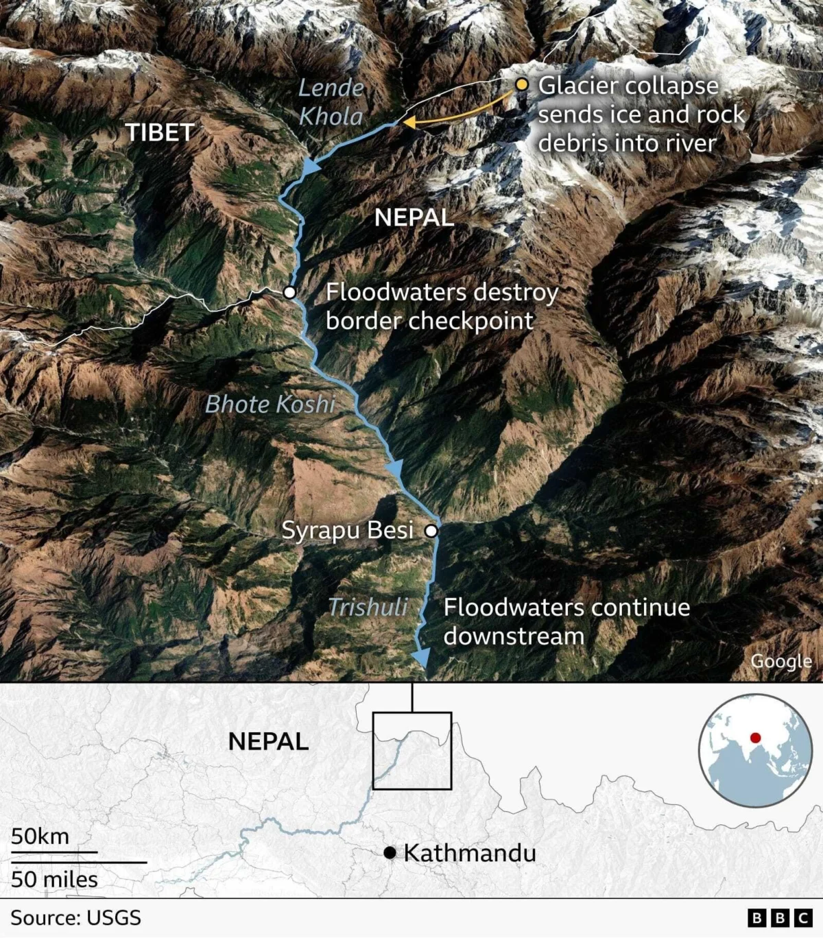
A devastating series of flash floods and massive landslides has ravaged the highly sensitive Nepal-Tibet border region, resulting in widespread destruction and leaving hundreds confirmed dead or unaccounted for. The calamity, which struck on Wednesday, has initiated extensive search and rescue operations across the rugged Himalayan terrain as authorities from both Nepal and China grapple with the immense scale of the disaster and the harrowing task of locating survivors and victims. Chinese state media has reported significant casualties, while Nepalese officials have characterized the situation as "huge scale loss," underscoring the severity of the crisis unfolding in one of the world’s most geographically challenging areas. Compounding the immediate tragedy is the looming threat of further inundation, as reports indicate the formation of a growing lake of water along the China-Nepal border, raising urgent fears of a potential breach that could unleash secondary, equally destructive floods downstream.
Unraveling the Disaster: A Chronology of Events
The catastrophic events of Wednesday began with initial reports suggesting an earthquake near the Nepal-Tibet border. This seismic activity was widely believed to have triggered the landslides and subsequent floods that unleashed a torrent of destruction. However, the United States Geological Survey (USGS) later provided crucial clarification, identifying the true genesis of the disaster not as a traditional tectonic earthquake, but as a "glacial collapse." This phenomenon, where a significant portion of a glacier disintegrates and detaches, created an impact so immense that it registered a magnitude of 5.2 on seismic instruments, effectively mimicking an earthquake. The sheer force of the collapsing ice and rock as it impacted the valley floor sent shockwaves through the region.
This initial glacial collapse then set off a chain reaction. The immense volume of ice and rock debris cascaded into river systems, most notably the Lende Khola, Bhote Koshi, and Trishuli rivers, transforming them into raging torrents of mud, water, and rubble. This "debris flow," as described by the USGS, caused "subsequent catastrophic impacts downstream." The fast-moving wave of material inundated northern Nepalese towns and villages, including areas frequented by mountaineering tourists and pilgrims, and swept across the border into Tibet. The immediate aftermath saw extensive damage to infrastructure, with buildings, roads, and vehicles being engulfed and swept away, particularly in Nepal’s Nuwakot region. The disaster unfolded with terrifying speed, leaving little time for residents to react or evacuate, plunging the region into a state of emergency and triggering an urgent, multinational response.
The Science Behind the Cataclysm: Glacial Collapse and Climate Change
The revelation that a glacial collapse, rather than a conventional earthquake, was the primary trigger for the disaster has placed a renewed focus on the delicate ecological balance of the Hindu Kush Himalaya (HKH) region and the profound impact of climate change. A glacial collapse occurs when a glacier or a substantial part of it becomes unstable and detaches, often due to warming temperatures that weaken the ice and surrounding permafrost. The sheer kinetic energy released when such a massive body of ice and rock plunges into a valley is immense, explaining why the event registered as a magnitude 5.2 seismic tremor, an unusual but not unprecedented occurrence for such phenomena.
Experts in glaciology and Earth sciences are actively analyzing satellite imagery and other data to reconstruct the precise sequence of events. Simon Cook, a senior lecturer in energy, environment, and security at the University of Dundee specializing in glaciology, indicated that his team detected a collapse in the lower part of a glacier near Nepal’s Langtang Lirung peak, approximately 15 kilometers west of the main flood site. He estimated the glacier collapsed in a north-westerly direction before moving westwards downstream. Cook highlighted a critical factor: "permafrost is partially holding some mountainsides together, this permafrost is warming and thawing and degrading so you are going to get more landslides." This degradation of permafrost, the permanently frozen ground that acts as a natural cement for mountain slopes, significantly increases the instability of the terrain, making it more susceptible to landslides and rockfalls when combined with glacial melt or heavy rainfall.
Professor Mike Searle of Oxford University’s Earth sciences department suggested that the glacial collapse might have occurred "hours or days" before the full force of the flooding hit downstream communities. He posited a scenario where "the sheer wave of debris suggests there was a landslide first, the water built up, (which) dammed the river, and then it burst in one huge great flood." This mechanism—a natural damming of a river by landslide debris, followed by a sudden, catastrophic breach—is a known hazard in mountainous regions and can unleash far more destructive floods than typical river overflows. Scientists are examining whether water from intense rainfall or accelerated ice melt might have destabilized the ground or the glacier itself, initiating this destructive chain reaction. Ongoing investigations will meticulously analyze satellite images to pinpoint the exact location of the collapse, monitor any sudden drainage of glacial lakes, identify river blockages, and correlate these findings with recent meteorological data, including rainfall patterns, to fully understand the dynamics of this complex and devastating event. The implications of such an event underscore the heightened vulnerability of the HKH region to climate change-induced geological hazards.
A Region Overwhelmed: Scale of Devastation and Affected Areas
The flash floods and landslides unleashed an unprecedented wave of destruction across the border region, particularly impacting northern Nepalese towns and infrastructure. The deluge of material, comprising mud, rock, and water, careered with immense force towards communities, including areas popular with international mountaineering tourists and religious pilgrims. The border zone itself, situated approximately 64.4 kilometers (40 miles) north of Nepal’s bustling capital city, Kathmandu, is a critical corridor for trade and tourism between Nepal and China.
Eyewitness accounts and harrowing footage captured the sheer power of the disaster. Video recordings depict a towering wall of mud and rock sweeping away buildings, obliterating sections of roads, and engulfing vehicles, forcing residents to flee in terror from the fast-moving wave in Nepal’s Nuwakot region. One particularly striking video showed a colossal wall of water and mud surging down a gorge along the Trishuli River, completely enveloping the multi-story Rasuvagadhi Border checkpoint, a vital facility connecting the two nations.
Severe flooding has been reported extensively along several major river systems that originate in the Himalayas and flow southward, including the Bhote Koshi, Trishuli, and Narayani rivers. These rivers, usually formidable, were transformed into instruments of chaos, carving new paths of destruction and significantly altering the landscape. On the Nepalese side, the impact was felt far downstream, with fatalities reported in communities such as those in the Chitwan district and Nawalparasi East, hundreds of kilometers from the initial collapse site, highlighting the vast reach of the floodwaters.
The devastation was not confined to Nepal. Villages on the Tibetan side of the border also reported deaths and significant damage, underscoring the cross-border nature of the catastrophe. The destruction of critical infrastructure, including roads and bridges, has severely hampered access for relief efforts, isolating many communities and complicating the assessment of the full extent of the damage. The economic repercussions are expected to be substantial, particularly for the tourism sector which is a cornerstone of Nepal’s economy, and for cross-border trade which relies heavily on the now-destroyed routes. The event serves as a stark reminder of the immense power of natural forces in the Himalayas and the profound vulnerability of human settlements within this dynamic environment.
The Human Toll: Search, Rescue, and Mounting Casualties
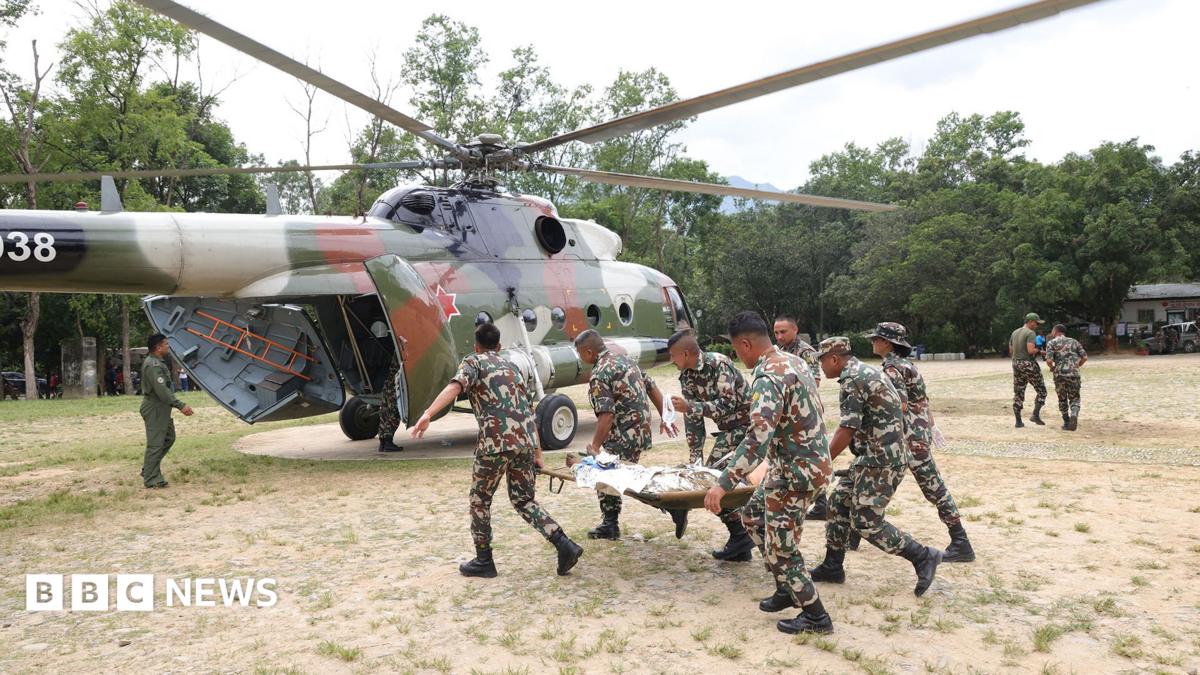
The grim task of determining the full human toll of the flash floods and landslides is an ongoing and complex endeavor, with casualty figures continuing to emerge from both Nepal and China. The sheer scale of the disaster, coupled with the rugged and remote terrain, has made comprehensive assessment and search operations incredibly challenging.
As of the latest updates, Nepali police have reported at least 389 confirmed fatalities. The reach of the floodwaters is evident in the distribution of these casualties, with 64 bodies recovered from downstream areas in the Chitwan district and another 26 found in Nawalparasi East, far from the initial point of impact. Nepal’s National Disaster Risk Reduction and Management Authority provided a sobering update, stating that 910 individuals were still officially missing. This figure includes a significant number of foreign citizens, totaling 517, alongside 44 members of the Nepal Army and 28 Nepal police officers, highlighting the danger faced by those involved in the initial response and those residing in the affected zones.
Across the border, China’s state broadcaster CCTV reported that the number of people missing in the mudslide disaster in Tibet’s Gyirong county had tragically risen to 558. Among these, 260 foreign nationals are believed to be missing, though the reported death toll on the Chinese side remained at three. The Gyirong border crossing is a crucial artery for both tourists and commercial traffic between China and Nepal, explaining the high number of international travelers affected.
The Nepal Tourism Board further elaborated on the missing tourist figures, stating that 644 tourists were still unaccounted for. This group included a notable contingent of 33 UK nationals, among them a 13-year-old girl and a 14-year-old boy, underscoring the tragedy’s impact on families and individuals from around the globe. Smaller numbers of travelers from other nations, including South Korea, South Africa, Portugal, the Netherlands, and New Zealand, are also officially listed among the missing. A critical challenge for international relief efforts is the potential for double-counting among the Nepali and Chinese figures for missing foreign nationals, complicating the precise tally and coordination of search efforts. The international community watches with bated breath as search and rescue teams, often battling treacherous conditions, continue their relentless efforts to find survivors amidst the debris and mud, offering hope to the families of those still missing.
Lingering Threats: The Specter of Secondary Flooding
Even as immediate search and rescue operations intensify, the region faces a grave and persistent danger: the threat of secondary flooding. The International Centre for Integrated Mountain Development (ICIMOD) has issued urgent warnings regarding this potential, emphasizing that the massive influx of debris washed into the river systems could lead to further catastrophic events in the coming days.
The primary concern revolves around the formation of "landslide dams." As the colossal volume of mud, rocks, and glacial debris careered downstream, it has likely accumulated in narrower sections of the rivers, particularly the Trishuli River. These accumulations can effectively block the natural flow of the river, creating temporary, unstable dams that cause water to back up and form lakes. If such a landslide dam were to form and subsequently breach, it would unleash a devastating surge of water and debris, akin to the initial flash flood, but potentially with even greater force due to the accumulated pressure.
ICIMOD, a leading institution focused on the sustainable development of the Hindu Kush Himalaya, has initiated rapid assessments to determine whether the Trishuli River or other affected waterways have indeed been temporarily blocked. Their teams are meticulously evaluating the size, location, and stability of any potential blockages using a combination of satellite imagery, aerial surveys, and on-ground reconnaissance. The stability of these natural dams is precarious; they can give way suddenly due to continued water pressure, further landslides, or even seismic tremors.
Authorities in both Nepal and China are closely monitoring the situation, recognizing that a second flooding event could compound the already immense damage and loss of life, potentially overwhelming already strained rescue and relief infrastructure. Early warning systems are crucial in such scenarios, but the dynamic and unpredictable nature of landslide dams makes forecasting their exact timing and impact incredibly difficult. The looming threat serves as a stark reminder that the disaster is far from over, and vigilance remains paramount as the region braces for potential further calamities.
Global Solidarity: International Response and Aid Efforts
The monumental scale of the disaster on the Nepal-Tibet border has elicited a rapid and robust international response, with governments and humanitarian organizations around the globe pledging support and aid to the affected nations. The urgent need for assistance, both immediate and long-term, has galvanized a coordinated effort to address the unfolding crisis.
Nepal’s Prime Minister Balendra Shah articulated the profound impact on his nation, stating that "the entire nation has been left shocked and deeply distressed." He assured the public that Nepalese officials would coordinate closely with China on all aspects of the response, recognizing the transboundary nature of the calamity. The emphasis is on collaborative efforts to maximize efficiency in search, rescue, and relief operations.

From China, President Xi Jinping urged "all-out" search efforts to locate the missing and provide care for the affected. Crucially, President Xi also emphasized the need for stronger monitoring and early warning systems to prevent secondary impacts, acknowledging the ongoing threat of further geological events. This focus on prevention and preparedness highlights a proactive approach to mitigating future risks in the vulnerable region.
Neighboring India, a key regional partner, quickly extended its solidarity. Prime Minister Narendra Modi affirmed his government’s readiness "to provide Nepal with all possible types of humanitarian assistance," underscoring the close ties and shared challenges between the two nations. This commitment from India is particularly significant given its geographical proximity and established logistical capabilities.
Beyond the immediate region, the international community has also mobilized. UN Secretary-General António Guterres expressed his profound sorrow, stating he was "saddened by the severe flooding." He confirmed that UN teams and partners are actively mobilizing essential supplies and personnel within Nepal to bolster the government-led response, focusing on critical areas such as emergency shelter, food, and medical aid. The United States has pledged substantial financial assistance, committing $500,000 (£367,982) to cover immediate needs like emergency shelter, water, sanitation, and other vital relief items for the devastated communities. Similarly, the United Kingdom, through Prime Minister Andy Burnham, announced an offer of £5 million to assist the Nepalese government and affirmed a commitment to do "everything we can" to support British nationals affected by the disaster in Nepal. These pledges of aid, both financial and logistical, are critical for the immediate humanitarian response and will be instrumental in supporting the long and arduous journey towards recovery and rebuilding for the countless individuals and communities impacted by this catastrophic event.
Broader Implications: Vulnerability, Preparedness, and the Future
The catastrophic glacial collapse and subsequent flash floods on the Nepal-Tibet border represent a stark and tragic manifestation of the escalating environmental challenges confronting the Hindu Kush Himalaya region. Beyond the immediate human toll and infrastructural devastation, this event carries profound broader implications for regional stability, long-term development, and the urgent global imperative to address climate change.
The immediate aftermath will see immense challenges in rebuilding lives and livelihoods. The destruction of critical infrastructure, including roads, bridges, and border checkpoints, will severely disrupt trade and connectivity, impacting local economies heavily reliant on cross-border commerce and tourism. The loss of agricultural land and homes will displace countless families, necessitating sustained humanitarian assistance, rehabilitation programs, and psychological support for communities grappling with immense trauma and loss. The economic impact on Nepal, where tourism is a cornerstone, will be particularly severe, affecting thousands of families directly and indirectly.
From an environmental perspective, the disaster underscores the extreme vulnerability of mountainous regions to the impacts of a warming planet. The glacial collapse, strongly linked to climate change-induced glacier melt and permafrost degradation, serves as a grim precursor of potential future events. Scientists warn that as global temperatures continue to rise, the stability of glaciers and mountain slopes in the Himalayas will further diminish, increasing the frequency and intensity of similar disasters. This necessitates a global commitment to reducing greenhouse gas emissions and a localized focus on climate adaptation strategies.
The event also highlights critical deficiencies in disaster preparedness and early warning systems in such remote and geologically active areas. While traditional seismic monitoring is robust, detecting and predicting glacial collapses and subsequent landslide dam formations remains a significant scientific and logistical challenge. There is an urgent need for enhanced investment in advanced monitoring technologies, including satellite surveillance, drone technology, and ground-based sensors, coupled with improved communication networks to ensure timely warnings reach vulnerable communities. International collaboration in scientific research and data sharing is paramount to developing more effective predictive models and response protocols.
Ultimately, the tragedy on the Nepal-Tibet border serves as a powerful call to action. It demands not only immediate humanitarian aid and coordinated rescue efforts but also a concerted, long-term strategy for building resilience in the face of escalating climate-induced hazards. This includes fortifying infrastructure against extreme events, implementing comprehensive land-use planning that considers geological risks, and empowering local communities with knowledge and resources for self-protection. The future of the Himalayan region, and indeed many other vulnerable mountain ecosystems worldwide, hinges on how effectively the global community responds to such devastating warnings from nature.