



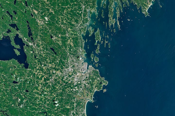
The dramatic demarcation of Maine’s coastline, particularly the stark contrast between the sandy, marsh-laden shores west of Portland and the rugged, rocky promontories to its northeast, has long captivated both scientific inquiry and Indigenous storytelling. This distinctive geological divide, vividly captured in satellite imagery such as the recent Landsat observation featured as the Image of the Day for July 21, 2026, serves as a natural laboratory for understanding the profound interplay of ancient bedrock, immense glacial forces, and the relentless sculpting power of rivers, waves, and tides. The visible differences are not merely aesthetic; they underpin the very economic and ecological character of Maine’s diverse coastal communities, influencing everything from tourism and traditional fisheries to nascent aquaculture industries.
Unearthing Ancient Origins: The Bedrock Foundation
At the heart of Maine’s coastal variations lies its complex geological history, stretching back hundreds of millions of years. The state sits at the convergence of ancient continental collisions, a tumultuous past that has left a legacy of diverse rock formations. West and south of Portland, the underlying geology tends towards a mix of less resistant sedimentary rocks and some igneous intrusions, often covered by thicker layers of glacial till and marine sediments. This softer foundation is more susceptible to erosion and, crucially, provides a base for the accumulation of sand and silt. This region’s bedrock is often younger and less intensely metamorphosed than its eastern counterpart, allowing for the subsequent deposition of unconsolidated glacial and fluvial materials.
Conversely, the Midcoast region and areas further northeast, including Downeast Maine and Acadia National Park, are dominated by far older and more resistant metamorphic and igneous rocks. These include granites, schists, and gneisses, which were subjected to immense pressures and temperatures deep within the Earth’s crust during ancient mountain-building events, such as the Appalachian Orogeny. This period, spanning from roughly 480 to 250 million years ago, involved continental plates colliding, thrusting up mountain ranges, and transforming existing rock layers. These rocks are characterized by their "tortured folds," as Nicholas Whiteman, a geologist with the Maine Geological Survey, describes, indicating layers of rock that have been contorted and compressed over geological timescales. This inherent strength and structural complexity of the bedrock dictate the rugged, resilient nature of the eastern coastline, where rock rather than sediment defines the interface between land and sea.
The Sculpting Hand of Ice: Maine’s Glacial Legacy
The most recent and perhaps most profound shaper of Maine’s modern coastlines was the Last Glacial Maximum (LGM), a period approximately 20,000 years ago when the vast Laurentide Ice Sheet covered much of North America, including all of Maine. This colossal sheet of ice, at times over a mile thick, acted as an immense geological bulldozer, profoundly altering the landscape. The sheer weight and erosive power of the ice transformed pre-existing river valleys and hills into the features observed today.
As the Laurentide Ice Sheet slowly advanced and retreated between roughly 26,000 and 10,000 years ago, it scoured away vast quantities of loose soil and bedrock. In the hard rock regions of Midcoast and Downeast Maine, glaciers carved deep U-shaped valleys, widened existing fractures in the metamorphic rock, and plucked away less resistant sections, leaving behind dramatic cliffs, exposed ledges, and elongated ridges. The weight of the ice sheet also depressed the land, a phenomenon known as glacial isostasy, pushing the Earth’s crust downwards by hundreds of feet.
When the climate warmed and the glaciers began their final retreat approximately 18,000 to 10,000 years ago, several critical processes unfolded. Massive volumes of meltwater carried enormous quantities of sediment – sand, gravel, and clay – southward. In southern Maine, where the underlying bedrock was less resistant and the topography generally flatter, these sediments were deposited in broad, thick layers. Rivers emerging from the retreating ice front became conduits for this material, distributing it across the landscape and into nascent coastal environments. The rate of sediment delivery was immense, creating vast outwash plains.
Crucially, as the ice sheet melted, global sea levels rose dramatically, a process known as eustatic sea-level rise, by an estimated 120 meters globally. Simultaneously, the land, freed from the immense weight of the ice, began to slowly rebound, a process that continues today at rates of a few millimeters per year in some areas. The complex interplay between this land uplift and sea-level rise determined how the newly exposed and sediment-laden landscapes interacted with the encroaching ocean. In the Midcoast, the rise in sea level flooded the glacially carved valleys, creating the characteristic drowned river valleys, or "rias," that form the region’s intricate network of long, narrow peninsulas and islands, such as those found within Casco Bay.
The Southern Maine Coast: A Symphony of Sand and Marsh
The coastal stretch west of Portland, emblematic of southern Maine, presents a striking contrast to its eastern counterpart. Here, the landscape is defined by expansive sandy beaches, dynamic dune systems, and vast salt marshes. This character is largely attributed to the abundant sediment supply and the geological framework that allowed for its accumulation and reworking.
As Peter Slovinsky, a geologist with the Maine Geological Survey, explains, much of the sand in southern Maine originated from the weathering and breakdown of the White Mountains, located inland to the west. During and after the glacial period, powerful rivers like the Saco River acted as conveyor belts, transporting this sediment to the coast. The Saco River, for instance, has played a pivotal role in shaping Saco Bay, which boasts Maine’s longest contiguous beach, extending for nearly 15 miles, and the state’s largest saltmarsh, the Scarborough Marsh, encompassing over 3,000 acres.

Once delivered to the coast, these soft sediments were, and continue to be, meticulously reworked by waves, tides, and currents. Over millennia, these forces sculpted the deposits into the distinctive arch-shaped embayed beaches, where crescentic stretches of sand are cradled between rocky headlands, and the sprawling salt marshes that are vital ecological hubs. These marshes, such as the Scarborough Marsh, are among the most productive ecosystems on Earth, filtering water, providing critical habitat for migratory birds and marine life, and acting as natural buffers against storm surges and coastal erosion. They are also significant carbon sinks, sequestering atmospheric carbon dioxide at rates estimated between 100 to 200 grams of carbon per square meter per year, comparable to tropical rainforests. The dynamic nature of these sandy and marshy environments, while appealing for recreation, also renders them particularly vulnerable to the impacts of sea-level rise and increased storm intensity, making adaptive management crucial.
The Midcoast and Downeast: A Realm of Rock and Rias
Moving eastward from Portland, the coastline transforms dramatically into the "Midcoast" region, a realm dominated by the rugged resilience of metamorphic bedrock. This transition marks a fundamental shift in geological character. Instead of broad sand deposits, one encounters whole ridges and valleys composed of rock layers that have been intensely folded and faulted over geological time.
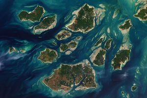
Around Casco Bay, these ancient ridge-and-valley systems, coupled with the "drowning" of the shoreline as sea levels rose post-glaciation, have produced the region’s signature jagged, highly indented coastline and its multitude of long, narrow islands. The "tortured folds" of these bedrock formations create inherent directional weaknesses that erosion readily exploits, leading to the distinctive orientation of islands and peninsulas that fascinates geologists like Nicholas Whiteman. The prevailing strike of these folds often dictates the alignment of the numerous peninsulas and islands, creating a distinctive pattern that is visually evident from satellite perspectives. This intricate labyrinth of land and sea extends further northeast into Downeast Maine and Acadia National Park, where the glacial scouring of granite and metamorphic rock has created breathtaking fjard-like inlets, towering cliffs, and exposed intertidal zones. The sheer scale of the rock formations, often rising directly from the ocean, tells a story of immense geological power and enduring resistance to the elements, attracting millions of visitors annually to Acadia National Park alone.
Wabanaki Narratives: Cultural Echoes of Geological Forces
Long before modern geological science began to unravel the origins of Maine’s coastlines, the Wabanaki people—comprising the Penobscot, Passamaquoddy, Maliseet, Micmac, and Abenaki nations—held a deep well of creation myths that explained their world. Their stories often reflect a profound understanding of natural phenomena, passed down through generations and embodying thousands of years of observation and interaction with the land and sea.
Many of these myths, particularly those pertaining to the dramatically rocky coasts of the Bay of Fundy, Downeast Maine, and Acadia National Park, center around Glooscap (or Gluskabe), a magical culture hero and transformer figure. Glooscap is said to have floated down the Bay of Fundy in a stone canoe, his powerful vessel scraping across the landscape, thereby sculpting coastal features like mountains, rivers, and islands. Battles with primordial, gigantic animals—beavers, frogs, moose, and whales—are recounted as scattering enormous boulders across the land, explaining the erratics and rocky shorelines that dot the region. These narratives are more than mere folklore; they are sophisticated interpretations of geological processes, offering cultural frameworks for understanding a dynamic environment. The myths embody the Wabanaki’s ancestral knowledge of their territory, reflecting observations of erosion, glacial deposits, and the relentless power of the sea, intertwined with spiritual significance and a deep connection to the land and its creatures. The rich oral tradition ensured that these explanations of the landscape were integral to Wabanaki identity and education.
The article notes fewer Indigenous creation myths survive to explain the origins of the sandy and marshy shorelines of southern Maine and the Midcoast region. While this could be due to various factors, including the devastating impact of colonization, disease, and forced assimilation on cultural transmission, it might also reflect the Wabanaki’s more concentrated historical presence and subsistence activities in the areas defined by the rugged, resource-rich eastern coastlines. The dramatic geological features of the eastern coast, with their stark cliffs, deep inlets, and abundant resources, would naturally inspire more elaborate origin stories and serve as central points in their cultural geography.
Economic Engines: How Geology Shapes Livelihoods
The contrasting geological profiles of Maine’s coastlines have profound implications for the state’s economy and the livelihoods of its coastal communities. The natural features dictate the types of industries that thrive, illustrating a direct link between geomorphology and human activity.
Tourism and Recreation in Southern Maine: The expansive, sandy beaches of southern Maine, sculpted by riverine sediment and wave action, are a major draw for tourists. Communities like Saco, Kennebunkport, and Old Orchard Beach thrive on beach-related tourism, attracting an estimated 38 million visitors to Maine annually, with a significant portion drawn to its southern shores. This sector contributes billions of dollars to the state’s economy through hospitality, retail, and local services, supporting thousands of jobs. The vulnerability of these beaches to erosion and rising sea levels necessitates careful coastal management strategies, including strategic beach nourishment projects, robust dune restoration programs, and the implementation of setback regulations, to preserve these vital economic assets for future generations.
Lobster and Fisheries in Midcoast Maine: In stark contrast, the rocky, indented coastline of Midcoast Maine provides the ideal habitat for the state’s iconic lobster fisheries. The numerous protected coves, inlets, and rocky ledges offer shelter and nutrient-rich cold waters where American lobsters (Homarus americanus) thrive. The complex underwater topography, characterized by rocky bottoms and crevices, provides abundant hiding places and foraging grounds for the crustaceans. Maine consistently leads the nation in lobster landings, with the industry valued at over $500 million annually. Towns like Harpswell, Friendship, and Vinalhaven consistently rank among the leaders in lobster landings, forming the backbone of Maine’s maritime economy. This industry, deeply rooted in tradition, faces contemporary challenges from changing ocean temperatures, acidification, and international market dynamics, making sustainable management, data-driven conservation efforts, and adaptation to climate-induced shifts in lobster populations critical for its long-term viability.
The Rise of Aquaculture and "Merroir": The sheltered waters of Midcoast Maine, particularly within Casco Bay and the Damariscotta Estuary, have also become fertile grounds for a burgeoning aquaculture industry, most notably oyster farming. These protected bays offer a unique combination of conditions—varied temperatures, salinities, and nutrient levels—that create distinct "microclimates." As Tom Kiffney, a researcher at the University of Maine, explains, these environmental nuances contribute to what is known as "merroir," a term akin to "terroir" in wine, describing how local environmental conditions impart unique flavors and characteristics to the oysters. This diversity allows Maine oyster farmers to cultivate a wide array of premium oysters, catering to discerning markets