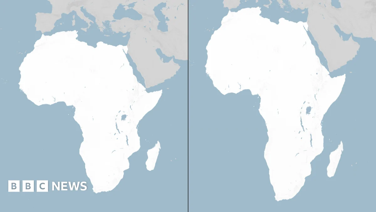
The African Union (AU) has taken a significant step towards decolonizing cartography by formally adopting the Equal Earth projection, a decision poised to fundamentally alter how the world perceives its geographical realities, particularly the true scale of the African continent. This landmark move, endorsed by the AU’s 54 member states in February, represents a concerted effort to correct the pervasive distortions inherent in the widely used Mercator map, which has dominated global navigation and education for nearly five centuries. The subsequent non-binding vote at the United Nations is expected to catalyse a broader shift in mapping practices across international institutions and educational systems worldwide, initiating a crucial dialogue about the power of maps to shape perceptions and influence geopolitical understanding.
The Enduring Legacy and Inherent Flaws of the Mercator Projection
For centuries, the world has largely navigated and conceptualized its geography through the lens of the Mercator projection, a map designed in 1569 by the Flemish cartographer Gerardus Mercator. His primary objective was to assist European explorers in charting their courses across vast oceans, particularly during the Age of Discovery. The Mercator map achieved this by projecting the spherical surface of the Earth onto a flat, two-dimensional chart using a method that maintained accurate compass bearings, making it invaluable for maritime navigation. Lines of longitude appear parallel, and lines of latitude are equally spaced, allowing sailors to draw a straight line between two points and maintain a constant bearing, a feature known as a rhumb line.
However, this navigational utility came at a considerable cost: extreme distortion of landmass sizes, especially at higher latitudes. The fundamental challenge in cartography is the impossibility of accurately representing a three-dimensional sphere on a two-dimensional plane without introducing some form of compromise. Mercator chose to preserve angles and shapes locally, but sacrificed the accuracy of area. This decision resulted in countries nearer the equator appearing significantly smaller than their actual size, while those closer to the poles, such as Greenland, Russia, and Canada, were dramatically exaggerated. For instance, on a Mercator map, Greenland often appears comparable in size to Africa, despite being approximately 14 times smaller in actual land area. Russia and Canada also appear disproportionately vast, contributing to a perception of immense scale that does not align with their true geographical footprint relative to equatorial regions.
This distortion was not merely a technicality; it embedded a subtle yet powerful Eurocentric bias into global consciousness. By visually diminishing the size of continents like Africa and South America while aggrandizing Europe and North America, the Mercator projection inadvertently reinforced colonial narratives and perceptions of power dynamics. It subtly suggested a hierarchy of importance based on perceived land area, which often correlated with colonial ambitions and the geopolitical influence of the time. The map, therefore, transcended its initial navigational purpose to become a powerful cultural artifact, shaping educational curricula, news reporting, and public understanding of the world for generations.
The Quest for Cartographic Equity: A History of Alternatives
The critiques of the Mercator projection are not new. For decades, cartographers, educators, and social scientists have debated the ethical and perceptual implications of its widespread use. The inherent compromises required in any world map mean that different projections prioritize different attributes: some preserve area (equal-area projections), others preserve shapes locally (conformal projections), and still others attempt a balance (compromise projections). The Mercator map is a conformal projection.
One of the most notable early challenges to Mercator was the Gall-Peters projection, which gained prominence in the 1970s. Developed by James Gall in 1855 and later popularized by Arno Peters in 1973, this projection is an equal-area map, meaning it accurately represents the relative sizes of all landmasses. On a Gall-Peters map, Africa appears vastly larger than Greenland, reflecting reality. However, the Gall-Peters projection achieves this by significantly distorting shapes, particularly elongating landmasses near the equator and compressing them near the poles, leading to a somewhat stretched or squashed appearance that some find aesthetically unpleasing. Despite its accuracy in area, its visual distortions limited its widespread adoption in mainstream contexts, often relegating it to niche educational or advocacy roles.
Other projections, such as the Robinson projection (developed by Arthur H. Robinson in 1961), sought to offer a compromise. The Robinson map does not preserve area, angle, or distance perfectly, but instead attempts to strike a balance between these distortions, aiming for a more visually appealing representation of the entire world. It became widely adopted in textbooks and atlases, including by National Geographic, as a more palatable alternative to Mercator, though it still does not fully address the area distortion issue.
The ongoing search for a map that could accurately represent area while also minimizing shape distortion and maintaining a visually appealing aesthetic continued, driven by a growing global awareness of geographical equity.
The Emergence of the Equal Earth Projection
It was against this backdrop of historical debate and cartographic innovation that the Equal Earth projection was unveiled in 2018. Developed by a team of cartographers including Bojan Savric, Tom Patterson, and Bernhard Jenny, the Equal Earth projection represents a significant advancement in the quest for a more balanced and accurate world map. Its primary distinguishing feature is its commitment to being an equal-area map, meaning that every country and continent is depicted in its true relative size. Crucially, the creators also focused on minimizing the shape distortions that plagued earlier equal-area projections like Gall-Peters, particularly for landmasses near the poles and the equator.
The Equal Earth projection is a pseudo-cylindrical projection, characterized by straight and parallel parallels of latitude, and meridians that are curved. Its design employs polynomial equations to achieve a visually appealing aesthetic that is less jarring than some other equal-area maps while maintaining accuracy of area. On an Equal Earth map, the true scale of continents like Africa and South America becomes immediately apparent, challenging the ingrained mental images fostered by the Mercator projection. For example, Africa, which covers approximately 30.3 million square kilometers, is visibly larger than North America (24.7 million sq km), South America (17.8 million sq km), and certainly dwarfing Europe (10.2 million sq km) and Australia (8.5 million sq km). The visual impact of seeing Africa in its correct proportion – larger than China, India, the contiguous United States, and much of Europe combined – is profound.
The design team meticulously balanced the mathematical requirements for equal area with the aesthetic considerations for legibility and visual appeal, making it a strong contender for widespread adoption in educational, journalistic, and governmental contexts. Its immediate recognition by the cartographic community highlighted its potential to become a new standard.
Chronology of a Cartographic Revolution
2018: The Equal Earth projection is formally introduced by its creators, Bojan Savric, Tom Patterson, and Bernhard Jenny, as a new world map projection designed to accurately represent the relative sizes of all continents and countries while minimizing shape distortion. It quickly garners attention within cartographic and academic circles.
Late 2022 – Early 2023: Advocacy efforts intensify, particularly within African diplomatic circles, highlighting the importance of cartographic accuracy for representing the continent’s true global standing. Discussions around adopting a more equitable map gain momentum within the African Union.
February 2023: In a landmark decision, the African Union’s 54 member states formally adopt the Equal Earth projection. This decision is celebrated as a crucial step towards decolonizing geographical representation and promoting a more accurate understanding of global landmasses. The AU explicitly states that the projection "more accurately represents the sizes of all continents, particularly Africa."
February 2023 (Pre-UN Vote): Togolese Foreign Minister Robert Dussey emerges as a prominent voice in advocating for the Equal Earth projection on the international stage. Ahead of a crucial vote at the United Nations, he tells the Reuters news agency, "A fair world begins with a fair map." Earlier, at a UN briefing, Dussey had articulated the profound impact of maps, stating, "A map is never neutral. It shapes perceptions, influences how the place of peoples and continents in the world is understood." His statements underscore the philosophical and geopolitical weight attached to this cartographic shift.
Recent Past (Date unspecified but implied by "Ahead of Friday’s vote"): The United Nations holds a non-binding vote on the adoption of the Equal Earth projection. While non-binding, the UN vote carries immense symbolic weight and is expected to encourage widespread changes to the maps used by institutions around the world, including UN agencies, educational bodies, and international organizations. This vote signifies a global recognition of the need for cartographic reform.
Supporting Data: Unpacking Mercator’s Deceptions
To fully grasp the significance of the Equal Earth projection and the AU’s decision, it is vital to quantify the scale of Mercator’s distortions:
- Africa vs. Greenland: On many Mercator maps, Greenland (actual area: approximately 2.16 million sq km) appears roughly the same size as Africa (actual area: approximately 30.3 million sq km). In reality, Africa is nearly 14 times larger than Greenland.
- Africa’s True Magnitude: Africa is larger than the combined landmasses of China (9.6 million sq km), India (3.3 million sq km), the contiguous United States (8.1 million sq km), and much of Europe (Europe excluding Russia is about 7.2 million sq km). Its immense size often surprises those accustomed to Mercator’s portrayal.
- Canada and Russia: Canada (9.98 million sq km) and Russia (17.1 million sq km) are vastly exaggerated on Mercator maps, appearing much larger than their true proportions relative to equatorial nations. While large in absolute terms, their visual dominance on Mercator charts is misleading.
- Alaska vs. Brazil: Alaska (1.7 million sq km) can appear larger than Brazil (8.5 million sq km) on a Mercator map, despite Brazil being almost five times its size.
- Equatorial Compression: Countries closer to the equator, such as the Democratic Republic of Congo (2.34 million sq km) or Indonesia (1.9 million sq km), are significantly compressed, diminishing their visual prominence.
These numerical discrepancies highlight how deeply ingrained Mercator’s misrepresentations have become, subtly influencing global perceptions of population distribution, economic power, and geopolitical relevance.
Official Responses and Anticipated Reactions
The African Union’s adoption of the Equal Earth projection is a powerful declaration of self-representation. Statements from AU leaders, such as Minister Dussey’s assertion that "A map is never neutral," reflect a broader sentiment across the continent to challenge historical narratives and establish a more accurate and equitable global presence. This move is expected to resonate deeply within African educational systems, leading to a systematic replacement of Mercator maps with the Equal Earth projection in textbooks, classrooms, and official documents.
Internationally, the UN’s non-binding vote, though not a mandate, serves as a significant endorsement. It is likely to spur discussions and encourage similar adoptions by other international organizations, non-governmental bodies, and academic institutions. Cartographic societies globally are expected to analyze and potentially endorse the Equal Earth projection as a preferred standard for general-purpose world maps. Educational publishers, particularly those focused on geography and social studies, will face increasing pressure to update their materials to reflect this shift, potentially initiating a global re-education campaign on geographical realities. While some institutions may resist due to inertia or cost, the momentum generated by the AU and UN is likely to be substantial.
Broader Impact and Implications
The adoption of the Equal Earth projection carries profound implications across multiple domains:
Educational Reform and Global Awareness
The most immediate and widespread impact will be on education. As the Equal Earth projection replaces Mercator in classrooms, textbooks, and online resources, generations of students will grow up with a more accurate visual understanding of the world. This will foster a more nuanced appreciation for the true scale of continents, particularly those in the Global South, and challenge pre-conceived notions about their relative importance. It will likely spark curiosity and critical thinking about how maps are made and the biases they can carry.
Geopolitical Repercussions and Shifting Perspectives
The visual re-centering of Africa, South America, and other equatorial regions to their true proportions could have subtle but significant geopolitical effects. By presenting a visually fairer world, the Equal Earth map might contribute to a re-evaluation of global power dynamics, fostering a greater focus on the Global South in policy discussions, trade negotiations, and aid initiatives. It can challenge long-held Eurocentric biases that may have been unconsciously reinforced by the Mercator projection, promoting a more balanced and multilateral approach to international relations. The symbolic act of a continent collectively choosing its representation is a powerful statement of agency.
Cultural and Psychological Impact
Maps are not just tools; they are powerful cultural artifacts that shape our mental models of the world. Seeing Africa depicted in its vast, true scale can profoundly impact how people perceive its diversity, resources, and human population. It can foster a greater sense of pride and self-worth within African nations and a more respectful understanding from external observers. This psychological shift, though difficult to quantify, is a crucial aspect of decolonization and promotes a more inclusive global narrative.
Challenges of Implementation and Resistance
Despite the clear benefits, the transition to the Equal Earth projection will not be without challenges. The sheer volume of existing Mercator maps in use – from wall maps and atlases to digital interfaces and navigational systems – represents a massive logistical and financial hurdle. Replacing these will be a gradual process. There may also be resistance from institutions or individuals accustomed to the Mercator projection, either due to familiarity, perceived aesthetic qualities, or simply inertia. Furthermore, the debate about "the perfect map" will likely continue, as even the Equal Earth projection, while excellent for area, still involves some shape distortion (albeit less severe than Gall-Peters). The inherent compromise in translating a sphere to a plane means no single map can be truly "perfect" for all purposes.
In conclusion, the African Union’s historic adoption of the Equal Earth projection, followed by a significant UN vote, marks a pivotal moment in cartographic history. It transcends a mere technical update to become a powerful statement about equity, representation, and the decolonization of knowledge. By consciously choosing a map that reflects the world as it truly is, the global community is embarking on a journey towards a more accurate, fair, and ultimately, more enlightened understanding of our shared planet. The era of Mercator’s unchallenged dominance appears to be drawing to a close, paving the way for a more geographically literate and equitably represented future.