


The usually arid northern Colombian department of Córdoba, a vital agricultural and cattle-raising hub, has been plunged into a devastating humanitarian crisis following an extraordinary and unseasonal deluge in early February 2026. Weeks of relentless rainfall, propelled by an anomalous Caribbean cold front, caused the Sinú River to burst its banks, inundating vast stretches of farmland, numerous villages, and displacing thousands of families. This event marks a significant departure from the region’s typical dry season, transforming fertile plains into an expansive inland sea and raising urgent questions about climate resilience and disaster preparedness in one of Colombia’s most productive regions.
A Region Underwater: The Scale of the Disaster
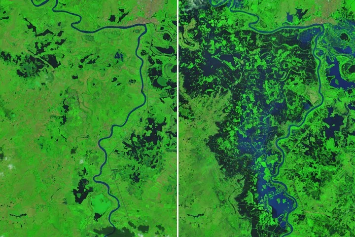
By February 9, 2026, satellite imagery from NASA’s Landsat 9 satellite revealed a stark transformation of the landscape. The Operational Land Imager (OLI) captured a false-color image (using bands 7-5-4, which effectively highlight water and vegetation) showing dark floodwaters consuming agricultural fields, pastures, and residential areas, particularly west of the Sinú River. The vibrant green of healthy vegetation, typically indicative of fertile land, was replaced by the ominous dark blue and black of submerged land, a chilling contrast to the image captured just weeks prior on January 23, before the onset of the floods. The city of Lorica, home to approximately 90,000 residents, appeared perilously close to the encroaching waters in the upper part of the image, underscoring the widespread nature of the threat. To the east, a complex network of wetlands also registered unseasonably high water levels, further evidence of the sheer volume of precipitation that had descended upon the region.
The statistics paint a grim picture of the disaster’s magnitude and its profound impact on human lives and livelihoods. The UN Office for the Coordination of Humanitarian Affairs (OCHA) reported that more than 80 percent of Córdoba department had been affected by the flooding. Preliminary estimates, compiled from news outlets and government sources like Colombia’s National Unit for Disaster Risk Management (UNGRD), indicated the destruction of thousands of homes, the displacement of over 11,000 families, and the inundation of more than 150,000 hectares of vital farmland. The economic backbone of the region—its agriculture and livestock—suffered an immediate and severe blow, with long-term repercussions anticipated for food security and local economies.
Anatomy of an Anomaly: The Meteorological Event
February typically represents one of the driest periods of the year for northern Colombia’s Caribbean coast. It is a crucial window for farmers to prepare their fields for subsequent planting cycles and for ranchers to move their livestock to graze in floodplains that would normally be receding. This period, often characterized by sunny days and reduced rainfall, allows for necessary agricultural activities and natural water management. However, 2026 shattered these established seasonal rhythms. The preceding month, January, had already been unusually wet across Colombia, as noted by the Institute of Hydrology, Meteorology and Environmental Studies (IDEAM), Colombia’s official meteorological agency. This "wet January" set the stage for the catastrophic events that unfolded in February, leaving soils saturated and river levels higher than usual even before the main event.

The primary catalyst for the unprecedented flooding was an unusual cold front that swept south through the Caribbean on February 1 and 2. This atmospheric anomaly, atypical for the time of year and region, acted as a powerful conveyor belt, forcing vast quantities of moisture-laden air inland over northern Colombia. As this moisture encountered the topography of the Andes mountains, it was lifted and cooled, leading to intense and prolonged downpours. Meteorological analyses of the event indicated that some areas within Córdoba received between 4 to 7 centimeters (2 to 3 inches) of rain per day during the initial peak of the storm. This daily rainfall total is significant, especially when sustained over several days in a region accustomed to minimal precipitation during this month.
NASA’s Integrated Multi-satellite Retrievals for Global Precipitation Measurement (IMERG) system provided crucial data, estimating rain rates of up to 1.7 centimeters per hour near Lorica on February 1 – the day that marked the heaviest rainfall. Such hourly rates are indicative of torrential downpours that rapidly overwhelm drainage capacities. While the initial cold front passed, the region continued to experience significant rainfall in the following weeks, albeit with less intensity. By February 25, imagery from NASA’s Terra satellite confirmed that widespread flooding persisted, highlighting the prolonged nature of the crisis and the slow rate of water recession across the broad, flat plains of Córdoba. This sustained saturation prolonged the suffering of communities and compounded the damage to infrastructure and agriculture.
The Sinú River: Lifeline and Destroyer
The Sinú River, a vital artery for the Córdoba department, originates in the Western Andes and flows approximately 335 kilometers (208 miles) northwards before emptying into the Caribbean Sea. Its fertile floodplain has historically been the cradle of agricultural activity and human settlement in the region, supporting a diverse ecosystem and providing sustenance for generations. The river’s annual cycle of rising and falling waters typically dictates farming schedules, with communities adapted to predictable seasonal fluctuations. For centuries, the Sinú has been revered as a source of life, supporting vibrant ecosystems and the region’s economy. However, the early February rains delivered an unmanageable surge, transforming this life-giving river into a destructive force.
The river’s sudden and dramatic overflow caught communities off guard. Homes, many constructed with traditional materials and lacking robust foundations, built close to the riverbanks or within its historical floodplains, were rapidly submerged. Essential infrastructure, including roads, bridges, and local paths, became impassable, effectively isolating affected areas and severely hindering initial relief efforts. The sheer volume of water, combined with the region’s relatively flat topography, meant that the floodwaters had nowhere to recede quickly, creating a vast, stagnant lake across the landscape. This prolonged inundation has devastating effects not only on physical structures but also on the soil quality and long-term agricultural productivity. The economic consequences for the communities dependent on the Sinú’s rhythms are severe, disrupting traditional livelihoods and forcing a reevaluation of future land use in vulnerable areas.
Humanitarian Fallout and Official Response
The human toll of the floods has been substantial and continues to unfold. Thousands of families lost their homes, their possessions, and their means of livelihood in a matter of days. The suddenness and scale of the disaster left many with little time to salvage belongings or secure their livestock. The displacement of over 11,000 families has necessitated the rapid establishment of temporary shelters, often in schools, community centers, or other public buildings, placing immense strain on local resources and infrastructure. Access to clean water, sanitation, and healthcare has become critical concerns, raising fears of waterborne diseases such as cholera, dengue, and leptospirosis, which are common after extensive flooding. Children, the elderly, and those with pre-existing health conditions are particularly vulnerable in these displaced populations, requiring immediate and sustained humanitarian assistance.

Colombia’s National Unit for Disaster Risk Management (UNGRD), in coordination with local authorities and the national military, rapidly mobilized response efforts. Reports from the UNGRD indicated that the atypical cold front had generated 256 emergencies across various departments, with Córdoba being among the most severely impacted, signifying the national scope of the crisis. Emergency teams were deployed to conduct damage assessments, provide humanitarian aid, including food parcels, hygiene kits, and emergency shelter materials, and coordinate rescue operations for stranded individuals. The scale of the disaster, however, stretched the capabilities of regional and national response mechanisms, necessitating a broader call for support from national and international humanitarian organizations.
Local mayors and departmental governors have declared states of emergency, appealing for national and international assistance to address the immediate needs of the affected populations and to embark on the colossal task of recovery. The priority in the immediate aftermath has been to ensure the safety of residents, provide basic necessities such as food, water, and shelter, and prevent the outbreak of epidemics. However, the long-term challenge of rebuilding homes, restoring livelihoods, and reconstructing vital infrastructure looms large, demanding sustained commitment and resources that extend far beyond the initial emergency phase. The psychological trauma experienced by those who have lost everything will also require significant attention as communities begin the arduous journey of recovery.
Economic Devastation and Food Security Concerns
Córdoba is renowned as one of Colombia’s most productive agricultural regions, contributing significantly to the nation’s food supply. The inundation of over 150,000 hectares of farmland represents a catastrophic loss for the department and potentially for national food security. Crops such as rice, corn, plantains, and various vegetables, which form the staple diet and economic backbone of many communities, have been entirely destroyed. The timing of the floods, just as farmers would typically be preparing fields for planting, means that an entire season’s yield could be lost, impacting incomes for months to come and potentially leading to a scarcity of these essential food items. The destruction of irrigation systems, farm equipment, and seed stocks further exacerbates the crisis, making a swift return to farming exceedingly difficult.
The cattle industry, another cornerstone of Córdoba’s economy, has also suffered immense losses. Pasturelands, essential for grazing, were submerged, leaving livestock stranded or forcing ranchers into costly and difficult evacuations. Many animals perished, either drowned or succumbed to disease and lack of sustenance. The loss of feed, the stress on surviving animals, and potential outbreaks of disease pose significant threats to the region’s cattle population, which is among the largest in Colombia. The ripple effects of these agricultural and livestock losses will be felt throughout the supply chain, from local markets to national distribution networks, potentially leading to increased food prices and economic instability for vulnerable populations across the country.
Beyond direct agricultural losses, the disruption to transportation networks has crippled trade and commerce. Roads rendered impassable prevent farmers from bringing any salvaged produce to market and impede the delivery of essential supplies to affected communities. The economic recovery for Córdoba will be a protracted process, requiring substantial investment in agricultural rehabilitation, infrastructure reconstruction, and robust support programs for farmers and ranchers to regain their footing. This includes providing new seeds, financial aid, and technical assistance to help communities rebuild their agricultural capacity in a more resilient manner.
Broader Context: Climate Variability and Future Resilience

The extreme weather event in Córdoba serves as a stark reminder of Colombia’s vulnerability to climate variability and, potentially, the intensifying impacts of global climate change. While localized cold fronts are not entirely unprecedented, their timing and intensity, particularly when combined with an already "wet January," highlight a worrying trend of more erratic and extreme weather patterns. Scientists and climate experts frequently point to such unusual events as consistent with projections for a changing climate, where dry regions may experience more intense rainfall and wet regions face prolonged droughts, disrupting established ecological and agricultural cycles and increasing the frequency of what were once considered rare events.
For a nation like Colombia, which boasts immense biodiversity and a varied climate across its different regions, adapting to these shifts is paramount. The floods in Córdoba underscore the urgent need for enhanced early warning systems, improved water management infrastructure (including flood defenses, drainage systems, and reservoirs), and resilient agricultural practices. Investing in climate-smart agriculture, diversifying crops to include more flood-resistant varieties, and implementing sustainable land management strategies will be crucial for protecting livelihoods and ensuring food security in the face of future climatic challenges. This also includes reforestation efforts in upstream areas to help regulate water flow and prevent soil erosion.
Furthermore, the event provides an opportunity for a comprehensive review of land-use planning, particularly in flood-prone areas. The proximity of settlements and agricultural activities to the Sinú River, while historically beneficial, now presents significant risks in an era of unpredictable weather. This will necessitate difficult conversations about relocating vulnerable communities to safer ground, implementing stricter building codes in areas that remain, and restoring natural flood attenuation features like wetlands and forests that can absorb excess water and act as natural buffers. Such long-term planning must integrate scientific data and community participation to be effective.
Towards Recovery and Reconstruction
As the floodwaters slowly begin to recede, the immediate focus shifts from emergency response to recovery and reconstruction. This phase will be complex and multifaceted, requiring coordinated efforts from national and local governments, humanitarian organizations, and the international community. The psychological impact on displaced families, many of whom have lost everything, will also need significant attention, with mental health support and community-based psychosocial programs being crucial alongside the physical rebuilding of homes and infrastructure.
The experience of Córdoba in early 2026 will undoubtedly serve as a critical case study for disaster risk reduction strategies in Colombia and other vulnerable regions globally. It emphasizes the interconnectedness of meteorological phenomena, hydrological systems, human settlement, and economic activity. Learning from this unprecedented event—understanding its causes, assessing its full impact, and implementing robust recovery and adaptation measures—will be essential to build a more resilient future for the communities along the Sinú River and across Colombia. The path to full recovery will be long and arduous, but it is a journey that must be undertaken with urgency and a forward-looking perspective, aiming not just to rebuild what was lost, but to build back better and stronger against the challenges of a changing world.