


The Mars Science Laboratory (MSL) Curiosity rover is in the final phases of its detailed investigation into the enigmatic "spiderweb-like boxwork unit" within Gale Crater, a crucial segment of its ongoing mission to understand the ancient habitability of Mars. As of the Earth planning date of Friday, March 6, 2026, and reported by William Farrand, Senior Research Scientist at the Space Science Institute, the rover is meticulously exploring the eastern and southern perimeters of this distinctive terrain. This intensive phase of operations involves a series of multi-sol (Martian day) plans designed to characterize the geological features and chemical composition of the region, paving the way for its continued traverse up Mount Sharp. The mission, overseen by a dedicated team of scientists and engineers, continues to unravel the complex geological history of Mars, seeking evidence of past water environments and the building blocks of life.
Unraveling Martian Geology: The Significance of Gale Crater and Mount Sharp
Since its landing in August 2012, the Curiosity rover has been a pivotal instrument in humanity’s quest to understand Mars. Its primary mission is to assess whether Mars ever had an environment capable of supporting microbial life, to characterize the geology and climate of Mars, and to prepare for future human exploration. Gale Crater, Curiosity’s landing site, is a 154-kilometer-wide impact basin featuring a central peak, Mount Sharp (Aeolis Mons), which rises 5.5 kilometers from the crater floor. This central mountain is composed of numerous layers of sedimentary rock, offering a stratigraphic record that scientists interpret as a timeline of Martian environmental history. Each layer potentially holds clues about different eras, from ancient lakes and rivers to more arid conditions.
The "spiderweb-like boxwork unit" represents one such distinct geological layer encountered by Curiosity as it ascends Mount Sharp. In terrestrial geology, "boxwork" structures typically form when minerals precipitate within an interconnected network of fractures or veins in rock. Over time, the surrounding, less resistant rock may erode away, leaving behind a distinctive, often three-dimensional, lattice-like framework of the more durable mineralized veins. On Mars, the discovery and study of such structures are incredibly significant. They can indicate past fluid flow through the Martian crust, suggesting the presence of water or other liquids that deposited these minerals. Analyzing the composition of these mineralized veins can provide direct evidence of the chemistry of these ancient fluids, offering insights into the planet’s hydrological and geochemical evolution. The "spiderweb" descriptor likely refers to the intricate, interconnected nature of these geological formations observed by the rover’s cameras. Understanding the formation and composition of this boxwork unit is critical to reconstructing the environmental conditions that once prevailed in Gale Crater, potentially revealing periods conducive to life.
Recent Operations: Probing the Eastern Frontier
The preceding multi-sol planning cycle saw Curiosity strategically positioned at the eastern extent of the boxwork unit, where mission scientists identified compelling bedrock exposures for in-depth analysis. This phase focused on a bedrock target named "Infiernillo." The rover’s sophisticated suite of scientific instruments was deployed to gather a comprehensive dataset. The Alpha Particle X-ray Spectrometer (APXS) was used to determine the elemental composition of "Infiernillo." APXS works by irradiating the rock surface with alpha particles and X-rays, then analyzing the characteristic X-rays emitted by the atoms in the target, providing precise measurements of elements such as silicon, aluminum, iron, and sulfur. This information is crucial for understanding the mineralogy and geological history of the rock.
Simultaneously, the Mars Hand Lens Imager (MAHLI), mounted on the rover’s robotic arm, captured high-resolution, close-up images of "Infiernillo." MAHLI images are analogous to what a geologist would see through a hand lens on Earth, revealing fine-scale textures, layering, and mineral grains that are invisible to the wider-field cameras. These detailed images, combined with APXS data, provide a micro-context for the chemical measurements. The Chemistry and Camera (ChemCam) instrument, equipped with a Laser-Induced Breakdown Spectrometer (LIBS), also took a chemical measurement of "Infiernillo." ChemCam’s LIBS capability uses a powerful laser to vaporize a tiny spot on the rock surface, creating a plasma whose light is then analyzed to determine the elemental composition remotely. This allows for rapid assessment of targets at a distance, complementing the contact science instruments.
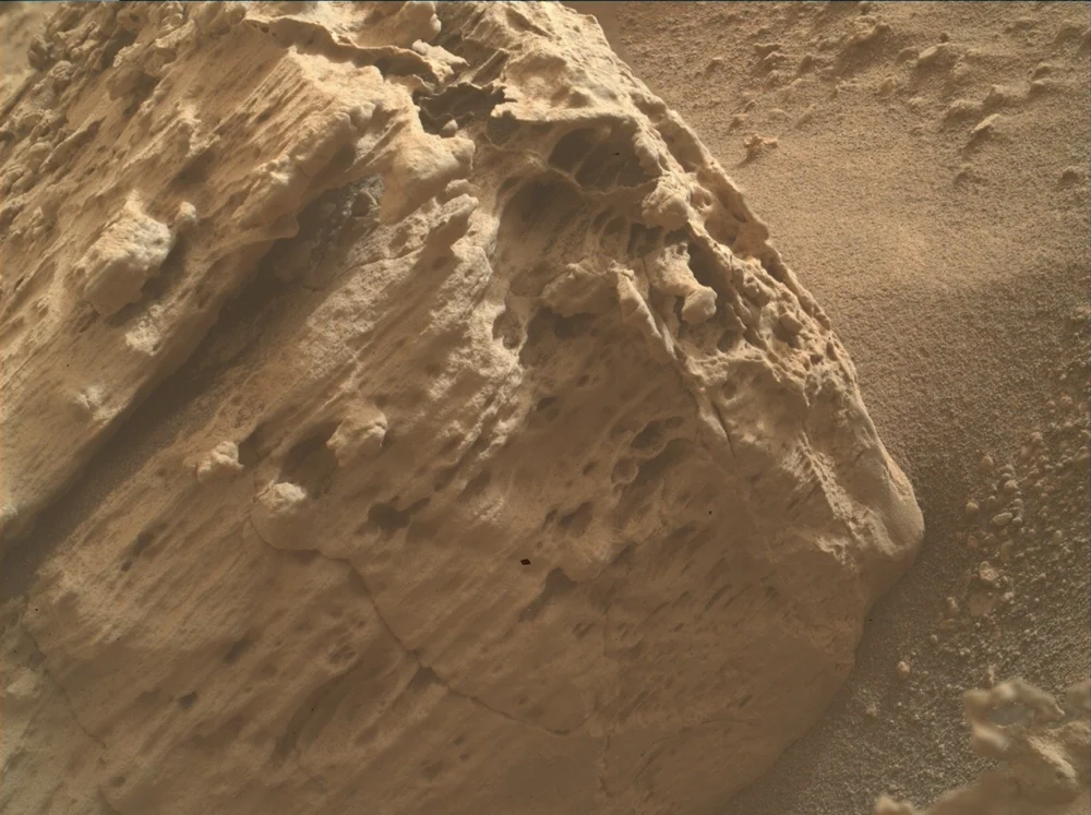
In addition to "Infiernillo," ChemCam LIBS was also directed at "Humahuaca," a nodular-rich piece of bedrock. Nodules in rocks often signify specific geological processes, such as concretionary growth where minerals precipitate around a nucleus, or the alteration of existing minerals. Analyzing their composition can reveal the types of fluids present during their formation and the conditions under which they grew. Furthermore, MAHLI was tasked with imaging a pitted vertical rock face, aptly named "Timboy Chaco." Pitting can result from various erosional processes, including aeolian (wind) erosion or dissolution by fluids. The detailed imagery from MAHLI helps scientists discern the origin of these features and their implications for the rock’s exposure history and interaction with the Martian environment. The MAHLI color image accompanying the original report offered a partial view of this intriguing feature, sparking further scientific curiosity.
Beyond these immediate targets, the Mast Camera (Mastcam) and ChemCam’s Remote Micro-Imager (RMI) collected extensive color mosaics. Mastcam provides panoramic color images of the Martian landscape, offering crucial contextual information about the rover’s surroundings. RMI, working in conjunction with ChemCam’s LIBS, provides high-resolution black-and-white images of distant targets, allowing for detailed observation of features that are out of reach of the robotic arm. These mosaics were instrumental in characterizing the nearby terrain, including a prominent butte to the south, and critically, mapping the geological contact between the distinct boxwork terrain and an adjacent layered, light-toned unit. Identifying and characterizing such contacts is fundamental to stratigraphy, allowing scientists to understand the sequence of geological events and how different units relate to each other in time and formation. The light-toned unit, often associated with sulfate-rich rocks in other parts of Mount Sharp, could represent a different aqueous environment or a later stage of desiccation.
Midweek Maneuvers and the Southern Trajectory
Following these intensive observations, a carefully executed midweek drive propelled Curiosity further along the eastern edge of the boxwork unit. This strategic maneuver was designed not only to advance the rover’s exploration but also to position it optimally for subsequent drives towards the southern boundary of the boxwork. The rover’s mobility system, consisting of six independently driven and steered wheels, allows for precise navigation across challenging Martian terrain, including sandy patches, rocky outcrops, and varying slopes. Each drive is meticulously planned by a team of drivers and engineers, considering terrain hazards, power constraints, and scientific objectives.
The workspace available for Friday’s planning presented a new array of geological features, including fresh bedrock exposures and, notably, a dark-toned float rock. Float rocks are individual rocks that are not attached to bedrock, often transported from their original location by erosion, impacts, or other geological processes. This particular float rock, dubbed "Thola," immediately captured the attention of the science team due to its distinctive dark coloration and substantial size. Its dimensions were sufficient for comprehensive in-situ observation by APXS, allowing for a detailed elemental composition analysis. Furthermore, MAHLI was tasked to acquire up-close images, revealing its surface textures and any fine-scale features that might hint at its origin. ChemCam was also directed to measure "Thola’s" reflectance properties. Reflectance spectroscopy, analyzing how light interacts with the rock’s surface, can provide clues about its mineralogy and overall composition.
The heightened interest in "Thola" stems from a compelling hypothesis: some dark float rocks previously observed by Curiosity in the past year have been interpreted as potential stony meteorites, specifically chondrites. Chondrites are a class of stony meteorites that have not been modified by melting or differentiation since their formation, representing some of the most primitive materials in the solar system. Their presence on Mars, if confirmed, offers invaluable insights. They could be remnants of the early solar system, delivered to Mars via impacts, or they could tell us about the flux of meteoritic material impacting Mars over geological timescales. Measuring the chemistry and reflectance of "Thola" is therefore a critical step. By comparing its elemental composition and spectral signature to known Martian rocks and terrestrial meteorites, the team aims to definitively determine whether "Thola" is indigenous to Mars or an extraterrestrial visitor. This distinction carries profound implications for understanding Martian surface processes, weathering, and the broader history of celestial impacts.
Deeper Insights into Bedrock and Future Pathfinding
The Friday plan extended beyond "Thola," incorporating further remote chemistry measurements by ChemCam on other bedrock targets. "Valle Fertil," a smooth bedrock target, was chosen for its uniform appearance, which often suggests specific formation processes or degrees of alteration. Conversely, "Norte Grande," a nodular bedrock target, presented an opportunity to compare its composition with "Humahuaca" and further investigate the formation mechanisms and chemical makeup of these intriguing concretions.
Mastcam continued its crucial role in geological mapping, acquiring mosaics of light-toned bedrock exposures located across the eastern contact of the boxwork unit. These mosaics are vital for assessing sedimentary structures—features like cross-bedding, ripple marks, or laminations—which provide direct evidence of depositional environments, such as ancient rivers, lakes, or wind-blown dunes. By analyzing these structures, scientists can reconstruct the dynamics of water or wind that shaped the Martian landscape billions of years ago. Simultaneously, these observations contribute to determining stratigraphic relationships, helping to build a comprehensive geological column for the region. Additional Mastcam mosaics were collected to observe smaller troughs in the regolith (the loose surface material covering the bedrock) and other nearby ridges, offering further context on erosional patterns and geological evolution. A specific two-frame mosaic was also dedicated to capturing "Thola" and another dark-toned pebble, providing a broader field of view for these potentially significant dark rocks.
The comprehensive planning for this phase of exploration underscores the meticulous approach of the MSL mission team. Every instrument is utilized strategically, and every observation contributes to a larger scientific narrative. The combination of close-up "contact science" (APXS, MAHLI) and remote sensing (ChemCam, Mastcam) allows for a multi-scale understanding of the Martian environment, from the microscopic details of mineral grains to the panoramic vista of Mount Sharp.
Towards the Southern Boundary: The Next Chapter
The final component of the current multi-sol plan involves a significant drive towards the southern border of the boxwork unit. This next major leg of the journey is estimated to cover approximately 100 meters (about 109 yards). Given the typical challenges of Martian terrain and the need for careful navigation and intermediate science stops, mission planners anticipate that this traverse will likely require at least two distinct drives. Each drive is carefully simulated and validated on Earth using a test rover in a Mars yard, ensuring safety and efficiency.
The transition from the "spiderweb-like boxwork unit" to the southern border marks a new chapter in Curiosity’s exploration of Mount Sharp. The scientific objectives for this next region will undoubtedly focus on characterizing the geology of the adjacent terrain, investigating how it relates to the boxwork unit, and continuing the search for evidence of past habitable environments. The southern contact could reveal different sedimentary layers, altered mineral compositions, or unique geomorphological features that offer fresh clues about Mars’s ancient past.
The insights gained from the boxwork unit, from the chemical fingerprints of "Infiernillo" and "Humahuaca" to the textural details of "Timboy Chaco," and the potential extraterrestrial origin of "Thola," are all pieces of a grander puzzle. Each piece contributes to a more nuanced understanding of Mars’s transition from a potentially warm, wet world capable of supporting life to the cold, arid planet we observe today. The Mars Science Laboratory mission continues to push the boundaries of planetary science, delivering groundbreaking data that reshapes our understanding of the Red Planet and its place in the solar system. The meticulous work of the mission team ensures that every Martian sol is maximized for scientific discovery, building a legacy of exploration that will inform future human and robotic missions for decades to come.