


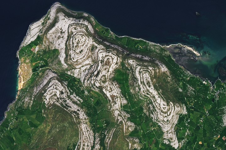
The striking gray expanse of Ireland’s Burren region, captured in a recent satellite image by NASA’s Landsat 8, offers a stark, beautiful contrast to the verdant landscapes for which the Emerald Isle is globally renowned. While Ireland is celebrated for its myriad shades of green, this unique corner on its western coast, specifically highlighted as the Image of the Day for March 17, 2026, presents a captivating geological anomaly that stands out even from orbital perspectives. The Operational Land Imager (OLI) on Landsat 8 acquired this detailed view of the Burren on May 16, 2025, revealing the intricate patterns of its limestone pavement, a natural wonder that has long fascinated geologists, botanists, and cultural historians alike.
A Deep Dive into Ancient Origins: The Carboniferous Legacy
The narrative of the Burren’s distinctive gray landscape begins approximately 325 million years ago, during the Carboniferous Period. At this ancient juncture in Earth’s history, the landmass that would eventually become Ireland was situated much closer to the equator, submerged beneath warm, shallow tropical seas. This environment was teeming with marine life, including countless shells, corals, and other calcium carbonate-rich organisms. As these organisms died, their skeletal remains accumulated on the seafloor, layer upon layer, slowly compressing and cementing over millennia to form the thick, fossil-rich limestone that defines the Burren today. This process, known as marine sedimentation, laid down vast, initially flat and horizontal beds of rock, preserving a remarkable record of Carboniferous marine ecosystems within their strata. The abundance of fossils, from crinoids to brachiopods, serves as a tangible link to this distant tropical past, offering paleontologists invaluable insights into the life forms that thrived in these prehistoric oceans.
Tectonic Forces and Glacial Sculpting: Shaping the Modern Landscape
The journey from a tropical seabed to the exposed, fissured landscape of the Burren involved colossal geological forces. Millions of years after its initial deposition, the limestone underwent significant transformation during the Variscan Orogeny, a major mountain-building event that affected much of Western Europe and parts of North America. This period of intense tectonic activity, occurring roughly 300 to 250 million years ago, saw continental plates collide, subjecting the horizontally laid limestone to immense pressure. The once-flat layers buckled and folded into gentle arch-shaped anticlines and trough-shaped synclines, giving the bedrock a subtle undulation that is still evident in the terraced hills of the Burren. These folds, combined with differential erosion rates where some rock layers were more resistant to weathering than others, produced the characteristic step-like ledges and terraces that define the region’s topography.
Following the Variscan Orogeny, subsequent geological epochs, particularly the Pleistocene glaciations, played a crucial role in further sculpting the Burren. Over the past 2.6 million years, multiple ice ages saw vast sheets of ice advance and retreat across Ireland. These powerful glaciers acted as enormous bulldozers, scraping away overlying soil, sediment, and any softer rock layers, effectively stripping the landscape bare and exposing the underlying limestone pavement. The abrasive action of the ice, laden with rock debris, smoothed the region’s hills and etched striations into the exposed bedrock, leaving behind a testament to the immense power of glacial erosion. This glacial scouring is critical to understanding the Burren’s current appearance, as it removed the protective layer of soil that would typically support dense vegetation, thus revealing the stark, treeless rock formations.
Karst Topography: A Labyrinth of Rock and Life
The exposed limestone, a soluble rock, is highly susceptible to chemical weathering, primarily by rainwater which becomes weakly acidic as it absorbs carbon dioxide from the atmosphere and soil. This process, known as carbonation, slowly dissolves the limestone, creating a distinctive landscape type called karst. The Burren is one of the finest examples of glacio-karst terrain in the world, characterized by a unique array of surface and subsurface features.
Central to the Burren’s karst topography are the "limestone pavements," vast expanses of exposed bedrock fissured by a grid-like network of cracks. These cracks are known as grikes, and the blocks of limestone separating them are called clints. Rainwater, channeling into these grikes, deepens and widens them over time, creating a labyrinthine pattern across the landscape. While too small to be individually resolved by Landsat imagery, the cumulative effect of these grikes, often aligning along natural weaknesses or bedding planes in the rock, contributes to the subtle concentric vegetation patterns visible from space.
Beyond grikes and clints, the Burren’s karst system includes numerous sinkholes or dolines, depressions where surface water drains directly into underground channels. These can vary in size from small dimples to large, bowl-shaped formations. The region is also riddled with an extensive network of caves and subterranean rivers, some of which are among the longest in Ireland, indicating a complex hydrological system beneath the seemingly barren surface. These underground features are a testament to millions of years of water erosion, creating a hidden world of speleological wonders. The seasonal nature of some of the Burren’s rivers, appearing after heavy rainfall and disappearing underground, further illustrates the dynamic interaction between surface water and the soluble bedrock.
An Ecological Enigma: Where Arctic Meets Mediterranean
Despite its outwardly stark appearance, the Burren harbors an astonishingly rich and unique biodiversity, making it an ecological enigma. The microclimates created within the grikes play a crucial role in supporting this diverse flora. The deep fissures trap pockets of soil and offer shelter from the prevailing winds, providing a moist, cool environment in contrast to the exposed, sun-drenched clints. This allows for the coexistence of plant species with vastly different ecological requirements, a phenomenon rarely observed elsewhere.
Botanists have documented a remarkable assemblage of flora in the Burren, where Arctic-Alpine plants, typically found in cold, mountainous regions, grow side-by-side with Mediterranean species, usually associated with warmer, southern climates. Examples include the mountain avens (Dryas octopetala), an Arctic-Alpine relic from the last ice age, thriving alongside the dense-flowered orchid (Neotinea maculata), a species with a predominantly Mediterranean distribution. Other notable species include the spring gentian (Gentiana verna), known for its vibrant blue flowers, and various ferns and mosses that cling to the moist sides of the grikes.

The presence of the shamrock, Ireland’s enduring national symbol, further ties the Burren to the nation’s cultural identity. While individual grikes are too small for satellite resolution, the broader patterns of vegetation growth within their networks contribute to the overall visual tapestry. The article specifically mentions the possibility of finding Trifolium dubium or Trifolium repens, two clover species often considered candidates for the "true" shamrock, amidst the shamrock-shaped contours of Moneen Mountain, an 860-foot limestone hill within the image. According to the Carnegie Museum of Natural History, an 1880s survey of Irish botanists favored these two species, highlighting the long-standing debate and cultural significance surrounding this iconic plant. The Burren’s unique environment, with its sheltered, moist grikes, provides ideal conditions for various clover species to flourish, reinforcing its connection to this national emblem.
A Landscape Shaped by Human Hand and Tradition
The Burren’s landscape is not solely a product of natural forces; it has also been shaped by millennia of human interaction. Archaeological evidence suggests human habitation dating back to the Neolithic period, with numerous megalithic tombs (dolmens), ringforts, and monastic settlements scattered across the region. These ancient structures stand as silent witnesses to the ingenuity and resilience of past communities who adapted to and thrived in this challenging environment.
One of the most remarkable aspects of human adaptation in the Burren is the traditional farming practice known as "winterage." Unlike typical farming where livestock are moved indoors during winter, in the Burren, cattle are traditionally moved to the upland limestone pastures for the colder months. The limestone, naturally warmer than other soil types, combined with the shelter offered by the grikes, provides a suitable grazing environment. This practice, passed down through generations, helps to maintain the Burren’s unique botanical diversity by preventing scrub encroachment and allowing light to reach the smaller, more delicate plants in spring. This symbiotic relationship between human activity and natural ecosystem is a hallmark of the Burren’s cultural landscape.
Official Recognition and Conservation Efforts
The exceptional geological, ecological, and cultural significance of the Burren has earned it widespread recognition and concerted conservation efforts. A significant portion of the region is protected as the Burren National Park, established to conserve its unique habitats and species. Furthermore, in 2011, the Burren and Cliffs of Moher were designated a UNESCO Global Geopark, acknowledging its international geological importance and its role in sustainable development through geotourism and education.
The UNESCO designation underscores the area’s value not only as a natural heritage site but also as a living laboratory for understanding geological processes, climate change impacts, and the delicate balance between human activity and environmental preservation. Organizations such as the Burren Ecotourism Network and the Burren Programme work collaboratively with local communities, farmers, and scientists to promote sustainable practices, support biodiversity, and educate visitors about the region’s unique attributes. These efforts aim to balance the increasing influx of tourists, drawn by the Burren’s stark beauty and the iconic Cliffs of Moher, with the imperative to protect its fragile ecosystems.

Satellite Technology: A Vital Tool for Earth Observation
The capture of the Burren by Landsat 8’s Operational Land Imager (OLI) on May 16, 2025, exemplifies the critical role of satellite technology in modern Earth observation. Landsat satellites, a joint mission of NASA and the U.S. Geological Survey (USGS), have been providing continuous imagery of Earth’s land surface since 1972, creating an invaluable archive of environmental change.
The OLI instrument on Landsat 8 captures images across nine spectral bands, from visible light to shortwave infrared. This multi-spectral capability allows scientists to differentiate between various land cover types, monitor vegetation health, track hydrological features, and discern subtle geological patterns that might be invisible to the naked eye or from conventional aerial photography. In the case of the Burren, the OLI’s resolution enables the identification of the broad gray expanses of limestone, the darker linear patterns indicative of vegetation-filled grikes, and the overall terraced structure of the hills, providing a comprehensive view of this complex landscape. Such data is instrumental for geological mapping, ecological monitoring, and informing conservation strategies, allowing researchers to track changes over time and better understand the dynamic processes shaping our planet.
Conclusion: A Gray Jewel in the Emerald Isle
The Burren stands as a powerful testament to the Earth’s geological history and the enduring power of natural processes. From its origins as a tropical seabed 325 million years ago, through periods of immense tectonic upheaval and glacial sculpting, to its present-day form as a karstic wonderland, this region offers a living textbook of Earth science. The NASA Earth Observatory’s Image of the Day for March 17, 2026, featuring the Burren, not only highlights its stark, captivating beauty from space but also serves as a reminder of the intricate connections between geology, ecology, and human culture. This "gray jewel" on Ireland’s west coast, with its unique blend of Arctic and Mediterranean flora, ancient archaeological sites, and sustainable farming traditions, continues to inspire wonder and reinforce the importance of preserving our planet’s most extraordinary landscapes for future generations.