

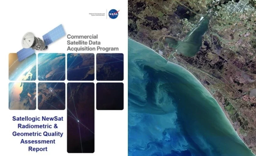
A pivotal report from NASA’s Commercial Satellite Data Acquisition (CSDA) program, issued on March 9, 2026, has formally approved the utilization of data from Satellogic’s NewSat constellation, specifically encompassing its Mark IV and Mark V sensor generations, for a broad spectrum of scientific applications. This landmark decision marks a significant advancement in NASA’s ongoing strategy to integrate commercial remote sensing data into its Earth science research, promising to accelerate discovery and enhance our understanding of the planet. The approval follows a rigorous evaluation process conducted by NASA’s subject matter experts (SMEs), culminating in the release of the Commercial Satellite Data Acquisition Program Satellogic NewSat Radiometric & Geometric Quality Assessment Report.
A Deep Dive into the Quality Assessment Report
The comprehensive report meticulously details the findings from an extensive evaluation of Satellogic’s data products. Over a period spanning from 2021 to 2025, NASA’s SMEs analyzed 60 top-of-atmosphere reflectance images acquired by the NewSat constellation. This substantial dataset allowed for a thorough assessment of both radiometric and geometric performance across diverse geographical sites and environmental conditions. The primary objective was to ascertain the data’s suitability for the high-precision demands of scientific research, which often requires consistent accuracy and reliability.
Radiometric accuracy, a critical parameter for quantitative Earth science applications, was a central focus of the assessment. The results showcased generally strong performance from the NewSat constellation. A significant finding was that the majority of Satellogic’s spectral bands demonstrated radiometric accuracy within 10% of reference values obtained from the Aqua Moderate Resolution Imaging Spectroradiometer (MODIS) instrument. Aqua MODIS, a cornerstone of NASA’s Earth Observing System since its launch in 2002, is renowned for its long-term, well-calibrated, and scientifically validated data record, making it an ideal benchmark for assessing the radiometric fidelity of new commercial sensors. Meeting this stringent benchmark underscores the scientific utility of Satellogic’s data. Furthermore, the report noted that signal-to-noise ratios (SNR) for more than half of the spectral bands met the "Good" rating criteria. A high SNR is crucial for distinguishing genuine environmental signals from background noise, particularly in challenging imaging conditions or for subtle changes in Earth’s surface properties, thereby enhancing the data’s analytical value.
Geometric performance, which pertains to the spatial accuracy and precision of the imagery, also received close scrutiny. The assessment revealed that Satellogic’s NewSat sensors generally exceeded their specified sensor spatial response specifications. This indicates a high degree of precision in positioning observed features on Earth’s surface, a fundamental requirement for applications like land-use mapping, change detection, and disaster response. However, the report also highlighted some variability in geometric performance between different sensor generations within the NewSat constellation. Specifically, the Mark IV sensor generation received an "Excellent" grade for its sensor spatial response, indicating exceptionally high geometric fidelity. In contrast, the Mark V generation was assigned a "Basic" grade in the same category. This distinction, while noting an overall strong performance, points to potential differences in sensor design, calibration, or processing chains between the two generations that could impact certain high-precision geometric analyses.
Satellogic’s Proactive Response and Ongoing Evaluation
In a testament to the collaborative spirit fostered by the CSDA program, Satellogic has already taken proactive steps to address the findings and recommendations outlined in the quality assessment report. Since the report’s release, the company has implemented changes to aspects of its data processing workflows. This swift response demonstrates Satellogic’s commitment to continuous improvement and its dedication to aligning its data products with NASA’s rigorous scientific standards.
The CSDA program, true to its mission of fostering innovation and ensuring data quality, is currently engaged in a follow-up quality assessment of Satellogic’s revised products. This ongoing evaluation will scrutinize the impact of the implemented changes on both radiometric and geometric performance. NASA anticipates reporting on the results of this renewed assessment in the near future, providing the scientific community with updated insights into the enhanced capabilities of the NewSat constellation. This iterative process of evaluation, feedback, and improvement is a hallmark of the CSDA program, designed to continuously elevate the quality and utility of commercial Earth observation data for scientific research.
The Strategic Imperative: NASA’s Commercial Satellite Data Acquisition Program
The approval of Satellogic’s data is not an isolated event but rather a significant milestone within the broader strategic framework of NASA’s Commercial Satellite Data Acquisition (CSDA) program. Established by NASA’s Earth Science Division (ESD), the CSDA program was conceived to systematically identify, evaluate, and acquire commercial remote sensing data that can effectively augment and enhance NASA’s extensive portfolio of Earth science research and applications. In an era of burgeoning commercial space capabilities, the CSDA program acts as a crucial bridge, connecting NASA’s scientific imperatives with the innovative capacities of the private sector.
The program provides structured "on-ramping" opportunities for emerging commercial satellite data vendors, offering a clear pathway for these companies to engage with NASA. This mechanism enables NASA to continuously integrate innovative and complementary data sources as the private sector rapidly evolves, often at a pace unachievable through traditional government procurement cycles. By strategically leveraging these partnerships, NASA’s ESD aims to achieve several critical objectives: primarily, to accelerate scientific discovery across various Earth science disciplines, and secondarily, to expand the applications of Earth observation data for the benefit of both the NASA Earth science research community and broader societal needs. This includes areas such as climate change monitoring, natural hazard prediction, resource management, and agricultural productivity.
Since its initial pilot phase, the CSDA Program has successfully conducted three on-ramp activities, leading to the integration of several commercial vendors into its sustainment phase. This programmatic evolution reflects a maturing approach to commercial data acquisition. A key improvement has been the streamlining of its evaluation process through the introduction of high-quality, SME-led data assessments. These expert-driven reviews significantly accelerate the evaluation timeline while simultaneously strengthening NASA’s engagement with the rapidly growing commercial data ecosystem. The CSDA’s comprehensive evaluation criteria typically encompass not only radiometric and geometric quality but also factors such as data accessibility, format compatibility, mission relevance, and the vendor’s long-term sustainability. This holistic approach ensures that NASA gains timely access to high-quality, mission-relevant commercial data. Concurrently, the program provides invaluable feedback to private-sector providers, a mechanism that actively fosters innovation, drives the improvement of data products, and aligns industry capabilities with NASA’s evolving scientific and operational needs.
The Broader Implications for Earth Science and Commercial Space
The formal approval of Satellogic’s NewSat data by NASA carries significant implications for both the scientific community and the commercial space industry. For Satellogic, this validation from one of the world’s foremost scientific agencies provides immense credibility. It not only opens doors to potential NASA contracts and collaborations but also enhances its standing in the global Earth observation market, potentially attracting other government agencies, research institutions, and commercial clients seeking reliable and scientifically vetted data. The feedback received from NASA, particularly regarding the Mark V sensor’s geometric performance, offers a clear roadmap for further product enhancement, ensuring that Satellogic can continue to refine its offerings to meet the most demanding scientific specifications.
For NASA, the integration of Satellogic’s data represents a crucial step in diversifying its Earth observation assets. While NASA maintains a robust fleet of its own Earth-observing satellites, commercial constellations like NewSat offer unique advantages, including potentially higher revisit rates, finer spatial resolutions for certain applications, and increased data volumes, which can complement traditional government missions. This diversified data portfolio enhances NASA’s ability to monitor dynamic Earth processes, such as rapidly evolving natural disasters, urban expansion, and agricultural changes, with greater frequency and detail. It also validates the efficacy of the CSDA program’s model, demonstrating that strategic partnerships with the private sector can indeed yield high-quality data suitable for cutting-edge scientific research.
More broadly, this development sends a strong signal to the entire commercial Earth observation sector. It underscores NASA’s commitment to leveraging private-sector innovation and establishes a clear benchmark for data quality and scientific utility. This encourages other commercial providers to invest in robust calibration, validation, and quality assurance processes, knowing that meeting NASA’s standards can unlock significant opportunities. The collaborative model, where NASA provides expert assessment and feedback, acts as a catalyst for industry-wide improvement, ultimately benefiting the global scientific community with an ever-expanding array of high-quality, accessible Earth observation data.
The continued success of programs like CSDA is vital for advancing our collective understanding of Earth’s complex systems. As the planet faces unprecedented environmental challenges, from climate change to biodiversity loss, the availability of comprehensive, accurate, and timely Earth observation data is more critical than ever. Partnerships between government agencies and commercial entities are proving to be an efficient and effective means of addressing these data needs, fostering a dynamic ecosystem where innovation flourishes and scientific discovery is accelerated for the benefit of society.
Additional Resources
For a comprehensive understanding of the assessment, the full Satellogic NewSat Radiometric & Geometric Quality Assessment Report is available for public access. Interested parties can visit the CSDA website to read the detailed findings and methodology. Furthermore, a recent CSDA Vendor Focus Webinar featuring Satellogic offers additional insights into the company’s capabilities and its engagement with NASA, accessible on the CSDA program’s YouTube channel. For more information regarding the CSDA program’s process for identifying and evaluating commercial satellite vendors, and its overarching mission, resources are available on the CSDA website, highlighting NASA’s commitment to a transparent and collaborative approach to commercial data acquisition.