


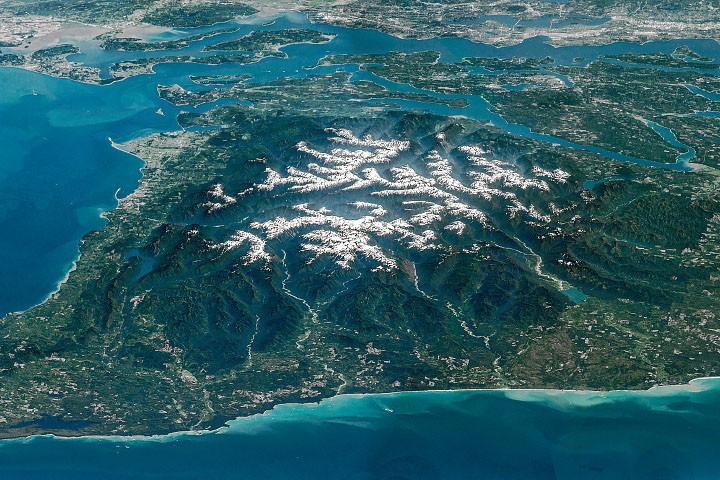
Snow-capped mountains, dramatically carved by deep river valleys, stand as a formidable sentinel over northwestern Washington state, a landscape vividly captured in a stunning composite image from the International Space Station (ISS) designated as the Image of the Day for July 23, 2026. This oblique perspective offers a rare glimpse into the complex interplay of geological forces and ecological diversity that defines the Olympic Peninsula, a region where alpine glaciers, wild coastlines, temperate rainforests, and expansive river systems coexist within a relatively remote bastion of wilderness. Surrounded by the blue waters of the Pacific Ocean, the Strait of Juan de Fuca, and Puget Sound, alongside peaceful islands and burgeoning population centers, the peninsula’s rugged interior has largely retained its pristine character, making it a critical area for environmental study and conservation.
Capturing the View from Orbit: A NASA Perspective
The captivating image, a testament to humanity’s orbital vantage point, was meticulously assembled from several sequential, overlapping photographs taken by an astronaut aboard the ISS. This composite technique allowed for the creation of a seamless panorama, offering a comprehensive view of the Olympic Mountains’ imposing terrain. NASA’s Earth Science and Remote Sensing Unit at Johnson Space Center processed these astronaut photographs (specifically ISS047-E-104138 through ISS047-E-104144), originally acquired on May 6, 2016, using a Nikon D4 digital camera with a focal length of 400 millimeters. The ISS Crew Earth Observations Facility plays a crucial role in this process, supporting the ISS National Lab’s mission to facilitate the acquisition of Earth imagery for scientific research and public engagement. These images are carefully cropped, enhanced for contrast, and lens artifacts are removed to ensure their highest value, making them freely accessible online through the NASA/JSC Gateway to Astronaut Photography of Earth. Such imagery provides invaluable data for monitoring environmental changes, understanding geological processes, and educating a global audience about the planet’s diverse landscapes.
A Tapestry of Ecosystems: The Olympic Peninsula’s Unique Geography
The Olympic Peninsula is a marvel of natural diversity, often referred to as "an island in the sky" due to its distinct ecological zones. The region encompasses a staggering array of biomes within a relatively small geographical area. At its core lies Olympic National Park, a UNESCO World Heritage Site and International Biosphere Reserve, which protects the mountainous heartland and significant stretches of its Pacific coastline. Beyond the park’s boundaries, much of the remaining land falls under the stewardship of national forests (Olympic National Forest), state-owned lands, or vital tribal territories, including those of the Quinault, Hoh, Quileute, and Makah nations, whose histories and cultures are deeply intertwined with the land and its resources.
This unique geographical positioning, coupled with the Olympic Mountains’ height, creates dramatic climatic variations. The western flanks of the mountains intercept moisture-laden air from the Pacific, leading to some of the wettest conditions in the continental United States, fostering lush temperate rainforests. Conversely, the eastern slopes lie in a rain shadow, resulting in drier, more open forest environments. This striking contrast in precipitation and vegetation contributes significantly to the peninsula’s exceptional biodiversity, supporting endemic species found nowhere else on Earth.
Geological Origins and Ongoing Forces: A Story of Uplift and Erosion
The very bedrock of the Olympic Mountains tells a story rooted deep beneath the ocean’s surface. Geologists explain that from approximately 55 to 15 million years ago, vast layers of basalt, extruded from undersea volcanic eruptions, and massive deposits of sand and mud, transported seaward by ancient rivers, accumulated on the Pacific ocean bottom. This material was not destined to remain submerged. The region lies at a dynamic tectonic boundary where the Juan de Fuca plate is actively subducting, or diving, beneath the North American plate.
As the Juan de Fuca plate descended, these accumulated marine sediments and volcanic rocks were not carried down with it entirely. Instead, they were scraped off, much like soil being pushed by a bulldozer, and subsequently crumpled, folded, and thrust upwards. This immense pressure and deformation gradually gave rise to the towering Olympic Mountains, with peaks now reaching over 8,000 feet (2,440 meters) above sea level. Mount Olympus, the highest point, stands at 7,980 feet (2,432 meters), a testament to these powerful, ongoing geological forces.
Even today, tectonic activity continues to exert upward pressure, pushing the mountains skyward. However, this uplift is counterbalanced by the relentless forces of erosion, particularly in this exceptionally rainy and snowy corner of the country. The constant interplay between uplift and erosion creates a dynamic equilibrium, perpetually shaping the landscape. This delicate balance means that while the land is still technically rising, the visible effects of erosion—primarily through glacial action and river incision—are equally profound, preventing the mountains from growing indefinitely higher.
The Retreating Giants: Glaciers and Climate Change
A significant agent of erosion in the higher elevations of the Olympic Mountains is glaciation. Snowfall at these altitudes accumulates and compacts, forming glaciers that slowly flow downhill, carving out U-shaped valleys, cirques, and arêtes in the underlying rock. These glaciers are not merely static ice masses but dynamic features, integral to the hydrological cycle of the peninsula, feeding numerous rivers and streams.
However, scientific observations over recent decades paint a concerning picture of their decline. Glaciers in the Olympics, like many worldwide, are unequivocally retreating and thinning at an accelerated rate, and their overall numbers are shrinking. A comprehensive study published in 2022 (DOI: 10.1029/2022JF006670) meticulously cataloged 255 glaciers and perennial snowfields within the Olympic Range in 2015. Alarmingly, the same study revealed that 35 glaciers and 16 perennial snowfields had completely vanished in the preceding 35 years alone. This represents a substantial loss, highlighting the tangible impacts of a warming climate on even relatively resilient mountain environments.
The implications of this glacial retreat are far-reaching. Glaciers act as natural reservoirs, storing winter precipitation and releasing meltwater during drier summer months, which is crucial for maintaining river flows, supporting aquatic ecosystems, and providing freshwater resources. Their disappearance can lead to altered stream temperatures, reduced summer flows, and habitat loss for cold-water species like salmon and trout, impacting the entire ecological web of the peninsula. Monitoring these changes from space, as facilitated by images like the one featured, provides critical data for climate scientists and conservationists.
River Valleys: Lifelines and Ancient Forests
The profound effects of erosion are strikingly evident in the deep, verdant river valleys that radiate outwards from the snowy peaks. The Hoh, Queets, and Quinault rivers, all prominently visible in the ISS image and draining westward into the Pacific Ocean, exemplify this erosional power. These rivers have carved intricate networks through the landscape, creating fertile floodplains and supporting some of the most spectacular temperate rainforests on Earth.
The temperate rainforests of the Olympic Peninsula are characterized by immense trees, often cloaked in thick mosses and ferns, thriving under conditions of high rainfall and moderate temperatures. The Hoh River valley, in particular, is renowned for its ancient forest, a prime example of this unique ecosystem. Historically, parts of the Hoh River valley were considered among the most naturally quiet places in the United States, largely undisturbed by human-caused noise. This exceptional tranquility underscores the importance of preserving these remote wilderness areas not only for their biodiversity but also for the increasingly rare experience of natural silence, a vital component of ecological health and human well-being. These rainforests are biodiversity hotspots, providing habitat for a diverse array of flora and fauna, including Roosevelt elk, various species of Pacific salmon, and numerous bird species.
The Elwha River: A Story of Restoration and Resilience
Flowing to the north, the Elwha River holds a rich tapestry of natural and human history, making it a focal point for understanding the interplay between human development and environmental stewardship. The Elwha played a significant role in some of the earliest Euro-American exploration of the Olympics. Notably, a Seattle newspaper sponsored an expedition from December 1889 to May 1890, which embarked on an ambitious journey to cross the mountain range from north to south. Traveling up the Elwha valley and descending the Quinault, the party faced immense challenges, spending several arduous months in the Elwha Valley, their progress severely hampered by an unusually harsh and snowy winter.
In the early 1900s, the Elwha Valley attracted entrepreneurs who recognized its economic potential. Two hydroelectric dams, the Elwha Dam and the Glines Canyon Dam, were constructed on the river in 1910 and 1927, respectively, to produce power for local industries, particularly logging and paper mills. While these structures brought economic benefits, they came at a profound environmental cost. The dams completely blocked the migration of once-abundant trout and five species of Pacific salmon (Chinook, coho, sockeye, chum, and pink) to their ancestral spawning grounds in the upper reaches of the river, devastating fish populations and the broader riverine ecosystem. The dams also trapped sediment, altering the river’s natural flow and impacting downstream deltas and coastal areas.
Recognizing the severe ecological damage and the importance of salmon to both the ecosystem and the cultural heritage of the Lower Elwha Klallam Tribe, a monumental decision was made. In 2011 and 2014, in what was then the largest dam removal project in U.S. history, both the Elwha Dam and the Glines Canyon Dam were systematically decommissioned and removed. This ambitious undertaking initiated a remarkable process of ecological restoration. Since the dams’ removal, scientists and conservationists have diligently worked to restore fish populations, seed native plant communities along the newly exposed riverbanks, and replenish sediment flow, which is crucial for rebuilding beaches and estuaries. Early results have been overwhelmingly positive, with salmon returning to spawn in areas they had not reached for over a century, demonstrating the resilience of natural systems when given the opportunity to recover. The Elwha River restoration project serves as a global model for large-scale river ecosystem recovery, offering invaluable lessons for future environmental initiatives.
Strategic Waterways: The Strait of Juan de Fuca and Regional Connectivity
The mouth of the Elwha River forms a delta in the Strait of Juan de Fuca, a vital waterway bordering the Olympic Peninsula to the north. This expansive channel, ranging from 11 to 17 miles (18 to 27 kilometers) wide, holds significant geographical and economic importance. The U.S.-Canada border runs directly through the middle of the strait, with Vancouver Island in British Columbia lying to the north.
The Strait of Juan de Fuca acts as a critical marine artery, connecting the vast Pacific Ocean with the intricate network of the Strait of Georgia and Puget Sound. This connectivity makes it an indispensable route for ship traffic, providing access to major West Coast ports, including the bustling hubs of Seattle and Tacoma, which are visible along the top-right edge of the ISS image. These ports are economic powerhouses, facilitating international trade and contributing significantly to the regional economy. Beyond commerce, the strait is also a rich marine environment, supporting diverse wildlife, including resident orcas, various marine mammals, and a plethora of seabirds. Its strategic location and ecological significance underscore the need for careful management and international cooperation between the U.S. and Canada to ensure the health and navigability of this shared resource.
Future Outlook and Conservation Imperatives
The Olympic Peninsula, as revealed in its breathtaking orbital perspective, is a testament to Earth’s dynamic processes and the enduring value of wilderness. However, it is not immune to the broader environmental challenges facing the planet. The accelerating retreat of its glaciers serves as a stark reminder of climate change’s pervasive impacts, necessitating ongoing scientific monitoring and adaptive conservation strategies. The success of the Elwha River restoration project, conversely, offers a powerful beacon of hope, demonstrating that dedicated efforts can reverse decades of environmental degradation and restore ecological integrity.
As the Image of the Day for July 23, 2026, inspires awe, it also implicitly calls for continued vigilance and stewardship. The interwoven ecosystems of alpine peaks, ancient rainforests, and vibrant rivers are not merely scenic backdrops but critical components of global biodiversity and natural heritage. Protecting these areas, understanding their geological evolution, and mitigating human impacts remain paramount, ensuring that the Olympic Peninsula continues to preside as a magnificent and wild landscape for generations to come. The ability to observe and analyze such intricate details from the International Space Station reinforces the indispensable role of space-based Earth observation in informing scientific research, guiding conservation efforts, and fostering a deeper appreciation for our home planet.