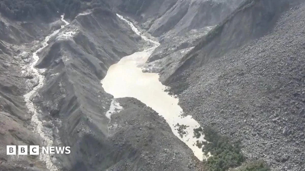
China has issued a grave warning regarding a substantial barrier lake that has formed following a recent devastating landslide near the Nepal-Tibet border, stating there is a "high risk" that the accumulated water may breach its natural banks, potentially triggering a catastrophic second flood downstream. This alarming development follows closely on the heels of a deadly flash flood that occurred in the same geologically volatile region on Wednesday, an event scientists have attributed to the dramatic collapse of a mountain glacier into a river, unleashing a torrent of water and debris. The escalating situation underscores the profound and immediate threats posed by the region’s dynamic geomorphology, exacerbated by climate-induced changes and the inherent challenges of disaster management in remote, high-altitude environments.
As of Friday morning, monitoring efforts by Chinese authorities revealed a staggering accumulation of an estimated 2.5 million cubic metres of water within the newly formed barrier lake. This volume, reported by state broadcaster CCTV, represents a significant and rapidly growing reservoir of potential energy. A barrier lake, by definition, is a body of water impounded by a natural dam, typically formed by a landslide, glacial moraine, or volcanic eruption, which obstructs the flow of a river. In this specific instance, the colossal amount of debris from the recent landslide has effectively created a natural dam across the confluence of the Chhochen Khola and Purepu Tsangpo rivers, leading to the rapid impoundment of water. Officials have further cautioned that an additional three million cubic metres of water is projected to flow into the nascent lake between Thursday and the upcoming weekend, dramatically escalating the "high risk of breach" assessment. This influx is likely a combination of continued meltwater from upstream glaciers and intensified rainfall, a common occurrence in the Himalayan monsoon season.
The immediate implications of this burgeoning hazard are already manifest. China’s Ministry of Water Resources has confirmed that the barrier lake has commenced overflowing, a critical indicator of its instability and the immense pressure it is exerting on its natural containment. The region has also been experiencing heavy rainfall, further contributing to the water volume and potentially weakening the integrity of the natural dam. In response to the escalating threat, authorities have swiftly deployed specialized engineering teams to the site. Their critical mission involves continuous monitoring of the lake’s fluctuating water levels and a meticulous assessment of the prevailing atmospheric conditions, which can significantly influence the rate of water accumulation and the structural stability of the debris dam.
However, the challenging terrain and the very nature of the disaster have severely hampered emergency response efforts. A CCTV report on Friday morning highlighted that the majority of Chinese emergency services personnel were effectively stranded at a village approximately 7 kilometres (4 miles) from Gyirong Port. This vital land crossing, a major artery linking Nepal and China, was itself severely impacted by Wednesday’s initial massive flood. The reason for their immobility was directly attributed to the barrier lake’s "overflowing non-stop," creating conditions that could lead to fresh flash floods or dangerous debris flows at any moment, making further movement upstream perilous. Consequently, all search and rescue operations near the Nepal-Tibet border have been regrettably suspended, prioritizing the safety of responders in the face of this imminent, unpredictable threat.
The Preceding Catastrophe: A Glacier’s Collapse and Its Aftermath
The current crisis is a direct consequence of the catastrophic events that unfolded on Wednesday. Scientists and hydrologists have converged on the explanation that the initial deadly flash flood was triggered by the sudden and monumental collapse of a mountain glacier into a river system. Such events, often referred to as a form of glacial lake outburst flood (GLOF) or a glacier detachment event, are characterized by the rapid release of vast quantities of water and ice, generating immense destructive power as they surge downstream. The sheer scale of the initial event led to widespread destruction, washing away infrastructure and tragically claiming lives, though precise casualty figures from the Nepalese side of the border are still being compiled amidst the ongoing instability.
The collapse of a glacier can occur due to various factors, including internal ice dynamics, seismic activity, or, increasingly, due to rapid melting induced by rising global temperatures, which can destabilize ice masses and surrounding rock. When a large volume of ice and rock plunges into a river or valley, it can create a temporary dam, which then either rapidly breaches, causing a flash flood, or slowly impounds water, forming a barrier lake as seen in the present situation. The Wednesday event appears to have initiated both processes simultaneously – an immediate flash flood followed by the formation of a more stable, albeit precarious, barrier lake upstream.
Chronology of a Developing Crisis
The sequence of events leading to the current high-alert status has unfolded rapidly:
- Wednesday: A massive flash flood strikes the Nepal-Tibet border region. Scientific assessments quickly link the event to the collapse of a mountain glacier into a river. The immediate deluge causes significant damage and casualties. Simultaneously, the enormous volume of debris carried by the floodwaters begins to accumulate, initiating the formation of a natural dam across the Chhochen Khola and Purepu Tsangpo rivers.
- Thursday: Water accumulation behind the newly formed debris dam accelerates throughout the day. Chinese authorities begin to monitor the nascent barrier lake, recognizing its potential threat. Initial projections indicate a rapid increase in water volume.
- Friday Morning: State broadcaster CCTV reports an estimated 2.5 million cubic metres of water has already accumulated in the barrier lake. China’s Ministry of Water Resources confirms that the lake has begun to overflow, a critical sign of rising pressure and potential instability. Engineering teams are dispatched for urgent, on-site monitoring. Emergency services attempting to reach the affected Gyirong Port area are forced to halt 7 km away due to the continuous overflow and the associated risk of fresh floods and debris flows, leading to the suspension of search and rescue operations.
- Late Friday/Weekend Outlook: Officials project an additional 3 million cubic metres of water will flow into the lake, pushing the total volume well beyond 5 million cubic metres. This anticipated influx significantly elevates the "high risk of breach" assessment, prompting intensified vigilance and contingency planning.
Official Responses and Operational Challenges
The response from Chinese authorities has been characterized by rapid assessment and warnings, reflecting the severe nature of the threat. The Ministry of Water Resources, along with local disaster management agencies and the state broadcaster CCTV, have been instrumental in disseminating information and mobilizing resources. The deployment of engineering teams equipped to monitor water levels, dam stability, and atmospheric conditions is crucial for real-time risk assessment. These teams often employ remote sensing technologies, drone surveillance, and ground-based sensors to gather vital data in hazardous environments.
However, the geographical and logistical challenges are immense. The affected area is remote, mountainous, and prone to further instability. The continuous overflow of the barrier lake not only poses a direct threat but also renders access roads impassable, effectively isolating emergency response teams from the most critical areas. The 7 km distance separating emergency services from Gyirong Port, a relatively short distance in normal circumstances, becomes an insurmountable barrier when faced with raging waters and the constant threat of fresh debris flows. This operational impediment directly impacts the ability to conduct search and rescue operations, provide aid, or implement mitigation measures closer to the lake itself. The suspension of search and rescue is a difficult but necessary decision, underscoring the extreme danger posed to human life in the immediate vicinity.
On the Nepalese side, while direct statements were not provided in the original brief, it is highly probable that authorities are on high alert, coordinating with Chinese counterparts, and preparing for potential downstream impacts. Major rivers originating in Tibet and flowing into Nepal, such as the Trishuli River system which would be directly impacted by a breach in this area, traverse densely populated valleys. Warnings would likely be issued to communities in vulnerable areas, and disaster preparedness units would be activated for potential evacuations and response efforts. Cross-border communication and cooperation become paramount in managing transboundary hazards of this scale.
Broader Context: The Himalayan Hazard and Climate Change
The current crisis is not an isolated incident but rather a stark illustration of the increasing geohazards faced by the Himalayan region. This mountain range, the youngest and most seismically active in the world, is inherently unstable, characterized by steep slopes, fragile geological formations, and powerful river systems.
The phenomenon of glacial lake outburst floods (GLOFs) has historically posed a significant threat in the Himalayas. These events occur when glacial lakes, often dammed by unstable moraines (accumulations of glacial debris), suddenly release large volumes of water due to dam failure, an avalanche, or an earthquake. While the current event involves a landslide-dammed lake, the underlying risks and catastrophic potential are eerily similar to GLOFs.
Scientific consensus increasingly points to climate change as a major exacerbating factor. Rising global temperatures are leading to accelerated glacier melt across the Himalayas. This melt contributes to the rapid growth and formation of new glacial lakes, increases the volume of water in existing ones, and can destabilize glaciers themselves, making them more prone to collapse. Furthermore, increased meltwater can saturate slopes, making them more susceptible to landslides, particularly during periods of intense rainfall, which are also projected to become more extreme with climate change. The combination of retreating glaciers, increased meltwater, and potentially more intense precipitation creates a dangerous feedback loop, amplifying the risk of events like the one currently unfolding.
Historical data provides a grim precedent. Numerous GLOFs and landslide-induced floods have devastated communities in Nepal, India, Bhutan, and China over the past decades. For instance, the 2014 Sunkoshi landslide in Nepal, which created a similar barrier lake, caused significant displacement and disrupted the Araniko Highway, another vital trade route. The Kosi River flood in 2008, though different in origin, highlighted the immense transboundary impact of Himalayan river disasters. These events underscore the urgent need for robust early warning systems, cross-border cooperation, and climate change adaptation strategies.
Downstream Impact and Preparedness
Should the barrier lake breach its banks, the downstream consequences would be catastrophic. A sudden release of millions of cubic metres of water would create a powerful flood wave, carrying vast amounts of sediment, boulders, and debris. This "debris flow" would obliterate anything in its path:
- Humanitarian Crisis: Lives would be at immediate risk, potentially leading to significant casualties and widespread displacement of communities living along the riverbanks in both Nepal and Tibet. Access to clean water, food, and shelter would become critical.
- Infrastructure Destruction: Roads, bridges, hydropower projects, and communication networks would be severely damaged or destroyed, hindering rescue and relief efforts and isolating affected areas for prolonged periods. The already damaged Gyirong Port, a critical trade gateway, would face further, potentially irreparable, destruction, impacting regional commerce for months or even years.
- Economic Disruption: The disruption of trade through Gyirong Port, a crucial link in the Nepal-China economic corridor, would have far-reaching economic implications for both nations. Local economies, heavily reliant on agriculture and trade, would suffer immense losses.
- Environmental Degradation: The sheer volume of debris would drastically alter river courses, destroy riparian ecosystems, and impact biodiversity. Agricultural land would be rendered infertile by thick deposits of sand and rock.
Preparedness in such an unpredictable scenario focuses primarily on early warning and evacuation. Given the "high risk" warning, both Chinese and Nepalese authorities would be prioritizing communication with vulnerable downstream communities, identifying safe evacuation routes, and preparing emergency shelters. However, the speed at which such an event can unfold often leaves little time for comprehensive action, highlighting the inherent challenges of managing these natural hazards.
Expert Commentary and Scientific Perspective
Hydrologists and glaciologists emphasize the dynamic and often unpredictable nature of landslide-dammed lakes. Dr. Li Wei, a prominent Chinese glaciologist, might comment, "The stability of a debris dam is highly variable. Factors like the composition of the debris, the rate of water inflow, and seismic activity can all contribute to a sudden failure. The continuous overflow, coupled with ongoing rainfall, is a major red flag as it indicates increasing pressure on the dam and potential erosion."
Similarly, Dr. Kamala Sharma, a Nepalese expert in disaster risk reduction, could stress the cross-border implications: "These events do not respect national boundaries. Effective early warning systems, real-time data sharing between China and Nepal, and coordinated disaster response protocols are absolutely essential to mitigate the humanitarian and economic impact of such transboundary hazards. The lessons from previous GLOFs and landslides must inform our current actions." Their insights underscore the complexity and interconnectedness of the challenges.
Conclusion: A Region on Edge
The Nepal-Tibet border region remains on a knife-edge, grappling with the immediate aftermath of one natural disaster while staring down the barrel of another, potentially even more devastating, event. China’s urgent warning about the high risk of a barrier lake breach serves as a stark reminder of the immense power of nature and the increasing vulnerability of high-mountain regions. The efforts of engineering teams to monitor the lake and the difficult decisions made to suspend search and rescue operations highlight the gravity of the situation and the immense challenges faced by emergency responders. As millions more cubic metres of water are projected to flow into the unstable lake, the coming days will be critical, demanding unwavering vigilance, coordinated international effort, and a continued focus on protecting human lives and livelihoods in the shadow of the world’s highest mountains. The unfolding crisis underscores the imperative for proactive climate adaptation strategies and enhanced regional cooperation to manage the growing specter of Himalayan geohazards.