

Reunion Island, a French overseas department nestled in the Indian Ocean, has been transformed into a geological spectacle as its highly active Piton de la Fournaise volcano continues an effusive eruption that commenced on February 13th. The ongoing event, which marks the volcano’s second eruption this year, reached a dramatic crescendo on Sunday, March 19th, when incandescent lava flows from the volcano finally cascaded into the Indian Ocean. This momentous occasion, witnessed by throngs of captivated tourists and local residents, marked the first time in 19 years that lava from Piton de la Fournaise has reached the sea, creating a mesmerizing, yet potentially hazardous, interaction between extreme heat and cold water. While the visual display has drawn global attention and significantly boosted volcano tourism, the extensive lava flows have also caused considerable disruption, notably severing a critical national highway that links the island’s southern and eastern regions, posing logistical challenges for inhabitants and commerce.
The Spectacle Unfolds: Lava Meets the Ocean
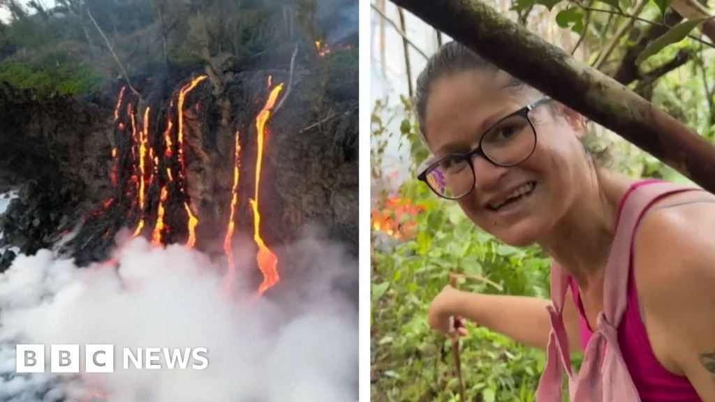
The journey of the molten rock culminated in a breathtaking display as the primary lava front, having slowly traversed the rugged terrain of the Grand Brûlé, reached the coastline in the early hours of Sunday, March 19th. The precise point of entry was near the area known as Pointe du Tremblet, within the Saint-Philippe commune, a zone frequently impacted by previous eruptions. As the lava, estimated to be around 1,000 to 1,200 degrees Celsius, met the comparatively frigid ocean waters, plumes of white steam, laden with hydrochloric acid and fine glass particles (known as "laze" – lava haze), billowed skyward. This phenomenon, while visually stunning, necessitates strict safety protocols due to its corrosive and irritating nature, posing risks to respiratory systems and eyes.
Hundreds of onlookers, adhering to safety perimeters established by local authorities, gathered at vantage points to witness this rare geological event. The vibrant orange and red hues of the flowing lava contrasted sharply with the deep blue of the ocean and the white steam clouds, creating an unforgettable panorama, particularly striking under the cover of night. Scientists and observers noted the rapid creation of new land as the lava solidified upon contact with seawater, a testament to the Earth’s dynamic processes continually reshaping its surface. The last time Piton de la Fournaise’s lava reached the ocean was in April 2004, an event that similarly drew widespread attention and scientific interest.
A History of Activity: Piton de la Fournaise’s Volcanic Pedigree
Piton de la Fournaise, meaning "Peak of the Furnace," is one of the world’s most active shield volcanoes, ranking alongside Kīlauea in Hawaii and Etna in Italy for its frequent eruptions. Located in the southeastern part of Reunion Island, it is a basaltic volcano characterized by effusive eruptions, where lava flows relatively gently rather than explosively. This type of activity is generally less hazardous than explosive eruptions, but the sheer volume and reach of lava flows can still be highly destructive to infrastructure and vegetation.
The volcano is part of the Piton de la Fournaise massif, which is itself a remnant of a larger volcanic edifice that formed the island over millions of years. It rises to an altitude of 2,632 meters (8,635 feet) and is dominated by a large caldera, the Enclos Fouqué, within which most eruptions occur. Its consistent activity makes it an invaluable natural laboratory for volcanologists, providing continuous opportunities to study eruption mechanisms, lava flow dynamics, and the interaction between magma and the environment. The island’s entire landscape, a UNESCO World Heritage site, bears the indelible marks of this geological power, from its dramatic peaks and calderas to its fertile volcanic soils.
Chronology of the Current Eruption: From Tremors to Ocean Entry
The current eruptive sequence of Piton de la Fournaise commenced on February 13th, marking its second outbreak in 2023, following a brief eruption earlier in January. This latest activity was preceded by a period of increased seismic activity and ground deformation, indicators closely monitored by the Observatoire Volcanologique du Piton de la Fournaise (OVPF).
- Early February: Increased seismicity beneath the summit region, accompanied by inflation of the volcano’s edifice, signaling magma migration towards the surface.
- February 13th, 08:30 local time: The eruption began, initially characterized by fissure openings within the Enclos Fouqué, specifically on the southern flank of the volcano, near the crater Dolomieu. Several lava fountains erupted, quickly forming distinct lava flows.
- February 13th – March 1st: Lava flows primarily remained within the Enclos Fouqué, gradually expanding. Initial flow rates were significant, but the lava front progressed slowly through the rugged, pre-existing lava fields.
- Early March: A particularly vigorous lava flow emerged from one of the fissures, developing a robust lava tube system. This system allowed the lava to travel long distances without significant cooling, maintaining its fluidity.
- March 10th-15th: The main lava flow, fed by the efficient lava tube, exited the Enclos Fouqué through a breach in the caldera wall, beginning its descent towards the eastern coast. Its path followed pre-existing valleys and channels carved by previous eruptions.
- March 17th: The lava flow reached the vicinity of the national highway RN2, leading to its immediate closure and triggering emergency response protocols.
- March 19th, pre-dawn: After weeks of relentless flow, the primary lava front finally reached the Indian Ocean, marking the first ocean entry event since 2004. This moment was extensively documented by scientists and media alike.
- Post-March 19th: The eruption continues, albeit with fluctuating intensity. Multiple active vents feed the main lava flow, and the interaction with the ocean persists, leading to continued new land formation and associated atmospheric phenomena.
Scientific Monitoring and Data: The Eye on the Furnace
The monitoring of Piton de la Fournaise is primarily conducted by the Observatoire Volcanologique du Piton de la Fournaise (OVPF), a branch of the Institut de Physique du Globe de Paris (IPGP). The OVPF maintains a comprehensive network of sensors across the volcano, providing real-time data crucial for understanding its behavior and issuing warnings.
This network includes:
- Seismometers: To detect earthquakes and tremors, indicating magma movement.
- GPS stations and tiltmeters: To measure ground deformation, showing inflation or deflation of the volcano.
- Gas sensors: To monitor the release of volcanic gases (SO2, CO2, H2S), which can signal changes in magmatic activity.
- Thermal cameras and drones: To observe lava flow progression, temperature, and vent activity, especially during eruptions.
During the current eruption, OVPF data revealed significant magma intrusion prior to the February 13th onset. Lava discharge rates were initially estimated at several cubic meters per second, gradually varying over the eruption’s course. The efficiency of the lava tube system was a key factor in the lava’s long-distance travel, protecting the molten rock from rapid cooling and allowing it to reach the ocean. Scientists continuously analyze the chemical composition of the erupted basaltic lava, which provides insights into the magma’s source and evolution within the volcano’s plumbing system. The OVPF’s diligent work ensures that authorities and the public are kept informed, enabling timely safety measures and scientific understanding of this dynamic natural wonder.
Infrastructure and Daily Life Impact: The Price of Proximity
While the eruption offers a captivating natural spectacle, its practical implications for the inhabitants of Reunion Island are considerable. The most significant disruption has been the severing of the Route Nationale 2 (RN2), the vital coastal highway connecting the island’s more populous west and north with the eastern and southern regions. Two distinct lava flows from the Piton de la Fournaise eruption have directly crossed the highway, rendering sections impassable and necessitating its immediate closure.
The RN2 is not merely a scenic route; it is a primary artery for daily commutes, commercial transport, and tourism. Its closure has forced residents and businesses to rely on alternative, often longer and more circuitous, inland routes. This has led to increased travel times, higher fuel consumption, and significant logistical challenges for the transport of goods and services. For instance, agricultural products from the eastern plains, or goods arriving at the main port in Le Port, now face extended transit times to reach markets or consumers in the affected southern and eastern areas. Local businesses, particularly those reliant on direct road access or tourist traffic along the coast, have reported varying degrees of impact, from minor delays to more substantial operational adjustments. The cost of repairing or rerouting the highway, once the eruption subsides and the lava cools sufficiently, is anticipated to be substantial, adding another layer of economic burden.
Official Response and Safety Measures: Balancing Access and Protection
In response to the eruption and its potential hazards, the Prefecture of Reunion Island, the highest state authority on the island, has implemented a robust set of safety protocols and public advisories. The primary objective is to ensure public safety while allowing managed access for observation where feasible.
Key measures include:
- Restricted Access Zones: A strict security perimeter has been established around the eruption site and the lava flow fronts, particularly where the lava meets the ocean. Access to these high-risk areas is strictly forbidden to unauthorized personnel due to the dangers of hot lava, collapsing cliffs, toxic gases, and unstable ground.
- Road Closures: The RN2 and other affected local roads were immediately closed upon the lava flows’ approach, with diversions put in place.
- Public Information Campaigns: The Prefecture, in collaboration with the OVPF, regularly issues press releases and updates through local media, informing the public about the eruption’s status, safety guidelines, and road conditions.
- Emergency Services Deployment: Gendarmerie and civil security units have been deployed to enforce safety perimeters, manage traffic, and respond to any potential incidents.
- Scientific Monitoring: The OVPF provides continuous scientific analysis and alerts, which directly inform the Prefecture’s decision-making regarding public safety.
Officials have repeatedly urged both locals and visitors to exercise extreme caution, respect all safety instructions, and avoid venturing into prohibited areas. The allure of witnessing such a powerful natural event is strong, but the risks associated with active lava flows and their interaction with the environment are significant and potentially life-threatening.
Environmental and Geological Ramifications: New Land, New Challenges
The interaction of molten lava with seawater creates a complex set of environmental and geological effects that extend beyond the immediate spectacle.
- New Land Formation: As the lava solidifies upon contact with the ocean, it creates new land, gradually extending Reunion Island’s coastline. While this process is fundamental to the formation of volcanic islands, it can alter local marine habitats and coastal dynamics.
- Laze Plumes: The "laze" (lava haze) produced when lava meets seawater is a significant environmental concern. It consists of a corrosive mixture of hydrochloric acid vapor, steam, and tiny shards of volcanic glass. This plume can drift downwind, causing respiratory irritation, skin burns, and eye irritation for anyone exposed. It also poses a threat to vegetation and infrastructure in its path.
- Thermal Shock to Marine Life: The sudden influx of extremely hot lava into the ocean causes a localized thermal shock, leading to the rapid heating and acidification of seawater. This can kill marine organisms in the immediate vicinity, including fish, corals, and other invertebrates. However, such impacts are typically localized, and marine ecosystems often demonstrate resilience over time.
- Ash and Gas Emissions: While basaltic eruptions are generally less explosive, they still release volcanic gases (sulfur dioxide, carbon dioxide) and fine ash particles. These can affect air quality locally and have broader, though usually temporary, atmospheric impacts.
Geologically, the creation of new land is a fundamental process, but the newly formed coastal areas are often unstable, prone to collapses, and extremely hot for extended periods, making them hazardous.
Tourism and Economic Dynamics: A Double-Edged Sword
The eruption of Piton de la Fournaise presents a unique duality for Reunion Island’s economy, particularly its tourism sector. On one hand, the spectacle of an active volcano, especially one whose lava flows reach the ocean, is an unparalleled draw for tourists worldwide.
- Increased Visitor Numbers: Tour operators and local businesses in areas accessible to viewing points have reported a significant surge in interest and bookings. Many visitors specifically travel to Reunion Island to witness this rare phenomenon, providing a substantial boost to hotels, restaurants, and guided tour services.
- Global Media Attention: The eruption has garnered international media coverage, raising Reunion Island’s profile as a destination for adventure tourism and unique natural experiences. This "free advertising" can have long-term benefits for the island’s tourism brand.
On the other hand, the disruption caused by the lava flows poses challenges:
- Accessibility Issues: The closure of the RN2 impacts tourist travel plans, potentially deterring visitors who rely on easy island-wide circulation. This can negatively affect businesses in regions cut off by the lava.
- Safety Concerns: While managed viewing is possible, persistent safety warnings and the inherent risks of volcanic activity might deter some potential tourists, particularly those traveling with families.
- Impact on Local Commerce: Beyond tourism, the disruption to supply chains and daily commutes can strain local businesses and residents, affecting the overall economic equilibrium.
Local authorities and tourism agencies are actively working to balance these dynamics, promoting safe viewing opportunities while ensuring the safety and well-being of residents and visitors, and providing clear information about accessibility and alternative routes.
Looking Ahead: Continued Vigilance and Adaptation
As the eruption of Piton de la Fournaise continues, the OVPF and local authorities maintain a high level of vigilance. While the intensity of the eruption can fluctuate, the potential for continued lava flows, further ocean entry events, and additional infrastructure impacts remains. Scientists will continue to monitor the volcano’s internal plumbing system for signs of changes in magma supply or eruptive style. For the residents of Reunion Island, living alongside one of the world’s most active volcanoes is a perpetual dance between awe and adaptation. The current eruption stands as a powerful reminder of the island’s dynamic geological heritage and the constant interplay between nature’s raw power and human resilience.