

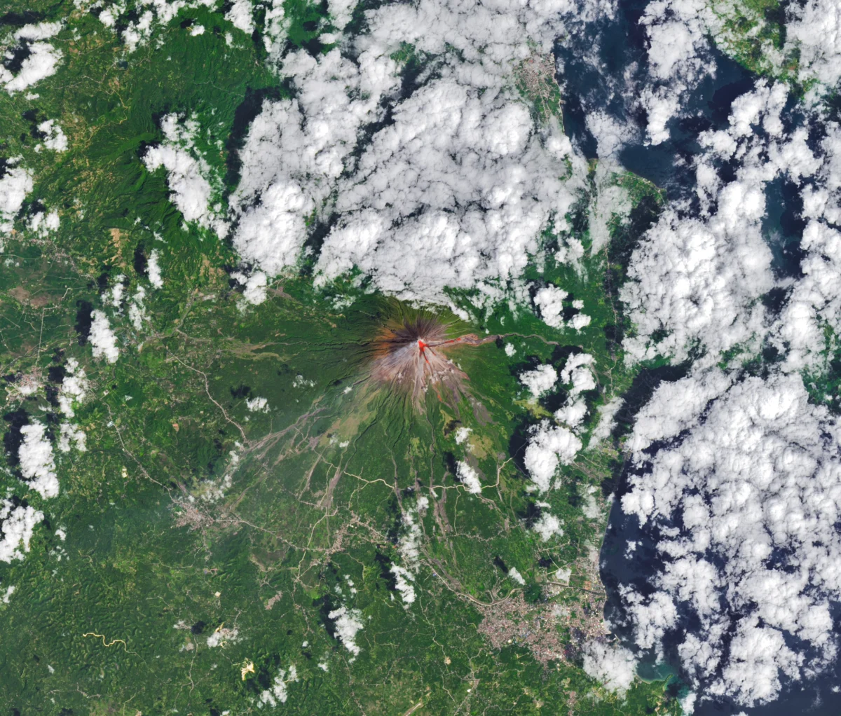
The Operational Land Imager (OLI) aboard Landsat 8, a cornerstone of NASA’s Earth-observing satellite fleet, successfully acquired a rare, relatively clear image of Mayon Volcano, the Philippines’ most active stratovolcano, on February 26, 2026. This natural-color scene, enhanced with infrared observations to vividly highlight the volcano’s heat signature, provided critical data to scientists and disaster management agencies monitoring the escalating unrest. On the day the image was captured, the Philippine Institute of Volcanology and Seismology (PHIVOLCS) reported a significant surge in volcanic activity, including numerous volcanic earthquakes, frequent rockfalls, and the ominous presence of hot clouds of ash and debris, known as pyroclastic flows, descending the volcano’s slopes. Concurrently, multiple NASA satellites have been diligently tracking Mayon’s sulfur dioxide (SO2) emissions, recording sizable plumes drifting southwestward on February 4 and again on March 6, signaling persistent magmatic activity beneath the iconic peak.
The Eye in the Sky: Landsat 8’s Vital Role in Disaster Monitoring
Landsat 8, launched in 2013 as part of the longest-running Earth-observing satellite program, plays an indispensable role in monitoring changes to Earth’s land surface, including dynamic geological events like volcanic eruptions. Its Operational Land Imager (OLI) instrument is designed to collect high-resolution imagery across multiple spectral bands, offering unparalleled detail of terrestrial features. The February 26, 2026, image of Mayon was particularly valuable due to its relative clarity, a significant challenge given the frequent cloud cover often associated with tropical regions and volcanic emissions. By overlaying infrared data onto the natural-color scene, scientists were able to precisely delineate areas of elevated temperature, indicative of lava flows or superheated rock, providing a direct visual confirmation of the intense thermal activity reported by ground-based observers. This capability allows for the remote detection and mapping of active lava flows, hot spots, and thermal anomalies, which are crucial for assessing the immediate hazards and understanding the dynamics of an ongoing eruption. The data collected by Landsat 8 complements ground observations, offering a broader spatial context and enabling monitoring of remote or inaccessible areas, thereby enhancing the overall understanding of Mayon’s behavior during this period of heightened unrest.
A Chronology of Unrest: Mayon’s February-March 2026 Activity
The escalating activity at Mayon Volcano in early 2026 did not manifest suddenly but rather as a series of intensifying events, meticulously tracked by both local and international monitoring bodies. The first significant indicator of heightened magmatic unrest in this specific timeframe emerged on February 4, 2026, when NASA satellites detected a substantial plume of sulfur dioxide (SO2) drifting southwest. Elevated SO2 emissions are a critical precursor and indicator of magma degassing at shallow depths, often preceding or accompanying eruptive phases. This initial detection served as an early warning, prompting increased vigilance from PHIVOLCS and local disaster response units.
The situation culminated on February 26, the day Landsat 8 captured its revealing image. PHIVOLCS detailed a significant increase in seismic activity, characterized by a rise in volcanic earthquakes, which signify magma and gas movement beneath the edifice. Accompanying these seismic events were frequent rockfalls, indicating the instability of the volcano’s upper slopes, likely due to pressure changes or the extrusion of viscous lava. Most concerning, however, was the observation of pyroclastic flows. These fast-moving currents of superheated gas, ash, and volcanic debris are among the most destructive volcanic hazards, capable of obliterating everything in their path and traveling at speeds exceeding hundreds of kilometers per hour. Their presence underscored the extreme danger within the volcano’s declared danger zones.
Following this peak activity, satellite monitoring continued to be crucial. On March 6, 2026, another sizable SO2 plume was detected by NASA satellites, confirming that the magmatic system remained active and continued to release significant amounts of volcanic gases. This sustained emission pattern indicated that while the intensity of surface activity might fluctuate, the underlying geological processes driving the eruption were ongoing, necessitating continued high alert. The combined data from ground observations and satellite imagery provided a comprehensive, multi-layered picture of Mayon’s dynamic and dangerous state throughout this critical period.
Understanding Mayon: The Philippines’ Most Active Volcano
Mayon Volcano, situated in the province of Albay on the island of Luzon, Philippines, is renowned globally for its near-perfect symmetrical cone, a geological marvel that has captivated observers for centuries. However, its aesthetic beauty belies its formidable power and status as the most active volcano in the Philippines. Classified as a stratovolcano (or composite volcano), Mayon is characterized by its steep profile and periodic explosive eruptions, built up over thousands of years by layers of hardened lava, tephra, pumice, and volcanic ash. Its location within the Pacific Ring of Fire, a region notorious for frequent earthquakes and volcanic eruptions, places it in a highly tectonically active zone where the Philippine Sea Plate subducts beneath the Eurasian Plate.
With a documented history spanning over 400 years, Mayon has erupted more than 50 times, often with devastating consequences. Notable past eruptions include the catastrophic event of February 1, 1814, which buried the town of Cagsawa and killed over 1,200 people, leaving behind only the iconic Cagsawa belfry as a grim reminder. More recently, eruptions in 1993, 2006, 2009, 2014, and 2018 have forced large-scale evacuations and caused significant disruption. The 2018 eruption, for instance, saw explosive activity, lava flows, and pyroclastic density currents that displaced tens of thousands of residents.
The hazards associated with Mayon are multifaceted. Beyond the pyroclastic flows observed on February 26, the volcano is prone to effusive lava flows, which, while slower, can still engulf communities and agricultural lands. Ashfall, composed of fine volcanic glass and rock fragments, can blanket vast areas, damaging crops, contaminating water sources, and posing respiratory health risks. Lahars, destructive mudflows composed of volcanic debris and water, often triggered by heavy rainfall interacting with fresh ash deposits, represent another severe threat, particularly during typhoon seasons. The constant threat posed by Mayon necessitates robust and continuous monitoring, coupled with proactive community preparedness and rapid response mechanisms.
The Guardians on the Ground: PHIVOLCS’ Monitoring and Response
The Philippine Institute of Volcanology and Seismology (PHIVOLCS) serves as the primary scientific and technical agency responsible for monitoring volcanic activity, earthquakes, and tsunamis in the Philippines. Its mandate includes providing timely and accurate information to the public and disaster management authorities to minimize the impact of these natural hazards. At Mayon, PHIVOLCS maintains a sophisticated network of monitoring instruments, including seismic sensors to detect volcanic earthquakes, GPS receivers and tiltmeters to measure ground deformation (indicating magma movement), gas analyzers to track sulfur dioxide and other volcanic gas emissions, and thermal cameras to monitor surface temperatures.
Upon the detection of increasing unrest, as observed in early 2026, PHIVOLCS activated its comprehensive alert level system, ranging from Level 0 (no alert) to Level 5 (hazardous eruption in progress). The reports of volcanic earthquakes, rockfalls, and pyroclastic flows on February 26 would typically correspond to an alert level of 3 or 4, signifying an "eruption in progress" or "hazardous eruption imminent." At such levels, strict enforcement of the Permanent Danger Zone (PDZ) around the volcano, typically a 6-kilometer radius, is implemented, and local authorities are advised to extend evacuation orders to areas beyond the PDZ that are at risk from specific hazards like pyroclastic flows or lahars.

Officials from PHIVOLCS, including its director and lead volcanologists, consistently provided public advisories and scientific explanations, emphasizing the importance of adhering to safety protocols and evacuation orders issued by local government units. Their statements would underscore the unpredictable nature of volcanic eruptions and the critical need for vigilance. PHIVOLCS’ detailed bulletins, disseminated through various media channels, are crucial for informing residents, guiding local government actions, and coordinating emergency responses, ensuring that communities are prepared for potential further escalation.
Global Vigilance: NASA’s Satellite Monitoring of Sulfur Dioxide
Beyond the visible imagery provided by Landsat 8, NASA’s broader satellite infrastructure offers crucial insights into Mayon’s subterranean activity through the monitoring of volcanic gas emissions, particularly sulfur dioxide (SO2). SO2 is a key indicator of magmatic processes, as it is released when magma rises closer to the surface and degasses. Significant increases in SO2 flux can signal increased magma supply, potentially leading to more intense or prolonged eruptions.
NASA utilizes a suite of instruments on various satellites, such as the Ozone Monitoring Instrument (OMI) on the Aura satellite and the Tropospheric Monitoring Instrument (TROPOMI) on the Sentinel-5P satellite, to detect and quantify SO2 plumes. These instruments measure the absorption of ultraviolet (UV) radiation by SO2 in the atmosphere, allowing scientists to track the movement and concentration of volcanic gas emissions globally. The detection of sizable SO2 plumes drifting southwest on February 4 and March 6, 2026, was highly significant. These observations provided independent confirmation of sustained magmatic activity, reinforcing PHIVOLCS’ ground-based assessments and offering a valuable broader perspective on the eruption’s scale and evolution.
The collaboration between international space agencies like NASA and national geological survey organizations like PHIVOLCS is fundamental to effective disaster risk reduction. Satellite data provides a global context and fills gaps where ground-based monitoring might be limited due to remoteness, hazardous conditions, or resource constraints. This integrated approach, combining remote sensing with on-the-ground expertise, enhances the accuracy of eruption forecasts, improves the timeliness of warnings, and ultimately aids in protecting lives and livelihoods.
Implications and Impact: A Multifaceted Challenge
The heightened activity at Mayon Volcano, as captured by Landsat 8 and monitored by various agencies, carries profound and multifaceted implications across humanitarian, environmental, economic, and scientific domains.
Humanitarian and Social Impact: The most immediate concern during an eruption is the safety and displacement of the population. The strict enforcement of danger zones and mandatory evacuations lead to thousands of residents being temporarily or, in some cases, permanently displaced from their homes and livelihoods. This displacement creates significant challenges, including providing adequate shelter, food, water, and sanitation for evacuees. The constant threat of eruption also takes a heavy psychological toll on affected communities, fostering anxiety and uncertainty. Respiratory illnesses due to ashfall and volcanic gases are also a significant health concern, particularly for vulnerable populations. The disruption of education for children in affected areas further exacerbates social challenges.
Environmental and Agricultural Impact: Mayon’s eruptions have a devastating impact on the local environment and agriculture, which is a cornerstone of the Bicol region’s economy. Ashfall can blanket vast areas, destroying crops, contaminating water sources, and rendering agricultural land temporarily unusable. Livestock can also be affected by consuming ash-covered forage or contaminated water. Lava flows and pyroclastic flows permanently alter the landscape, burying forests, rivers, and cultivated fields. The long-term environmental consequences can include changes in soil composition, water quality degradation, and ecosystem disruption, requiring extensive rehabilitation efforts.
Economic Repercussions: The economic costs associated with Mayon’s eruptions are substantial. Agricultural losses, particularly of staple crops like rice and corn, and cash crops like abaca, can cripple local economies. The tourism industry, which heavily relies on Mayon’s iconic beauty, experiences a sharp decline during periods of unrest. Infrastructure damage, including roads, bridges, and utilities, necessitates costly repairs and reconstruction. Government resources are heavily diverted towards relief operations, evacuation management, and rehabilitation programs, impacting other developmental initiatives. Local businesses suffer from reduced consumer activity and supply chain disruptions.
Scientific Advancements and Global Collaboration: Despite the destructive nature of eruptions, they also present invaluable opportunities for scientific research. The comprehensive data collected by ground-based instruments and satellite missions like Landsat 8 and NASA’s SO2 trackers contribute significantly to the global understanding of volcanic processes. This data allows volcanologists to refine predictive models, improve hazard mapping, and develop more effective early warning systems. The event also underscores the critical importance of international scientific collaboration and data sharing in addressing global natural hazards, fostering a collective effort to mitigate risks and enhance resilience worldwide.
Looking Ahead: Preparedness and Resilience
As Mayon Volcano continues its dynamic cycle of activity, the imperative for sustained vigilance, robust preparedness, and community resilience remains paramount. The detailed imagery from Landsat 8, combined with PHIVOLCS’ ground-based monitoring and NASA’s atmospheric observations, provides an invaluable toolkit for understanding the volcano’s behavior and mitigating its potential impacts. Efforts to educate local populations about volcanic hazards, conduct regular evacuation drills, and maintain well-equipped disaster response units are crucial. The ongoing scientific study of Mayon will undoubtedly lead to further refinements in eruption forecasting and hazard assessment, enhancing the ability of authorities to protect the communities living in the shadow of this magnificent yet dangerous natural wonder. The events of February and March 2026 serve as a stark reminder of Earth’s powerful geological forces and the continuous need for human ingenuity and cooperation in the face of natural challenges.