


Kīlauea, one of the world’s most active and continuously monitored volcanoes, marked its 43rd eruptive episode since its reawakening in December 2024 with a dramatic display of high lava fountains and extensive ash dispersal on March 10, 2026. This latest surge in activity, centered within the Halemaʻumaʻu Crater at the volcano’s summit, saw lava fountains reach an estimated 1,770 feet (540 meters), setting a new record for the current eruptive cycle. The event prompted significant public safety alerts, aviation disruptions, and temporary closures across Hawaiʻi Island, underscoring the dynamic and ever-present geological forces shaping the archipelago.
A Fiery Reawakening: Kīlauea’s Persistent Activity
Kīlauea’s current phase of episodic activity began in December 2024, following a period of relative quiescence. This reawakening initiated a new chapter in the volcano’s long history of eruptions, characterized by dozens of distinct lava fountaining events, each varying in intensity and duration from several hours to several days. This pattern of intermittent yet powerful eruptions has been a hallmark of Kīlauea’s behavior for decades, even centuries, constantly reshaping its summit caldera and the surrounding landscape. The volcano, located within Hawaiʻi Volcanoes National Park, has been under continuous observation by the Hawaiian Volcano Observatory (HVO) of the U.S. Geological Survey (USGS), providing invaluable data on its complex processes.
The ongoing activity represents a significant refilling of the Halemaʻumaʻu Crater, which underwent a dramatic collapse during the devastating 2018 eruption that saw lava inundate communities on Kīlauea’s Lower East Rift Zone. Since December 2024, the cumulative volume of erupted lava has reached close to 325 million cubic yards (250 million cubic meters), causing the depth of lava in the crater to increase by approximately 300 feet (90 meters). This steady accumulation of fresh basaltic rock within the caldera is a testament to the immense magmatic pressure beneath the volcano.
Episode 43: Record-Breaking Fountains and Widespread Fallout
The latest major flare-up, designated Episode 43, commenced around 9 a.m. local time on March 10, 2026, with lava erupting vigorously from two active vents situated on the southwest side of Halemaʻumaʻu Crater. For approximately nine hours, until 6 p.m. local time, incandescent streams of molten rock soared skyward, creating spectacular, albeit hazardous, displays. The peak fountain heights, estimated at 1,770 feet (540 meters), not only captivated observers from a safe distance but also served as a potent reminder of Kīlauea’s raw power. These fountains represent the highest recorded in the current eruptive sequence, surpassing previous episodes and contributing a substantial volume of material to the crater floor.
During this single episode, an estimated 16 million cubic yards (12 million cubic meters) of lava were erupted. While the lava flows remained confined to the summit caldera, a crucial aspect of this eruption was the extensive dispersal of ash and other airborne debris, known as tephra. Volcanic gases, primarily sulfur dioxide, accompanied the ash, forming a robust plume that rose to significant altitudes. Satellite imagery captured during daylight hours showed this volcanic plume drifting northeast from the vents, reaching a maximum height of over 30,000 feet (9,100 meters) above sea level, as reported by the HVO.
Tracking the Eruption: Satellite Monitoring and Ground Observations
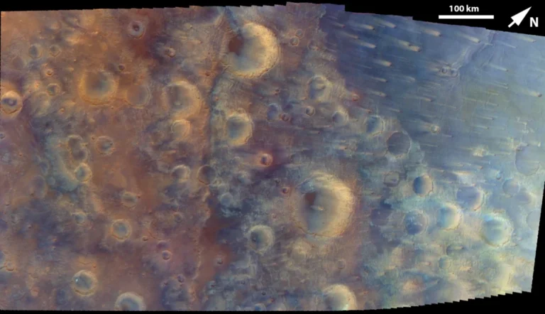
The monitoring of Kīlauea’s dynamic behavior relies on a sophisticated network of ground-based sensors and advanced satellite technology. Approximately four hours after the fountaining subsided, at 10:20 p.m. local time on March 10 (08:20 Universal Time on March 11), the Landsat 9 satellite passed over the Island of Hawaiʻi. This Earth-observing satellite, equipped with the Operational Land Imager (OLI), acquired shortwave infrared and near-infrared data. These spectral bands are particularly effective at detecting heat signatures, revealing the still-sizzling lava within the crater even hours after the most intense fountaining had ceased. This thermal data, layered over a composite of daytime Landsat images and a digital elevation model, provides scientists with critical insights into the distribution and cooling rates of fresh lava.
The Hawaiian Volcano Observatory maintains a comprehensive network of seismometers, GPS receivers, tiltmeters, and gas sensors that continuously track Kīlauea’s every tremor, deformation, and emission. This multi-faceted approach allows HVO scientists to monitor the magma chamber’s inflation and deflation, predict potential eruptive phases, and assess immediate hazards. The combination of ground-based observations with remote sensing from satellites like Landsat 9 offers an unparalleled view into the complex subsurface processes driving Kīlauea’s eruptions, enabling timely warnings and public advisories.
Volcanic Hazards: Ash, Tephra, and Public Safety
The widespread dispersal of ash and tephra posed significant hazards to communities and infrastructure across Hawaiʻi Island. The HVO elevated the aviation color code to red during the eruption, signifying a major volcanic eruption with significant emission of ash into the atmosphere. This immediate alert is crucial for air traffic control, as volcanic ash can severely damage aircraft engines, posing a direct threat to aviation safety. Consequently, several flights at Hilo’s airport were canceled, causing disruptions for travelers and freight.
Volcanic fragments, some measuring several inches in diameter, fell along the north rim of the caldera and in adjacent communities. These larger ballistic fragments, while typically localized, represent a direct physical hazard. Farther afield, smaller particles were carried by prevailing winds, reaching communities tens of miles to the north and east of Kīlauea. Residents in Hilo, Keaʻau, and other coastal areas reported significant fallout of fine ash and Pele’s hair. Pele’s hair, a fascinating and delicate volcanic glass fiber, forms when gas bubbles burst at the surface of lava, stretching molten glass into thin, hair-like strands. While beautiful, both ash and Pele’s hair are abrasive and irritating to the eyes, skin, and respiratory system. The HVO issued warnings advising residents to take precautions, such as staying indoors, wearing masks, and protecting water catchment systems.
Impact on Infrastructure and Daily Life
The direct consequences of Episode 43 were felt across various sectors of Hawaiʻi Island life. The accumulation of volcanic debris on roadways necessitated the temporary closure of Highway 11, a vital artery for transportation on the island. Such closures disrupt daily commutes, commerce, and access for emergency services, highlighting the vulnerability of infrastructure to natural phenomena.
Hawaiʻi Volcanoes National Park, a major tourist attraction and home to Kīlauea’s summit, also implemented temporary closures and visitor evacuations from specific areas. The park’s primary mission includes ensuring visitor safety while providing access to the unique volcanic landscape. During active eruptions, areas prone to ashfall, toxic gas exposure, or potential ballistic hazards are immediately restricted, affecting thousands of visitors who come to witness the volcano’s grandeur.
Beyond the immediate physical hazards, the HVO specifically warned about the potential impact on water quality for residents relying on rainwater catchment systems. Volcanic ash and gases can contaminate collected rainwater, making it unsuitable for drinking without proper filtration and treatment. This poses a significant challenge for many rural communities on Hawaiʻi Island, where such systems are common. The economic implications also extend to local businesses, particularly those in tourism and aviation, experiencing direct revenue losses due to cancellations and reduced visitor numbers.
The Hawaiian Volcano Observatory’s Crucial Role
The Hawaiian Volcano Observatory, established in 1912, plays an indispensable role in monitoring Kīlauea and other Hawaiian volcanoes. Its team of geologists, geophysicists, and other scientists provides continuous surveillance, interprets complex data, and disseminates timely information to the public and authorities. During Episode 43, HVO scientists were instrumental in:
- Real-time Monitoring: Tracking fountain heights, plume dynamics, and seismic activity.
- Hazard Assessment: Determining the extent of ash and tephra fallout, advising on public safety measures.
- Communication: Issuing Volcanic Activity Notices (VANs), updating aviation color codes, and collaborating with civil defense and national park officials.
- Data Collection: Documenting the eruption’s characteristics for long-term scientific understanding of Kīlauea’s behavior.
Their warnings regarding respiratory irritants and water quality contamination are critical for local residents, empowering them to take necessary protective actions.
Kīlauea’s Geological History and Cultural Significance
Kīlauea is not merely a geological feature; it is deeply interwoven with Hawaiian culture and identity. In Hawaiian mythology, Pele, the goddess of fire, lightning, wind, and volcanoes, resides in Halemaʻumaʻu crater. Eruptions are often seen as manifestations of her power and presence. This cultural significance underscores the profound respect and reverence Hawaiians hold for the volcano, even amidst its destructive potential.
Geologically, Kīlauea is a shield volcano, characterized by its broad, gently sloping profile formed by highly fluid basaltic lava flows. It is a younger, more active neighbor to the massive Mauna Loa volcano, and its activity is largely driven by a persistent hotspot beneath the Pacific Plate. Kīlauea has been in an almost continuous state of eruption for much of the past few centuries, with notable periods of intense activity, including the long-running Puʻu ʻŌʻō eruption from 1983 to 2018, and the dramatic summit collapse and Lower East Rift Zone eruption of 2018. The current episodic activity, therefore, fits within a broader pattern of Kīlauea’s dynamic evolution, continually adding new land and reshaping the island.
Environmental and Socio-Economic Implications
The environmental impact of such an eruption is multifaceted. The ashfall can smother vegetation, impacting local ecosystems and agricultural lands. Volcanic gases, particularly sulfur dioxide (SO2), contribute to vog (volcanic smog) downwind, which can degrade air quality, reduce visibility, and cause respiratory problems for sensitive individuals. While new lava flows create fresh land, they also destroy existing habitats and infrastructure.
Socio-economically, the recurring nature of Kīlauea’s eruptions presents a unique set of challenges and adaptations for Hawaiʻi Island residents. The tourism industry, a cornerstone of the island’s economy, is heavily influenced by volcanic activity. While eruptions can draw "volcano tourists" eager to witness the spectacle, widespread ash or road closures can deter general visitors, impacting hotels, tour operators, and related businesses. Local communities have, over generations, developed a resilience and understanding of living alongside an active volcano, adapting building practices, emergency preparedness, and cultural practices to its rhythms.
Looking Ahead: Continuous Vigilance and Adaptation
As Kīlauea enters its second year of episodic activity, the Hawaiian Volcano Observatory emphasizes the importance of continuous vigilance. While Episode 43 saw a temporary peak in intensity, Kīlauea’s behavior is inherently unpredictable. Scientists continue to monitor ground deformation, gas emissions, and seismic activity for clues about future eruptive phases. The data gathered from each episode, including the record-breaking fountains of March 10, 2026, contributes to a more comprehensive understanding of the volcano’s plumbing system and eruption mechanisms.
For the residents of Hawaiʻi Island, living with Kīlauea means a constant state of preparedness and adaptation. The beauty and destructive power of the volcano are an integral part of their home. Through robust scientific monitoring, effective public communication, and community resilience, the island continues to navigate its extraordinary relationship with one of the Earth’s most captivating natural wonders.