




On July 16, 2026, vast plumes of smoke originating from intensified Canadian wildfires continued their eastward and southward trajectory, blanketing significant portions of Ontario and Quebec in Canada, while extending their reach deep into the U.S. Midwest and Northeast. This pervasive smoke has become a recurring and increasingly challenging feature of North American summers, transforming skylines into hazy canvases of grey and yellow, and casting an eerie orange glow over the sun in numerous affected regions. The incident underscores the growing volatility of wildfire seasons across Canada, marking a period of significant activity following what had initially been a comparatively subdued start to the 2026 fire season.
Escalating Wildfire Activity in Canada
After an uncharacteristically slow beginning, Canada’s 2026 wildfire season experienced a dramatic surge in activity towards the end of June. This escalation was primarily driven by a confluence of dry conditions and unseasonably warm temperatures that swept across many parts of the country. By mid-July, the Canadian Interagency Forest Fire Centre (CIFFC), the national coordinating body for wildfire management, reported an alarming 850 active fires burning nationwide. This figure brought the season’s intensity closer to the 25-year average, signaling a significant shift from the earlier, quieter period.
Among the provinces grappling with the most severe outbreaks, Ontario stood out, accounting for more than 180 of the active blazes. These fires, predominantly concentrated in the northwestern reaches of the province, generated immense smoke columns that subsequently dispersed across the continent. The sheer scale of these incidents has necessitated a robust and coordinated response from federal and provincial authorities, involving thousands of firefighters, support personnel, and aerial resources from across Canada and, increasingly, international partners. The CIFFC’s role in facilitating resource sharing and providing crucial data analysis has been central to managing this evolving crisis.
A Season’s Trajectory: From Slow Start to Intensification
The 2026 wildfire season began with an air of cautious optimism, as early spring conditions did not immediately portend the intensity seen in recent extreme years. Public Safety Canada, the federal department responsible for emergency management, had even issued updates in early June noting the relatively low fire activity. However, this respite proved short-lived. By the third week of June, a persistent high-pressure system settled over much of central and eastern Canada, ushering in a prolonged period of hot, dry weather. This meteorological pattern, coupled with accumulated dry fuels in vast forested areas, created ideal conditions for ignition and rapid fire spread.
The turning point was particularly evident in late June and early July. Lightning strikes, a common ignition source in Canada’s expansive boreal forests, became increasingly effective in starting fires that quickly grew in size and intensity due to the parched landscape. Human-caused fires also contributed to the growing tally, often exacerbated by recreational activities in vulnerable areas. The cumulative effect was a rapid acceleration of the fire count, with daily new ignitions often outstripping containment efforts, leading to the substantial number of active fires reported by mid-July. This chronological progression highlights the dynamic nature of wildfire seasons, where initial trends can quickly reverse under specific climatic conditions.
The Ontario Frontline: Northwestern Ontario Bears the Brunt
Much of the smoke that permeated the atmosphere over Ontario, Quebec, and the U.S. originated from intense fires burning in Northwestern Ontario. This remote yet ecologically vital region experienced a dramatic surge in fire activity, particularly on July 13 and 14. News reports from local outlets, such as CBC News, detailed how at least eight significant blazes underwent substantial growth during this 48-hour period. These "fires of note," as designated by provincial authorities, challenged firefighting resources and posed immediate threats to infrastructure and human settlements.
The rapid expansion of these fires prompted officials from the Ontario Ministry of Natural Resources and Forestry (MNRF) to issue emergency evacuation orders for several remote Indigenous communities and small towns situated in Northwestern Ontario. These precautionary measures, often implemented with little warning, displaced thousands of residents, necessitating their relocation to larger urban centers or temporary shelters. The logistics of these evacuations in remote areas, often reliant on air and water transport, added layers of complexity to the emergency response. The provincial government, in collaboration with Indigenous leadership and federal agencies, worked to ensure the safety and well-being of those affected, providing essential services and support during their displacement. The disruption to daily life, cultural practices, and local economies in these communities represents a significant human cost of the wildfire crisis.
A Veil of Smoke: Atmospheric Reach and Air Quality Concerns
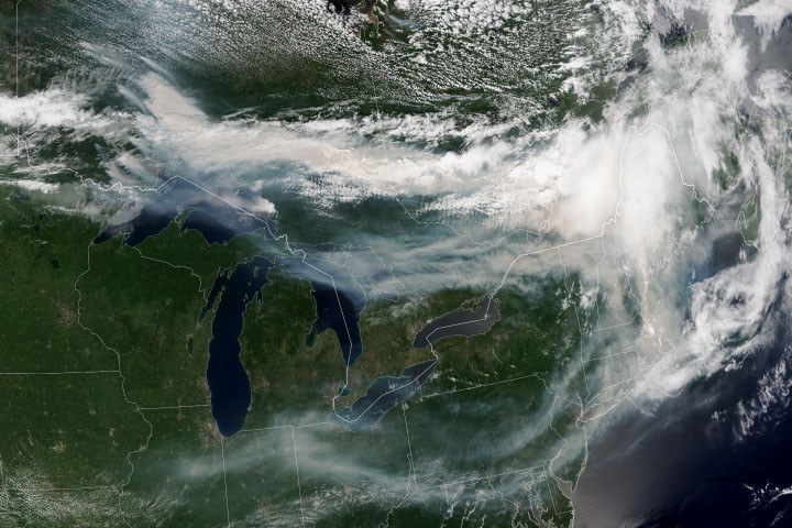
The extensive wildfire activity had profound atmospheric consequences, with smoke plumes traveling thousands of kilometers from their origin points. A striking image acquired by the NOAA-21 satellite on the afternoon of July 14, 2026, vividly captured the vast expanse of smoke billowing from the Ontario fires. This Joint Polar Satellite System (JPSS) satellite, part of a crucial network for environmental monitoring, provided critical data on the smoke’s distribution. Prevailing winds predominantly carried these smoke plumes southeastward, blanketing not only much of southern Ontario and parts of Quebec but also extending their reach across large swathes of the U.S. Midwest and Northeast.
The impact of this widespread smoke on air quality was varied and highly dependent on atmospheric conditions, particularly altitude. Where smoke remained high in the atmosphere, its direct impact on ground-level air quality was often negligible, manifesting more as a visible haze or altered sky color. However, in areas where the smoke descended closer to the ground, conditions rapidly deteriorated. AirNow, a collaborative effort by U.S. federal, state, and local agencies to provide air quality information, reported that air quality in major urban centers like Toronto reached "unhealthy levels." This classification signifies that individuals with respiratory sensitivities, children, and the elderly are particularly at risk, but even healthy individuals may experience adverse health effects. Public health advisories were widely disseminated, urging residents to limit outdoor activities, keep windows closed, and utilize air purifiers where available. The sheer scale of the smoke dispersal meant that millions of people across two countries were impacted by compromised air quality, prompting a significant public health response.

Health Ramifications Amidst a Heatwave
The health risks associated with the wildfire smoke were gravely compounded by an ongoing heatwave gripping the southern parts of Ontario and the broader region. The combination of elevated temperatures and poor air quality creates a particularly dangerous scenario for human health. Fine particulate matter (PM2.5) from wildfire smoke can penetrate deep into the lungs, exacerbating pre-existing respiratory conditions such as asthma, bronchitis, and chronic obstructive pulmonary disease (COPD). It can also trigger new respiratory symptoms, including coughing, wheezing, and shortness of breath, even in healthy individuals. Cardiovascular impacts, such as increased risk of heart attacks and strokes, have also been linked to prolonged exposure to wildfire smoke.
When these conditions are combined with extreme heat, the body’s physiological stress response is intensified. High temperatures place additional strain on the respiratory and cardiovascular systems, making individuals more susceptible to the harmful effects of air pollution. Vulnerable populations, including outdoor workers, the elderly, young children, and those with chronic health conditions, face a significantly elevated risk of heatstroke, heat exhaustion, and smoke-related illnesses. Public health officials issued urgent warnings, advising residents to stay hydrated, seek air-conditioned environments, and monitor local air quality indices closely. The dual threat underscored the complex and interconnected challenges posed by contemporary environmental crises, demanding integrated public health and emergency management strategies.
Monitoring the Blaze: Satellite Surveillance and Interagency Efforts
The ability to track and understand the vast scale of these wildfires and their atmospheric consequences relies heavily on advanced satellite technology and robust interagency collaboration. The NOAA-21 satellite, part of the Joint Polar Satellite System, provides crucial observational data, allowing scientists and emergency responders to monitor fire hotspots, smoke plume trajectories, and their impact on air quality in near real-time. Images from platforms like the NASA Earth Observatory, utilizing data from VIIRS (Visible Infrared Imaging Radiometer Suite) and other instruments, offer vital visual and scientific insights, aiding in situational awareness and public communication. These scientific tools are indispensable for understanding the dynamics of large-scale environmental phenomena.
Beyond satellite imagery, the Canadian Interagency Forest Fire Centre (CIFFC) plays a pivotal role in coordinating the national response. CIFFC acts as a central hub for information sharing, resource allocation, and strategic planning among federal, provincial, and territorial fire management agencies. This includes tracking active fires, monitoring hectares burned, and providing daily updates on the national fire situation. Furthermore, international collaboration is an increasingly critical component of wildfire management. The seasonal fire outlook, compiled by a consortium of wildland fire experts from the U.S., Canada, and Mexico, exemplifies this cross-border cooperation. These outlooks leverage shared expertise and data to forecast fire conditions and potential risks for the coming months, facilitating proactive resource deployment and strategic planning across North America. Such coordinated efforts are essential in managing a phenomenon that respects no national borders.
Broader Implications: Environment, Economy, and Future Preparedness
As of July 14, fires across Canada had consumed an estimated 1.9 million hectares (approximately 4.7 million acres) since the beginning of the year. While this figure, though substantial, remained well below the unprecedented season totals observed in the extreme fire years of 2023 and 2025 – which saw significantly larger areas burned – it still represents a profound environmental and economic impact. Environmentally, these fires contribute to habitat destruction, affecting biodiversity and disrupting delicate ecosystems. The release of vast quantities of carbon dioxide and other greenhouse gases from burning forests also contributes to climate change, creating a feedback loop where warmer, drier conditions exacerbate fire risk.
Economically, the impact extends beyond the direct costs of firefighting. Forestry, a cornerstone of the Canadian economy, faces significant disruptions, including timber losses and operational challenges. Tourism in affected regions can suffer, as smoke deters visitors and forces the closure of parks and natural attractions. The health-related costs, including increased hospitalizations and healthcare expenditures due to smoke exposure, add another layer of economic burden. Furthermore, the long-term recovery and restoration efforts for burned areas, including reforestation and ecological rehabilitation, represent substantial financial and logistical undertakings. The recurring intensity of these fire seasons necessitates a re-evaluation of land management practices, infrastructure resilience, and community preparedness strategies across the country.
Looking Ahead: The Remainder of the 2026 Fire Season
The trajectory of the 2026 wildfire season beyond mid-July remains a subject of ongoing monitoring and expert analysis. While 1.9 million hectares burned is significant, it pales in comparison to the record-breaking seasons of 2023 and 2025, which saw unprecedented destruction. However, the conditions that fueled the mid-July surge – persistent heat and dryness – often continue into August and September in many parts of Canada. The seasonal fire outlook, a collaborative assessment by wildland fire experts from Canada, the U.S., and Mexico, provides critical probabilistic forecasts for where fire conditions are more or less likely to intensify over the coming months. These outlooks consider various climatic factors, including drought conditions, temperature anomalies, and precipitation forecasts, to inform strategic planning.
The variability of the season underscores the challenges in predicting wildfire behavior and intensity. A sudden shift in weather patterns, such as significant rainfall or a prolonged cooling trend, could alleviate the current crisis. Conversely, continued hot and dry weather, particularly if accompanied by strong winds or frequent lightning, could lead to further escalation. Authorities remain on high alert, continuously adapting their strategies and deploying resources based on the latest scientific data and meteorological forecasts. The lessons learned from previous intense seasons, combined with advanced monitoring capabilities and interagency cooperation, will be crucial in mitigating the ongoing risks and preparing for the potential challenges that the latter half of the 2026 wildfire season may yet bring. The resilience of communities, the dedication of emergency responders, and the ongoing scientific efforts to understand and predict these complex environmental events will all play a part in shaping the ultimate outcome.