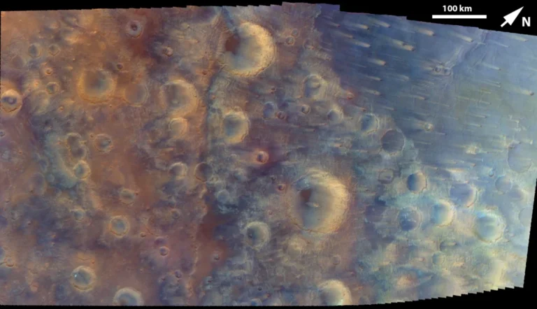


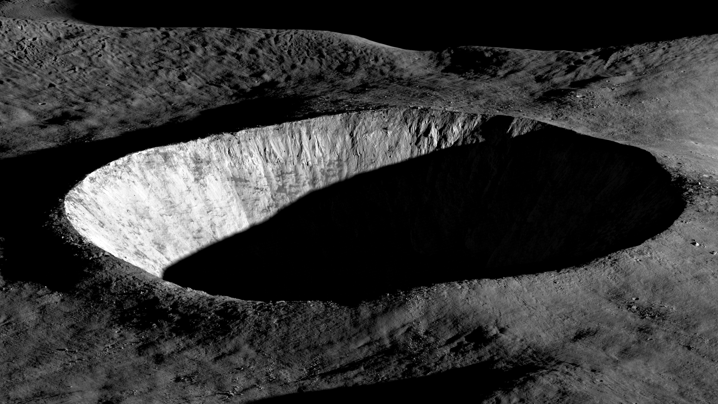
Early morning sunlight, casting long, dramatic shadows across the western wall and interior of an unnamed lunar crater, has been chosen by NASA’s Science Mission Directorate as its "Science Image of the Month" for March 2026. This evocative photograph, captured on August 30, 2023, by the Lunar Reconnaissance Orbiter Camera (LROC), serves as a poignant reminder of the enduring scientific mission of the Lunar Reconnaissance Orbiter (LRO) and its critical role in humanity’s renewed pursuit of lunar knowledge and eventual return.
The image, a testament to LROC’s unparalleled imaging capabilities, showcases the intricate topographical details of the lunar surface, illuminated at a low sun angle that accentuates geological features often obscured under direct light. Such imagery is not merely aesthetically pleasing; it provides invaluable data for geologists studying lunar impact processes, volcanic activity, and the overall evolution of Earth’s closest celestial neighbor. The deep shadows hint at the ruggedness of the crater floor and walls, information crucial for mission planners evaluating potential landing sites for future robotic and human expeditions.
The Lunar Reconnaissance Orbiter Mission: A Decade and a Half of Discovery
Launched in June 2009 aboard an Atlas V rocket from Cape Canaveral Air Force Station, NASA’s Lunar Reconnaissance Orbiter (LRO) embarked on a primary mission designed to prepare for humanity’s future in space. Operated by NASA’s Goddard Space Flight Center, LRO was initially slated for a one-year mission but has far surpassed its expected lifespan, continuing to orbit the Moon and deliver groundbreaking data over fifteen years later. Its longevity is a testament to its robust design and the sustained scientific interest in the Moon.
LRO’s initial objectives were multi-faceted and ambitious:
- 3D Topographical Mapping: To create the most detailed three-dimensional maps of the lunar surface, essential for identifying safe and scientifically interesting landing sites for both robotic and human missions. This precise mapping aids in understanding surface hazards, slopes, and terrain variations.
- Resource Identification: To scout for potential resources, most notably water ice, especially in the permanently shadowed regions (PSRs) of the lunar poles. The presence of water ice is considered a game-changer for sustainable lunar operations, as it can be processed into potable water, breathable oxygen, and rocket fuel.
- Radiation Environment Investigation: To characterize the lunar radiation environment, a critical factor for ensuring the safety of human explorers during long-duration stays on the Moon. Instruments like the Cosmic Ray Telescope for the Effects of Radiation (CRaTER) were specifically designed for this purpose.
- Technology Demonstration: To test and prove new technologies that would be vital for future lunar exploration, including advanced navigation systems and communication protocols.
These foundational goals laid the groundwork for subsequent lunar endeavors, including the ambitious Artemis program. LRO’s data has been instrumental in shaping our understanding of the Moon’s geology, resource potential, and environmental challenges, making it one of NASA’s most successful and impactful planetary science missions.
LROC: The High-Resolution Imager Behind the Discoveries
At the heart of LRO’s imaging prowess is the Lunar Reconnaissance Orbiter Camera (LROC), a sophisticated system comprising three distinct cameras managed by Arizona State University. This suite includes two Narrow Angle Cameras (NACs), which capture high-resolution black and white images of the lunar surface, and one Wide Angle Camera (WAC), which provides broader, lower-resolution color images and supports photometric studies.
The NACs are particularly remarkable, capable of resolving features as small as 50 centimeters (approximately 20 inches) from LRO’s operational altitude of around 50 kilometers (31 miles). This extraordinary resolution has allowed scientists to meticulously examine the lunar surface like never before, identifying boulders, small craters, and even the tracks left by Apollo astronauts. The stereo imaging capabilities of the NACs, achieved by capturing images of the same area from different angles, are crucial for constructing the precise 3D topographical maps that were a primary mission objective.
The WAC, on the other hand, collects data across multiple spectral bands, enabling the study of surface composition and mineral distribution. Together, LROC’s cameras have produced an unprecedented visual catalog of the Moon, revealing the intricate details of its ancient and dynamic surface. The image selected as the "Science Image of the Month" exemplifies the NACs’ ability to capture stunning details, using the interplay of light and shadow to highlight topographical relief that might otherwise be overlooked. This technique is particularly valuable for identifying subtle changes in elevation, which are crucial for characterizing safe landing zones and understanding geological formations.
Key Milestones and Contributions of the LRO Mission
Throughout its extended mission, LRO has achieved numerous scientific and technological breakthroughs, cementing its legacy as a cornerstone of lunar exploration:
- 2011 – Highest-Resolution Topographical Map: Just two years after launch, LRO data was used to produce the highest-resolution, near-topographical map of the Moon. This achievement revolutionized lunar cartography, providing unprecedented detail for mission planning and geological research. The precise elevation data allowed for accurate modeling of lunar terrain, crucial for trajectory planning and hazard avoidance for future landers and rovers.
- 2014 – Interactive Lunar North Pole Mosaic: An interactive mosaic of the lunar North Pole was published, providing a comprehensive view of this scientifically critical region. The polar regions are of immense interest due to the confirmed presence of water ice in permanently shadowed craters, a resource vital for future lunar bases. LRO’s mapping efforts here have been pivotal in identifying potential resource extraction sites.
- High-Resolution Imaging of Landing Sites: LRO has meticulously photographed numerous lunar landing sites, including those of NASA’s Apollo missions, the Soviet Luna probes, and China’s Chang’e missions. These images serve multiple purposes: verifying the locations of historical landings, studying the long-term effects of human presence on the lunar surface, and providing valuable context for archaeological and engineering analyses of past missions. For instance, images of the Apollo sites clearly show the descent stages of the Lunar Modules, astronaut footprints, and equipment left behind, offering tangible proof of human endeavor on another celestial body.
- First Demonstration of Laser Communication: LRO conducted the first successful demonstration of laser communication with a lunar satellite. This groundbreaking technological achievement showcased the potential for high-bandwidth data transmission between Earth and lunar orbiters, a capability that will be essential for supporting future human missions and complex scientific payloads that generate vast amounts of data. This technology promises to enhance communication efficiency and reduce reliance on traditional radio frequencies.
- Confirmation of Water Ice: While not a direct imager of ice, LRO’s suite of instruments, particularly the Lunar Exploration Neutron Detector (LEND) and the Diviner Lunar Radiometer Experiment, provided compelling evidence and detailed mapping of hydrogen-rich deposits consistent with water ice in the Moon’s polar regions. This data built upon earlier indications from missions like Clementine and Lunar Prospector, transforming the understanding of lunar resources and significantly influencing future exploration strategies.
The Resurgence of Lunar Exploration and the Artemis Program
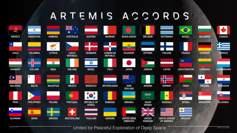
The ongoing mission of LRO and the continuous flow of data it provides are intricately linked to the broader resurgence of interest in lunar exploration. Governments and private entities worldwide are actively pursuing lunar missions, driven by scientific curiosity, strategic interests, and the potential for resource utilization. NASA’s Artemis program stands at the forefront of this new era, aiming to return humans to the Moon, establish a sustainable lunar presence, and use the Moon as a proving ground for future human missions to Mars.
LRO’s data is directly feeding into the Artemis program’s planning. The high-resolution topographical maps are crucial for selecting precise and safe landing sites for the Artemis III mission, which aims to land the first woman and the next man on the Moon, with a focus on the lunar South Pole. The detailed maps of permanently shadowed regions are guiding efforts to understand the distribution and accessibility of water ice, a resource vital for sustaining future lunar habitats and for producing rocket fuel (propellant). By identifying potential hazards like steep slopes, deep craters, and rough terrain, LRO mitigates risks for both robotic landers under the Commercial Lunar Payload Services (CLPS) initiative and future human crews.
Furthermore, LRO’s insights into the lunar radiation environment are indispensable for designing radiation-hardened spacecraft and habitats, as well as for developing operational protocols to protect astronauts from solar particle events and galactic cosmic rays. The mission serves as a critical precursor, providing the fundamental knowledge and context necessary for humanity to not just visit, but to live and work on the Moon.
Engaging the Public: NASA’s Science Image of the Month Initiative
The selection of the unnamed crater image as the NASA Science Image of the Month for March 2026 underscores NASA’s commitment to public outreach and scientific communication. Each month, NASA’s Science Mission Directorate curates and features a compelling image, aiming to inspire curiosity and engage a global audience with the wonders of space science.
This initiative goes beyond simply showcasing beautiful pictures. It provides context, often linking to related scientific topics, educational activities, and even games, making complex scientific endeavors accessible to students, educators, and the general public. By offering desktop wallpaper downloads, NASA ensures that these breathtaking views of the cosmos can adorn personal devices, serving as daily reminders of ongoing exploration and discovery. The chosen image of the lunar crater, with its striking interplay of light and shadow, is not only scientifically valuable but also possesses a distinct aesthetic appeal that can captivate imaginations and foster a deeper appreciation for planetary science. It serves as a visual ambassador for the scientific work being done, encouraging public support and inspiring the next generation of scientists and engineers.
Perspectives from NASA and the Scientific Community
Scientists and mission managers consistently emphasize the unparalleled value of LRO’s continued operations. Dr. Noah Petro, the LRO Project Scientist at NASA’s Goddard Space Flight Center, has frequently highlighted that LRO continues to provide critical data that "fundamentally changes our understanding of the Moon." The LROC team at Arizona State University, led by Dr. Mark Robinson, regularly publishes findings that push the boundaries of lunar geology and surface processes.
NASA Administrator Bill Nelson has often underscored the critical role of precursor missions like LRO in "paving the way for the Artemis Generation." He has stated that the data gathered by LRO is not just about understanding the Moon, but about "enabling a sustainable human presence beyond Earth." The scientific community globally benefits from LRO’s publicly available data archives, with researchers using the extensive imagery and other instrument data to publish hundreds of peer-reviewed articles, further advancing lunar science. The detailed images of the Moon’s surface, like the unnamed crater, allow researchers to perform virtual geological field work, identifying features that might be targets for future landers or sample return missions.
Long-Term Impact and the Future of Lunar Science
The long-term implications of LRO’s mission are profound and far-reaching. Scientifically, it has provided an unprecedented geological context for understanding the Moon’s formation, evolution, and its relationship with Earth. The detailed mapping of impact craters, volcanic features, and tectonic structures has revolutionized models of lunar history. The confirmation and mapping of water ice deposits have transformed the Moon from a barren rock into a potential staging post for deep-space exploration, where resources can be extracted and utilized.
Technologically, LRO has advanced remote sensing techniques, improved our ability to navigate and communicate in deep space, and demonstrated the resilience of long-duration orbital missions. The experience gained from operating LRO for over a decade and a half provides invaluable lessons for future complex missions.
For exploration, LRO has directly de-risked future human and robotic missions by providing detailed maps for landing site selection and hazard assessment. It has informed the design of habitats, rovers, and extravehicular activities for astronauts. The mission embodies the spirit of scientific inquiry and technological innovation that drives space exploration. As the Artemis program progresses towards returning humans to the lunar surface and establishing a permanent presence, LRO’s foundational data will remain indispensable. The continuous stream of high-resolution images, like the captivating view of the unnamed crater, will not only fuel scientific research but also continue to inspire new generations to look up at the Moon and dream of the possibilities it holds. The legacy of LRO will undoubtedly resonate through decades of future lunar exploration, making it a true icon of space science.
Image credit: NASA’s Goddard Space Flight Center/Intuitive Machines