

The Mars Science Laboratory (MSL) Curiosity rover is in the final phase of its extensive "boxwork campaign," meticulously investigating the unique geological contacts between the boxwork unit and the underlying layered sulfate unit. As of Earth planning date Friday, March 13, 2026, and extending through March 18, 2026, the rover has been conducting a series of detailed observations and analyses, preparing to transition to new terrain. This critical period, detailed by Catherine O’Connell-Cooper, APXS Strategic Planner and Payload Uplink/Downlink Lead from the University of New Brunswick, Canada, marks a significant milestone in Curiosity’s extended mission to understand Mars’ ancient habitability.
The Boxwork Campaign: A Window into Martian Past
The "boxwork campaign," a focused investigative period spanning approximately two years, has centered on a distinctive geological formation characterized by intricate, often angular, structures resembling cellular patterns or honeycomb. These "boxwork structures" are believed to have formed through the infilling of fractures in the bedrock by minerals precipitated from ancient groundwater. Over eons, as the surrounding, softer rock eroded away, these harder, mineral-filled networks were left standing in relief, creating the distinctive textures observed by Curiosity. The campaign’s primary objective has been to characterize these structures, understand their formation mechanisms, and investigate their relationship with the surrounding geological units, particularly the layered sulfate unit.
The layered sulfate unit itself is a crucial component of Mount Sharp (Aeolis Mons), the central peak of Gale Crater that Curiosity has been ascending since 2014. These sulfate-rich layers are of immense interest to planetary scientists because they often represent periods in Martian history when water was present but potentially more acidic or evaporating, contrasting with earlier, potentially more neutral-pH aqueous environments. Understanding the transition between different mineralogies and geological structures provides vital clues about the changing environmental conditions on early Mars and its potential for supporting microbial life.
Previously, the rover explored more pronounced boxwork structures at sites like "Nevado Sajama," where iconic images, dubbed the "boxwork postcard," were captured, offering a striking visual testament to these geological marvels. The current focus is on the uppermost portion of the boxwork unit, where the bedrock appears smoother and the boxwork structures are less overtly defined, necessitating even more precise and high-resolution observations to discern their characteristics and contacts. The team has meticulously traversed through these units, crossing back and forth to ensure comprehensive data collection on the intricate interfaces.
Intensive Scientific Operations: A Week in Review
The period between March 13 and March 18, 2026, was marked by an intense flurry of scientific activities, leveraging Curiosity’s advanced suite of instruments to gather as much data as possible before the rover drives away from this unique geological locale.
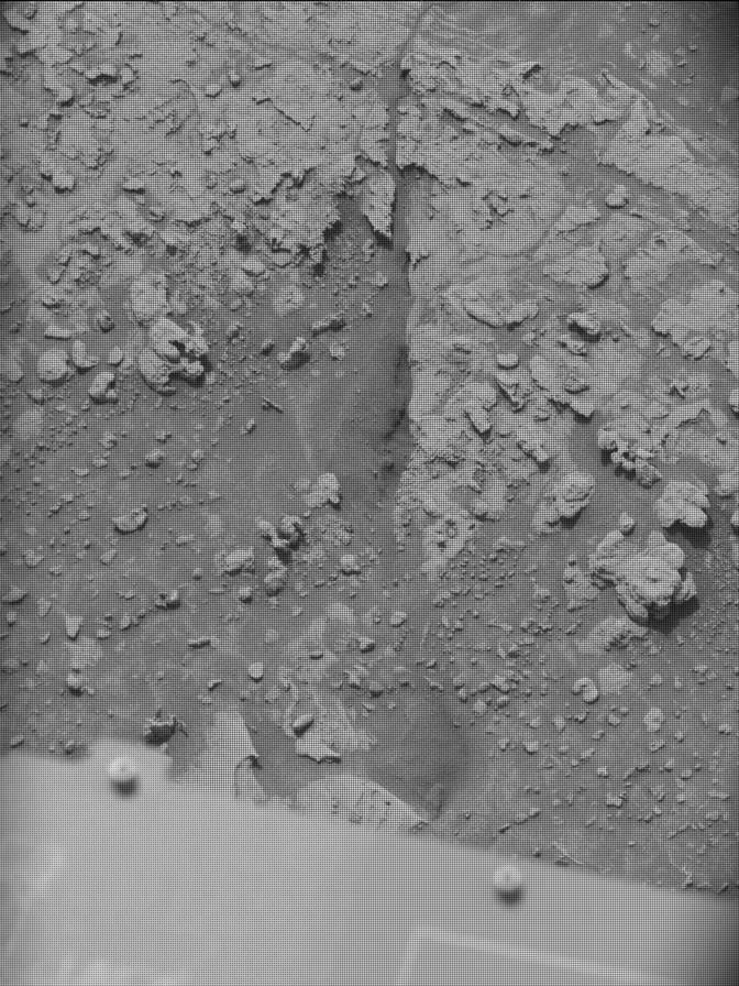
On Monday, March 16, the Mars Hand Lens Imager (MAHLI) was heavily engaged, capturing high-resolution, close-up images of several key targets, all named after geographical locations in the Andes of South America. MAHLI imaged "Piedras Bonitas" and "La Calera." MAHLI, mounted on the rover’s robotic arm, functions much like a geologist’s hand lens, providing microscopic views of rocks and soil. These images are crucial for understanding the fine-scale textures, grain sizes, and mineralogical details of the Martian surface, which can reveal clues about formation processes, alteration by water, and the presence of any microscopic biological features if they existed.
Concurrently, the Alpha Particle X-ray Spectrometer (APXS) was deployed to analyze "La Calera" after it had been brushed clean. APXS works by irradiating the rock surface with alpha particles and X-rays, then measuring the energy spectrum of the X-rays emitted by the atoms in the target. This allows scientists to determine the elemental composition of the rock, including elements like iron, sulfur, calcium, and potassium. For "La Calera," the APXS data would provide critical information on the chemical makeup of the brushed bedrock, allowing comparisons with other sulfate-rich units and helping to characterize the mineralogy of the contact zone. Such elemental data can differentiate between various types of sulfates and other minerals, offering insights into the water chemistry and precipitation conditions that prevailed during their formation.
The Mast Camera (Mastcam) had an exceptionally busy week, fulfilling a long wish list of targets as the campaign neared its conclusion. Mastcam, a pair of cameras capable of taking true-color images and videos, is vital for geological context, panoramic imaging, and atmospheric observations. On Monday, Mastcam acquired an 18×1 mosaic, consisting of 18 individual frames stitched together along a single row, focused on the southern contact between the boxwork and layered sulfate units. This mosaic would provide a broad, high-resolution view of the geological boundary, essential for understanding the spatial relationships and larger-scale stratigraphy. Additionally, Mastcam imaged "Yungas," a highly veined area, to study the intricate network of mineralized fractures, and "Ujina," providing cross-sectional stratigraphy views that reveal the layering and depositional history of the rock units.
Friday’s Focused Investigations and Environmental Monitoring
The scientific intensity continued on Friday, March 20, with further targeted observations. MAHLI and APXS collaborated on analyzing "Jaruma," a brushed, nodular bedrock target. Nodules, or concretions, are often formed by the precipitation of minerals from aqueous solutions within sediments or rocks. Their presence and composition can indicate the past presence of water and the chemical conditions that led to their formation. The brushing action, performed by the rover’s Dust Removal Tool, clears away superficial dust, allowing MAHLI to capture clearer images of the rock’s true texture and APXS to obtain more accurate elemental compositions of the underlying material.
Another significant target for MAHLI and APXS was "Constancia," an unbrushed location featuring a larger nodule or a cluster of smaller nodules. Analyzing both brushed and unbrushed surfaces, as well as different types of nodular features, allows scientists to compare the surface dust’s effect on readings and to understand the variability within these intriguing concretions. The ability to click on the target names to view the MAHLI images directly provides an immediate visual context to the scientific investigations, allowing the public and researchers alike to examine the features being studied.
Mastcam’s extensive work continued on Friday with the acquisition of a 19×3 mosaic, named "El Misti," also targeting the southern contact between the boxwork and layered sulfate units. This larger mosaic, comprising 57 individual frames (19 frames across three rows), offers an even more comprehensive and potentially stereoscopic view of the contact, enabling scientists to build 3D models and conduct detailed stratigraphic analyses. These high-resolution contextual images are indispensable for mapping geological features and understanding the spatial distribution and evolution of the boxwork unit in relation to its surroundings. Furthermore, Mastcam acquired two mosaics on "Salar de Maricunga," aimed at characterizing light-toned bedrock observed in the drive direction. Light-toned materials on Mars often indicate the presence of specific minerals, such as evaporite salts or altered volcanic ash, which can further inform the story of past water activity.
Beyond geological investigations, environmental monitoring remained a critical aspect of the rover’s operations. Understanding the Martian atmosphere, particularly its dust content, is vital for both scientific understanding and mission safety. Navcam, the Navigation Camera, was used for dust-devil monitoring and surveys, capturing images of dust devils that provide insights into atmospheric dynamics and surface wind patterns. Zenith and suprahorizon movies were also acquired, which track the movement of atmospheric dust and clouds directly overhead and along the horizon. Mastcam taus, a measurement of atmospheric opacity, further contributed to the continuous monitoring of dust in the atmosphere. These environmental data sets are crucial for long-term climate studies on Mars, helping scientists understand seasonal variations, dust storm initiation, and the overall atmospheric environment that influences surface processes and potential habitability.
The Drive Ahead: Towards New Discoveries
As the detailed characterization of the boxwork unit concludes, Curiosity is poised for its next journey. The weekend drive is planned to take the rover approximately 23 meters (about 75 feet) to the west-southwest. This strategic maneuver will position Curiosity closer to exiting the boxwork unit entirely, propelling it towards new geological formations and fresh scientific inquiries. Each drive is carefully planned by a dedicated team of engineers and scientists, ensuring the rover’s safety while maximizing scientific return.
Catherine O’Connell-Cooper, a key member of the "Fracture Townies" – the informal name for the boxwork working group – reflected on the campaign’s journey, which began with planning nearly two years before Curiosity ever touched the unit. This long-term dedication underscores the meticulous preparation and foresight that goes into every phase of a Mars mission. The sentiment among the team is described as "bittersweet" – a mixture of satisfaction at the immense amount of data gathered and a touch of wistfulness at leaving a site that has yielded so many fascinating discoveries. However, the sheer volume and richness of the data and imagery collected mean that the "Fracture Townies" will have ample material to analyze and interpret for years to come, ensuring that the scientific legacy of the boxwork campaign will continue to unfold long after Curiosity has moved on.
Broader Implications and Future Endeavors
The concluding phase of the boxwork campaign and the transition to new terrains represent another significant chapter in Curiosity’s remarkable exploration of Gale Crater. The findings from this campaign will profoundly enhance our understanding of how water interacted with rocks on ancient Mars, specifically during periods when sulfate minerals were forming. This provides crucial context for piecing together the planet’s hydrological history, from potentially warm, wet environments to more arid and acidic conditions.
The detailed analysis of mineral composition, rock textures, and geological contacts contributes directly to the overarching goal of the Mars Science Laboratory mission: to assess the past habitability of Mars and to search for evidence of organic molecules. By understanding the processes that formed these boxwork structures and sulfate layers, scientists can better identify environments that might have once supported microbial life, and where potential biosignatures might be preserved.
Curiosity’s extended mission, now well into its second decade, continues to push the boundaries of planetary exploration. The continuous stream of high-quality data from diverse geological settings within Gale Crater provides invaluable insights that inform future missions, including the Mars Sample Return program and eventual human exploration endeavors. The methodologies and discoveries made by Curiosity, particularly in characterizing complex geological transitions, serve as a testament to the power of robotic exploration and the enduring human quest to understand our place in the cosmos. The rover’s onward journey promises new vistas and challenges, each offering further opportunities to unravel the deep geological secrets of the Red Planet.