


A groundbreaking quality assessment report from NASA’s Commercial Satellite Data Acquisition (CSDA) program, issued on March 9, 2026, has formally approved the use of precipitation radar data from Tomorrow.io for NASA scientific applications. This pivotal decision follows a rigorous evaluation process and signifies a significant milestone in the integration of commercial Earth observation data into federal scientific research, promising to enhance our understanding of global weather patterns and climate dynamics.
Rigorous Assessment Underpins Approval
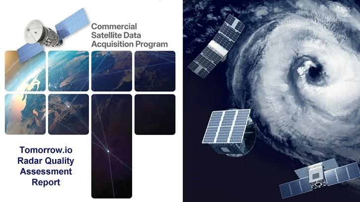
The comprehensive Commercial Satellite Data Acquisition Program Tomorrow.io Radar Quality Assessment Report meticulously details the evaluation undertaken by a team of NASA subject matter experts (SMEs). These specialists were tasked with analyzing the data quality of the Ka-band Precipitation Radars onboard Tomorrow.io’s R1 and R2 spacecraft, crucial components of the company’s burgeoning commercial weather constellation. The assessment focused on the Level 2 Precipitation products, which represent processed data ready for scientific analysis, and the critical aspect of geolocation accuracy – ensuring that the data points precisely correspond to their geographical locations on Earth.
The findings from the NASA SMEs largely corroborated the analyses provided by Tomorrow.io in its own algorithm theoretical basis document, a foundational technical report outlining the scientific principles and mathematical procedures used to process raw data into usable products. Specifically, the geolocation assessment demonstrated an "excellent correlation" of 0.98 when compared against a high-resolution digital elevation model (DEM) reference. This near-perfect correlation underscores the precision with which Tomorrow.io’s sensors can pinpoint the exact location of observed weather phenomena, a fundamental requirement for accurate scientific modeling and forecasting.
Further validation came from comparisons with established ground radar networks. The satellite-derived precipitation data showed good agreement with ground-based measurements, achieving correlation coefficients of 0.73 for the R1 spacecraft and an even higher 0.93 for the more recently launched R2. While both figures indicate a strong relationship between the commercial satellite data and ground truth, the improved performance of R2 highlights the rapid advancements and refinements possible within the commercial space sector. The report also noted systematic biases: R1 exhibited a bias of -22%, while R2 showed a significantly reduced bias of -6%. These biases indicate a tendency for the satellite radars to slightly underestimate precipitation compared to ground measurements, a characteristic that can be accounted for in scientific models. However, the substantial reduction in bias from R1 to R2 demonstrates the iterative improvements Tomorrow.io is making to its sensor technology and data processing algorithms. Based on these compelling results, the SMEs concluded that Tomorrow.io’s precipitation radar data should be considered for NASA scientific use, contingent upon its alignment with specific science objectives and application needs, thus opening the door for its integration into a wide array of research initiatives.
Tomorrow.io’s Vision Realized
For Tomorrow.io, the independent validation by NASA’s CSDA program represents a monumental achievement and a critical endorsement that instills confidence within the broader scientific community regarding the reliability and scientific rigor of commercial Earth observation data. Rei Goffer, Chief Strategy Officer and Founder of Tomorrow.io, articulated the profound significance of this validation: “When NASA’s own subject matter experts validate that a commercially built space-based radar system can contribute meaningfully alongside programs like NASA’s Global Precipitation Measurement missions, that opens a new chapter for Earth observation.” Goffer emphasized the company’s foundational vision, stating, “We built these instruments to demonstrate that the commercial sector can deliver science-quality data from space, and we’re proud that NASA’s assessment supports that vision.” This statement not only celebrates the technical accomplishment but also frames it within the larger context of expanding access to high-quality data through innovative commercial solutions.
Tomorrow.io, a company at the forefront of weather intelligence, has invested heavily in developing and deploying its proprietary constellation of Ka-band precipitation radars. Ka-band radar technology is particularly adept at detecting light to moderate precipitation, including drizzle and snow, which are often challenging for other types of remote sensing instruments. Its ability to penetrate clouds and provide vertical profiles of precipitation makes it invaluable for detailed atmospheric studies. By deploying a constellation, Tomorrow.io aims to provide near-global, high-revisit-rate precipitation data, filling critical gaps in observational coverage, particularly over oceans and remote land areas where ground-based radars are scarce or nonexistent. The NASA approval is a powerful affirmation of their technological prowess and their commitment to producing data that meets the stringent requirements of scientific research.
NASA’s Strategic Imperative: The CSDA Program
The integration of commercial data sources like Tomorrow.io’s is a cornerstone of NASA’s evolving strategy in Earth science. The Earth Science Division (ESD) established the Commercial Satellite Data Acquisition (CSDA) program with the explicit mission to identify, evaluate, and acquire commercial remote sensing data that can effectively enhance NASA’s existing Earth science research and applications. This strategic initiative was born from the recognition that the rapidly expanding commercial space sector offers unprecedented opportunities to augment government-led observational capabilities, potentially providing more frequent observations, novel data types, and cost-effective solutions.
The CSDA program provides structured "on-ramping" opportunities for emerging commercial satellite data vendors, creating a clear pathway for innovative private-sector companies to demonstrate their capabilities and integrate their data into NASA’s vast scientific ecosystem. This continuous integration mechanism ensures that NASA can leverage cutting-edge data sources as the private sector continues to innovate at an accelerating pace. By fostering these public-private partnerships, NASA’s ESD aims to achieve several critical objectives: accelerate scientific discovery, expand the applications of Earth observation data for its research community, and ultimately, deliver tangible societal benefits ranging from improved weather forecasting to enhanced climate modeling and disaster preparedness.
Since its inception as a pilot program, CSDA has conducted three distinct on-ramp activities, leading to the addition of several vendors into sustainment – meaning their data has been deemed suitable for ongoing acquisition and use. Over time, the program has streamlined its evaluation process, transitioning to highly efficient, SME-led data assessments. This approach has not only accelerated review cycles but also deepened NASA’s engagement with the burgeoning commercial data ecosystem, fostering a collaborative environment where industry innovation can directly support governmental scientific mandates. The CSDA’s evaluation criteria, though rigorous, are designed to be transparent and comprehensive, typically encompassing:
- Data Quality and Scientific Utility: Assessing accuracy, precision, resolution, and relevance to NASA’s scientific objectives.
- Technical Maturity: Evaluating the robustness of the sensor technology, data processing algorithms, and operational reliability.
- Data Accessibility and Usability: Ensuring data formats, metadata, and licensing agreements facilitate ease of integration and use by NASA researchers.
- Cost-Effectiveness: Determining if commercial data acquisition offers a financially viable alternative or complement to traditional government missions.
- Data Continuity and Longevity: Evaluating the vendor’s ability to provide sustained data streams over time.
This meticulous approach guarantees that NASA gains timely access to high-quality, mission-relevant commercial data. Concurrently, it provides invaluable feedback to private-sector providers, encouraging continuous innovation, improvements in data products, and a closer alignment of industry capabilities with NASA’s evolving scientific needs.
Broader Implications for Earth Observation and Commercial Space
The validation of Tomorrow.io’s precipitation radar data carries profound implications that extend far beyond a single data acquisition contract. It represents a significant inflection point for both Earth science and the commercial space industry.
Enhancing Global Precipitation Monitoring: Precipitation is a fundamental component of Earth’s water cycle and a critical driver of weather and climate. Accurate and timely precipitation data is essential for a myriad of applications, including:
- Weather Forecasting: Improving short-term weather predictions, especially for extreme events like floods and droughts.
- Climate Modeling: Refining global climate models to better project future climate scenarios and understand climate change impacts.
- Hydrological Studies: Managing water resources, predicting river flows, and assessing agricultural productivity.
- Disaster Management: Providing crucial information for emergency response during storms and other weather-related hazards.
Current precipitation monitoring relies on a combination of ground-based radars, rain gauges, and satellite missions like NASA’s Global Precipitation Measurement (GPM) constellation. While GPM provides highly accurate, detailed measurements, its revisit rate over specific regions can be limited. Commercial constellations like Tomorrow.io’s, with their potentially higher number of satellites and more frequent observations, can significantly enhance the temporal and spatial resolution of global precipitation data, offering a more complete and dynamic picture of rainfall and snowfall worldwide, particularly over vast ocean expanses and remote continents where traditional observations are sparse.
Complementing Existing NASA Missions: The approved commercial data is not intended to replace existing NASA missions but rather to complement them. Data from Tomorrow.io can augment missions like GPM by providing denser coverage, potentially filling gaps between GPM’s more detailed but less frequent passes. This synergistic approach allows NASA to leverage the strengths of both government-led, science-focused missions and agile, commercially-driven constellations, creating a more robust and comprehensive global observing system.
Validation of the Commercial Space Model: This approval serves as a powerful validation for the entire commercial space sector. It demonstrates that private companies possess the capability to develop, launch, and operate sophisticated instruments that can produce data meeting the rigorous scientific standards of agencies like NASA. Such a stamp of approval can significantly boost investor confidence in commercial Earth observation ventures, fostering further innovation and investment in the sector. It signals a maturation of the commercial space industry, moving beyond simple imagery to delivering highly specialized, science-grade measurements.
Future of Public-Private Partnerships: The success of the CSDA program with Tomorrow.io solidifies the model of public-private partnerships as a viable and effective strategy for advancing scientific research and addressing global challenges. This collaborative approach allows government agencies to access innovative technologies and data streams more rapidly and potentially more cost-effectively, while providing commercial entities with critical validation and market opportunities. It sets a precedent for how future scientific endeavors, from climate monitoring to planetary exploration, might increasingly involve contributions from the private sector.
Global Impact and Future Outlook:
Ultimately, improved precipitation data translates into better understanding of our planet and more informed decision-making. Enhanced capabilities in weather forecasting can save lives and protect property, while a deeper comprehension of precipitation patterns is vital for adapting to and mitigating the effects of climate change. The integration of Tomorrow.io’s data into NASA’s scientific toolkit represents a leap forward in our collective ability to observe, understand, and predict Earth’s complex systems.
As the CSDA program continues to evolve, the expectation is that more commercial vendors will follow Tomorrow.io’s path, bringing an even greater diversity of data types and observational capabilities to NASA’s Earth science community. The future of Earth observation is increasingly a collaborative one, where the innovation and agility of the commercial sector, validated by the scientific rigor of governmental agencies, combine to push the boundaries of our knowledge and benefit society on a global scale.
To delve deeper into the specifics of this landmark assessment, the Commercial Satellite Data Acquisition Program Tomorrow.io Radar Quality Assessment Report is publicly available on the CSDA website. Further information regarding the CSDA program’s comprehensive process for identifying and evaluating commercial satellite vendors, as well as insights into Tomorrow.io’s commercial data offerings, can also be found on the CSDA website and through their Vendor Focus webinar series.