


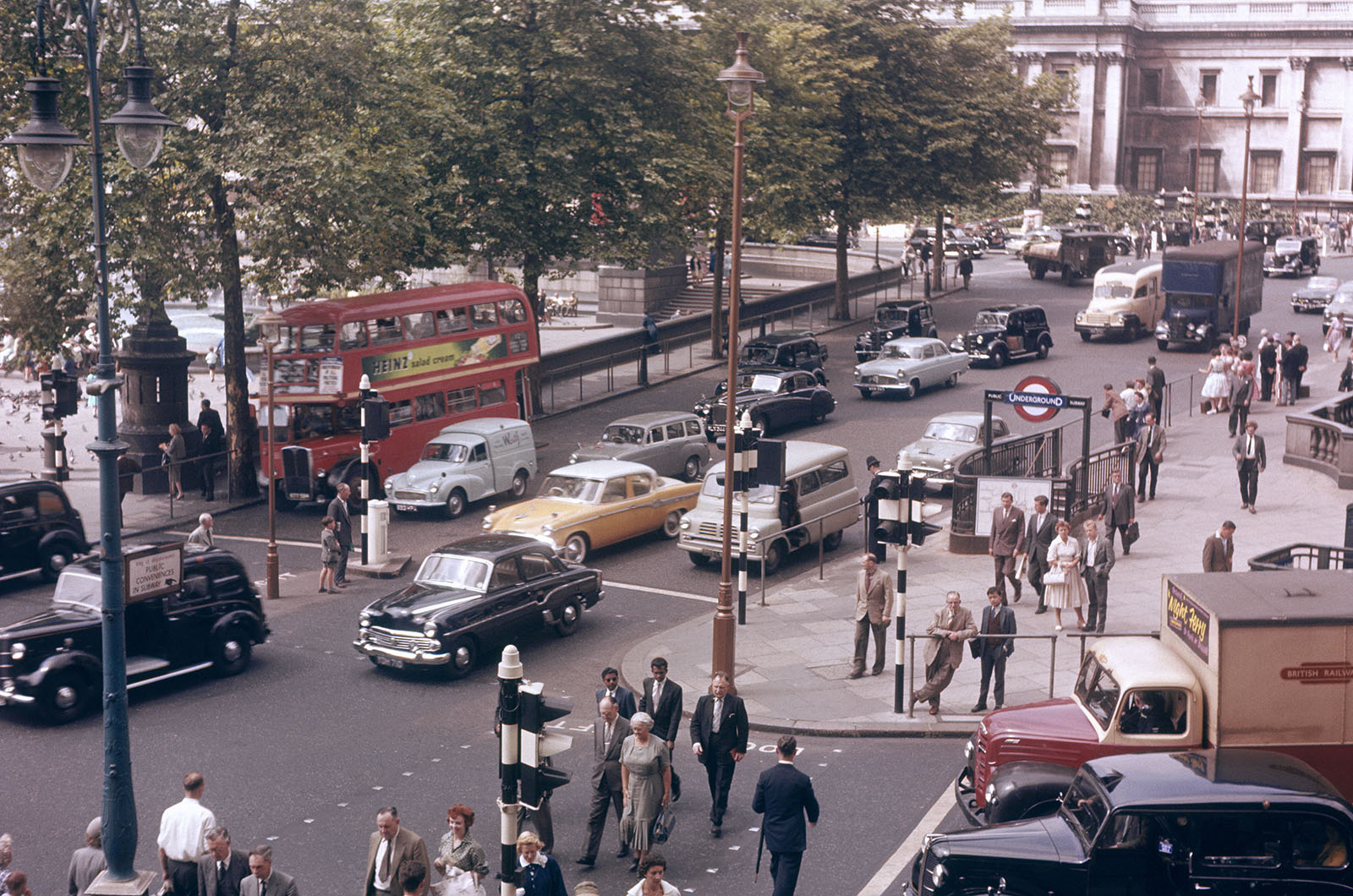
The landscape of urban transit in the United Kingdom has undergone a radical transformation over the last seven decades, moving from a period of discretionary navigation to a highly regulated, digitally monitored environment. In 1952, the experience of navigating London’s arterial roads was characterized by what historians and motoring enthusiasts describe as "organized chaos." This era, captured vividly in archival footage from British Pathé, presents a stark contrast to the contemporary motorist’s reality, which is defined by a dense network of signage, automated enforcement, and environmental zoning. The transition from the mid-20th century to the present day reflects not only advancements in technology but also a fundamental shift in the philosophy of urban planning and public safety.
The Mechanical and Social Context of 1952 London
In the early 1950s, the British automotive industry was in a state of post-war transition. Vehicles such as the Morris Minor, the Austin A40, and the Hillman Minx dominated the streets, most of which lacked the sophisticated signaling systems taken for granted today. A primary feature of these vehicles was the "trafficator"—a semaphore arm that swung out from the B-pillar to indicate a turn. As contemporary accounts from the period noted, the use of these devices was often subtle; a "little flip" of the trafficator was understood as an invitation or a tentative statement of intent rather than a definitive signal. This reliance on nuance meant that driving required a high level of interpersonal intuition and informal communication between motorists.
Beyond mechanical signals, the role of the Metropolitan Police was central to the flow of the city. Before the widespread installation of automated traffic lights, police officers stationed at major junctions dictated the movement of vehicles through hand gestures. These officers utilized a specific vocabulary of signals, including a "hurry up" gesture to clear congestion. This human-centric model of traffic management remained the standard until the mid-1970s, by which time the number of automated traffic light sets in London had reached 1,000, rendering the manual direction of traffic largely obsolete.
Navigational Challenges in the Pre-Digital Age
The absence of satellite navigation and real-time traffic updates in 1952 placed a significant burden of preparation on the driver. Navigating London required a mastery of landmarks and a deep familiarity with the city’s geography. However, even for the experienced "regular" driver, the sheer volume of traffic and the physical layout of the city often obscured famous landmarks like Eros in Piccadilly Circus or Nelson’s Column in Trafalgar Square. Drivers were forced to develop "crafty" routes to dodge choked spots, relying on physical maps—most notably the Geographers’ A-Z Street Atlas, first created by Phyllis Pearsall in 1936—and a keen sense of direction.
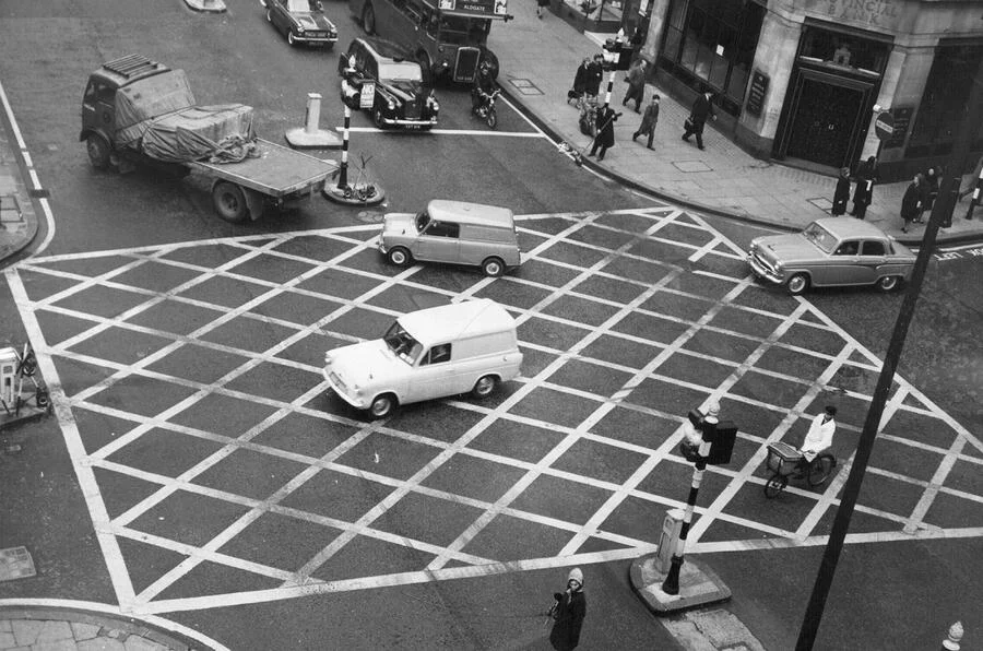
In this era, the visual environment of the road was remarkably sparse. Modern motorists would find the 1952 streetscape "strikingly minimal." There were no white lines to demarcate lanes, no painted turn arrows, and a complete absence of the yellow lines that now dictate parking and waiting restrictions. The concept of the "hatched box junction," designed to prevent gridlock by prohibiting entry unless the exit is clear, would not be introduced until 1964. Consequently, the efficiency of a junction depended almost entirely on the discretion and cooperation of individual drivers.
A Chronology of Infrastructure and Regulation
The evolution of London’s roads can be traced through a series of legislative and design milestones that sought to bring order to the increasing volume of post-war traffic.
- 1951: The Introduction of Zebra Crossings. Just a year before the 1952 footage was captured, the UK introduced the zebra crossing to improve pedestrian safety, marking one of the first major attempts to standardize road markings.
- 1960: The Introduction of the MOT Test and Yellow Lines. As vehicle numbers swelled, the government introduced the Ministry of Transport (MOT) test to ensure vehicle roadworthiness. Simultaneously, the first yellow lines appeared on London’s streets to manage the growing problem of urban parking.
- 1963-1964: The Worboys Committee. This was perhaps the most significant turning point in British road history. The Worboys Report led to the complete redesign of road signs in the UK, introducing the pictorial symbols used today. This replaced the text-heavy signs of the 1950s that were often difficult to read at speed.
- 1968: Standardization of Traffic Lights. The modern design of traffic lights, featuring the high-intensity signals and specific sequencing we recognize today, became the national standard.
- 1992: The Arrival of Speed Cameras. The installation of the first "Gatso" speed camera on the M25 marked the beginning of the automated enforcement era, shifting the burden of monitoring from police officers to technology.
- 2003: The London Congestion Charge. This represented a shift from managing traffic flow to actively discouraging vehicle use in the city center through economic levers.
- 2019: The Ultra Low Emission Zone (ULEZ). The focus of regulation expanded from congestion management to environmental protection, placing strict emissions standards on vehicles entering central London.
Comparative Safety and Statistical Data
While the "pure" driving experience of 1952 is often viewed with nostalgia, the statistical reality reveals a significantly more dangerous environment. In the early 1950s, despite there being far fewer cars on the road—approximately 4 million vehicles in the UK compared to over 40 million today—the rate of road fatalities was alarmingly high. In 1952 alone, there were nearly 5,000 road deaths nationally. By contrast, despite a massive increase in mileage and vehicle density, modern safety features, road markings, and stricter regulations have reduced annual fatalities to approximately 1,600–1,700 in recent years.
The density of traffic has also shifted. In 1952, the "mass of surrounding traffic" described in historical accounts was composed of a mix of commercial lorries, buses, and a growing number of private cars. Today, the complexity of the traffic mix has increased to include dedicated bus lanes, cycle superhighways, and pedestrianized zones, all of which compete for the limited tarmac of the Victorian-era street layout.
The Shift from Discretion to Prescription
The most profound change identified in the transition from 1952 to the present is the loss of driver discretion. In the mid-20th century, the road was a shared space where rules were often unwritten and based on social cues. Today, the road is a highly codified environment. The introduction of bus lane cameras, box junction enforcement, and "yellow box" fines means that a momentary lapse in judgment or a minor navigational error is met with automated financial penalties.
This shift has altered the psychological state of the motorist. While the 1952 driver faced the stress of physical navigation and the "functional chaos" of unregulated junctions, the modern driver faces the stress of constant surveillance and the "clutter" of modern infrastructure. The "purity" of the 1952 experience, as noted by historians, stems from the fact that the driver was the primary agent of their own journey, unburdened by the digital tethers of GPS or the threat of an automated fine for clipping a bus lane.
Broader Implications for Urban Planning
The transformation of London’s traffic management serves as a microcosm for broader trends in global urbanism. The transition from the "minimalist" infrastructure of the 1950s to the "maximalist" regulation of the 2020s reflects a move toward the "Smart City" model. In this model, every movement is tracked, analyzed, and regulated to optimize flow and minimize environmental impact.
However, this evolution raises questions about the future of urban driving. As London continues to expand its ULEZ and introduces more "Low Traffic Neighborhoods" (LTNs), the era of the private motor car as the primary mode of city transit appears to be waning. The "organized chaos" of 1952 was a symptom of a city adjusting to the motor car; the "regulated precision" of 2024 is a symptom of a city attempting to outgrow it.
In conclusion, the journey from the trafficators and police hand gestures of 1952 to the AI-controlled cameras and emission zones of today represents a total overhaul of the British motoring experience. While the modern era is undeniably safer and more environmentally conscious, the archival footage of 1952 serves as a reminder of a time when the road was a place of human interaction and individual skill, rather than a sequence of enforced data points. The evolution of London’s streets is not merely a history of tarmac and paint, but a record of the changing relationship between the citizen, the machine, and the state.