


Central and eastern Oregon are battling a catastrophic surge of wildfires, ignited by a series of intense dry thunderstorms that swept across the Pacific Northwest in mid-July 2026. The blazes, initially small, rapidly escalated, consuming over one million acres across the state by July 27, according to reports from news outlets and confirmed by satellite observations. The severe fire season in Oregon is part of a broader national crisis, with the National Interagency Fire Center (NIFC) reporting more than four million acres burned across the United States, significantly exceeding the 10-year average for this point in the season.
Chronology of Catastrophe: From Lightning Strikes to Widespread Inferno
The origins of the current crisis trace back to the evening of July 15, 2026, when an unusual pattern of dry thunderstorms materialized over the Cascade Range. These storms, devoid of significant rainfall, generated thousands of lightning strikes that peppered the parched landscapes of Oregon and Washington as they tracked eastward. This phenomenon, often referred to as "dry lightning," is particularly hazardous in fire-prone regions, as it delivers the ignition source without the mitigating moisture that would typically accompany a wet thunderstorm.
By the morning of July 16, NASA satellites, utilizing advanced thermal anomaly detection capabilities, began to register a multitude of new wildland fires emerging across central and eastern Oregon. These initial hot spots, many of them deep within remote wilderness areas, were immediate concerns for fire authorities already on high alert due to prevailing environmental conditions.
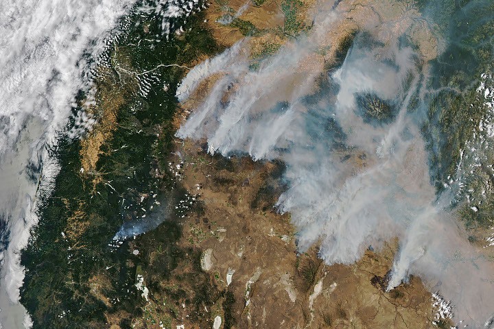
The subsequent days saw an alarming escalation. Fueled by persistent gusty winds and traversing landscapes severely desiccated by extreme drought conditions, these nascent blazes quickly expanded into formidable infernos. The region had been experiencing a prolonged period of abnormally high temperatures, transforming forests and grasslands into tinderboxes. By the afternoon of July 26, when NASA’s Aqua satellite captured a striking image of the region, the scale of the devastation was starkly evident. The satellite imagery revealed dozens of large, active fires, collectively charring hundreds of square miles and producing immense plumes of smoke that billowed northeastward, casting a thick blanket of haze over vast areas. This visible atmospheric impact prompted state officials to issue urgent air quality advisories for eastern Oregon, warning residents of hazardous smoke levels and recommending precautionary measures.
As of July 27, the situation remained critical, with more than 10,000 firefighters deployed across the state, battling fires that continued to challenge containment efforts.
The Perfect Storm: Drought, Heat, and Dry Lightning
The current wildfire emergency in Oregon is a confluence of specific meteorological and climatological factors that have created an exceptionally volatile environment. The primary ignition source, dry thunderstorms, is a well-understood but increasingly frequent threat in the Western U.S. Unlike typical thunderstorms that bring substantial rain, dry thunderstorms produce lightning without sufficient precipitation reaching the ground to extinguish potential fires. The moisture evaporates in the hot, dry air before it hits the forest floor, leaving behind only the incendiary electrical discharge.
This natural ignition mechanism found fertile ground in an Oregon already suffering from extreme drought. According to the U.S. Drought Monitor, large portions of central and eastern Oregon have been experiencing severe to extreme drought for months, a condition exacerbated by below-average snowpack in the preceding winter and early spring, followed by an unusually hot and dry summer. The cumulative effect has left vegetation—from underbrush to mature trees—critically dry and highly susceptible to ignition.
Record-breaking summer heatwaves have further compounded the problem. Elevated temperatures dehydrate vegetation, creating fuel that ignites more easily and burns more intensely. Coupled with gusty winds, these conditions create a scenario where small fires can rapidly spread, leading to explosive growth and making containment exceedingly difficult. The high temperatures also present significant challenges for firefighters, increasing the risk of heat-related illnesses and limiting optimal operational windows. The rugged topography of the Cascade Range and surrounding areas further complicates firefighting efforts, often requiring specialized aerial resources and arduous ground operations in remote, inaccessible terrain.
The Battle on the Ground: Firefighter Mobilization and State Response
The response to this multifaceted crisis has been immediate and extensive. Over 10,000 firefighters from local, state, federal, and even international agencies have converged on Oregon, representing a massive mobilization of resources. These dedicated men and women are confronting some of the most challenging conditions imaginable, working tirelessly to establish fire lines, protect communities, and suppress the advancing flames. Their efforts are supported by a vast array of equipment, including air tankers, helicopters, bulldozers, and specialized ground crews.
Several major complexes have emerged as the most critical threats. On the day the Aqua satellite image was captured, the National Interagency Fire Center identified the Hay Creek Complex, Brewer, Big Grass, Akawa Butte, and Powder River fires as the largest active blazes. Alarmingly, many of these fires were reported to be less than 5 percent contained, indicating the immense difficulty in gaining control over their spread. The sheer number of simultaneous large-scale fires has stretched resources thin, necessitating strategic prioritization and rapid deployment to areas of highest risk.
In response to the escalating danger to life and property, Oregon state officials invoked the Emergency Conflagration Act. This critical legislation allows the State Fire Marshal to mobilize additional firefighting resources from across the state and provide financial assistance to local jurisdictions battling fires that pose a significant threat to communities. This act was specifically engaged to protect communities threatened by particularly menacing fires, such as the Shingle, Bench, Beachcomb, and Second Flat fires, underscoring the immediate and severe danger these blazes presented to populated areas. Evacuation orders became a grim reality for many communities in the path of the fires, forcing thousands of residents to leave their homes with little notice. Emergency shelters have been established, and various support services are being coordinated to assist displaced families and individuals.
The Unseen Threat: Air Quality and Public Health
Beyond the immediate destruction of land and property, the extensive wildfires have unleashed a pervasive and insidious threat: hazardous air quality. The smoke plumes, visible from space, contain a complex mixture of particulate matter, gases, and aerosols that can travel hundreds, if not thousands, of miles. For residents in central and eastern Oregon, and potentially beyond, this has meant living under a persistent veil of smoke.
State environmental agencies and health departments swiftly issued air quality advisories, urging residents, particularly those with respiratory conditions, the elderly, and young children, to take precautions. These advisories typically recommend staying indoors, keeping windows and doors closed, and using air purifiers if available. Outdoor activities have been severely curtailed, impacting daily life, local economies, and public health infrastructure. Exposure to wildfire smoke can lead to a range of health problems, from immediate irritation of the eyes, nose, and throat to more serious respiratory and cardiovascular issues, especially with prolonged exposure. The long-term health implications of such widespread and intense smoke events are a growing concern for public health officials.
NASA’s Eye in the Sky: Monitoring and Data Analysis
In the face of these vast and dynamic fire events, satellite data provided by agencies like NASA has become an indispensable tool for fire managers, emergency responders, and scientists. Government satellite observations are a crucial component of a global system designed to track fire behavior, analyze emerging trends, and provide real-time intelligence to those on the ground.
NASA offers several real-time wildfire monitoring tools that are critical for understanding the scope and progression of these blazes. The Fire Information for Resource Management System (FIRMS) provides near real-time fire detection and mapping, allowing users to visualize active fire fronts and hot spots. The Worldview browser offers high-resolution satellite imagery, enabling a visual assessment of smoke plumes, burn scars, and overall fire extent. Additionally, the Fire Event Explorer provides a comprehensive dashboard for analyzing specific fire events, integrating various data layers to track perimeters, wind patterns, and fire intensity.
These tools leverage data from a constellation of satellites, including NASA’s Aqua and Terra satellites, which carry instruments like MODIS (Moderate Resolution Imaging Spectroradiometer), and the NOAA/NASA Suomi NPP and NOAA-20 satellites, equipped with VIIRS (Visible Infrared Imaging Radiometer Suite). These instruments detect thermal anomalies associated with fires, map their extent, and monitor smoke plumes, offering an unparalleled perspective on the unfolding crisis from above. This data aids firefighters in strategic planning, helps determine resource allocation, and provides crucial information for public safety warnings and air quality forecasts. Scientists also use this data to study the long-term ecological impacts of fires and to better understand the role of climate change in exacerbating fire seasons.
Broader Context: A Worsening Trend Across the United States
The severe fire season gripping Oregon is not an isolated incident but rather a stark illustration of a broader and worsening trend across the United States. As of July 27, 2026, the National Interagency Fire Center (NIFC) reported that fires had burned more than 4 million acres across the nation. This figure significantly surpasses the 10-year average (2016-2025) of 3.4 million acres for the same period, highlighting the exceptional severity of the current fire year.

The increase in wildfire frequency, intensity, and acreage burned is a complex issue, but scientific consensus increasingly points to climate change as a major contributing factor. Rising global temperatures lead to hotter, drier conditions, extending fire seasons and increasing the flammability of vegetation. Changes in precipitation patterns, with more frequent and intense droughts, further exacerbate these conditions. Forest management practices, historical fire suppression policies, and the expansion of the wildland-urban interface also play roles in the current crisis, creating a challenging environment for both prevention and response.
The interconnectedness of these factors suggests that severe wildfire seasons like the one currently unfolding in Oregon may become the new norm, necessitating a re-evaluation of land management strategies, emergency preparedness, and public education across fire-prone regions.
Looking Ahead: Recovery, Resilience, and Prevention
As firefighters continue their arduous work to contain the blazes, the focus will inevitably shift towards recovery and long-term prevention. The immediate aftermath will involve assessing the full extent of the damage, supporting affected communities, and beginning the process of rehabilitation for burned landscapes. This includes mitigating risks of post-fire flooding and erosion, which can follow severe wildfires, especially in mountainous terrain.
Longer-term strategies will need to address the underlying vulnerabilities that have contributed to this catastrophic season. These may include enhanced forest thinning and prescribed burning programs to reduce fuel loads, particularly in areas prone to high-intensity fires. Investment in fire-resistant infrastructure and updated building codes in the wildland-urban interface will be crucial for protecting homes and communities. Furthermore, public education campaigns on fire safety, defensible space around homes, and the responsible use of outdoor spaces will remain vital.
The current crisis in Oregon serves as a powerful reminder of the increasing challenges posed by a changing climate and the critical need for comprehensive, proactive approaches to wildfire management. The dedication of the thousands of firefighters and emergency personnel on the front lines, combined with the insights from advanced satellite monitoring, provides hope for containment, but the road to recovery and a more resilient future will be long and demanding.